Table of Contents
LOCATION, DIMENSIONS AND FRONTIERS
Location
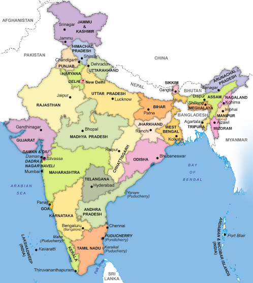
India is the seventh largest country in the world in terms of area—accounting for about 2.4% of total world area and also ranks second in terms of population. It lies in the northern hemisphere between 8°4′ N and 37°6′ N parallels of latitude and between 68°7′ E and 97°25′ E meridians of longitude and is part of the Asian continent. The
country can be divided into 6 zones—north, south, east, west, central and north-east zone. It has 28 states and 7 union territories.
India stands apart from the rest of Asia, marked off by mountains and the sea which give her distinct geographical entity. Bounded by the great Himalayas in the north, it stretches southwards and at the Tropic of Cancer (23° 30′ N) tapers off into the Indian Ocean between Bay of Bengal on the east and the Arabian Sea on the west. It is a country in South Asia that lies entirely on the Indian Plate in the northern portion of the Indo-Australian Plate.
Important Facts:
| Distance from north to south | 3214 km |
| Distance from east to west | 2933 km |
| Length of coastline | 7516.6 km |
| Length of land frontier | 15,200 km |
| Total geographic land area | 32,87,263 km2 |
| Percentage of earth’s surface covered by India | 2.40% |
| Percentage of world’s population living in India | 17.50% |
| Territorial Sea | 12 nm (nautical miles) |
| Contiguous Zone | 24 nm (nautical miles) |
| Exclusive Economic Zone | 200 nm (nautical miles) |
| Longest River | Ganga |
| Largest Lake | Lake Chilka |
| Highest Point | Mt. K2 (8611 m) |
| Highest Point of Himalayas | Kanchan Junga (8598 m) |
| Lowest Point | Kuttanad (-2 .2 m) |
| Northernmost Point | Siachin Glacier near Karakoram |
| Southernmost Point | Indira Point, Great Nicobar Andaman and Nicobar Islands |
| Westernmost Point | West of Ghur Mota, Gujarat |
| Easternmost Point | Kibithu, Arunachal Pradesh |
| Highest Altitude | Kanchanjunga, Sikkim |
| Lowest Altitude | Kuttanad, Kerala |
International Boundaries Touching Indian States
| Afghanistan 106 km | 1 state [Jammu and Kashmir (Pakistan occupied area)] |
| Bangladesh 4096 km | 5 states [West Bengal, Mizoram, Meghalaya, Tripura, Assam] |
| Bhutan 699 km | 4 states [West Bengal, Sikkim, Arunachal Pradesh, Assam] |
| China 4057 km | 5 states [Jammu and Kashmir, Himachal Pradesh, Uttarakhand, Sikkim, Arunachal Pradesh] |
| Nepal 1751 km | 5 states [Bihar, Uttarakhand, Uttar Pradesh, Sikkim, West Bengal] |
| Myanmar | 4 states [Arunachal Pradesh, Nagaland, Manipur, Mizoram] |
| Pakistan 3323 km | 4 states [Jammu and Kashmir, Punjab, Rajasthan, Gujarat] |