MOUNTAINS
• Nearly 27% of the world’s land surface is covered by mountains.
• It is from the mountains that up to 80% of the planet’s fresh surface water come from.
• According to the UN’s Food and Agriculture Organization (FAO), about 12% of the world’s population lives in the mountains, but over 50% are directly or indirectly dependent on mountain resources.
CLASSIFICATION OF MOUNTAINS
• The mountains, on the basis of their mode of formation, can be classified as:
- Fold Mountains
- Block Mountains
- Volcanic Mountains/ Accumulated Mountains
- Residual Mountains/ Relict Mountains
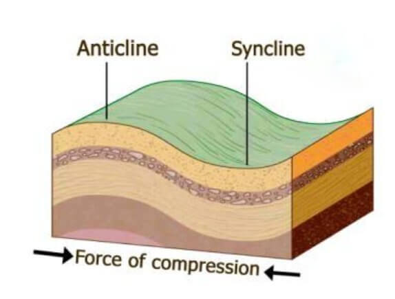
Fold Mountains
• Mountain ranges mainly consisting of uplifted folded sedimentary rocks are called Fold Mountains.
• They are formed due to the force of compression arising from the endogenic or internal forces.
• Synclines (trough) and anticlines (crest) are part of Fold Mountains.
• The Himalayas in Asia, the Alps in Europe, the Rockies in North America, and the Andes in South America are the most prominent fold mountains of the world.
• Since these mountain ranges were formed during the most recent mountain building period, they are also known as Young Fold Mountains.
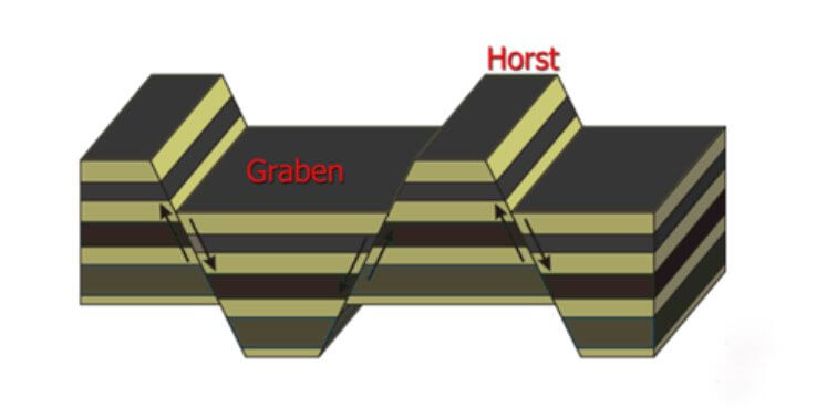
Block Mountains
• Block Mountains are also formed by the internal or endogenic earth movements which cause the force of tension and faulting.
• The down-lifting or uplifting of land in between two parallel faults results in the formation of Block Mountains.
• A block mountain is also called as Horst and the rift valley formed as a result of faulting is called Graben.
• Examples: The Sierra Nevada in North America, Black Forest Mountains in Germany etc are typical examples of Block Mountains.
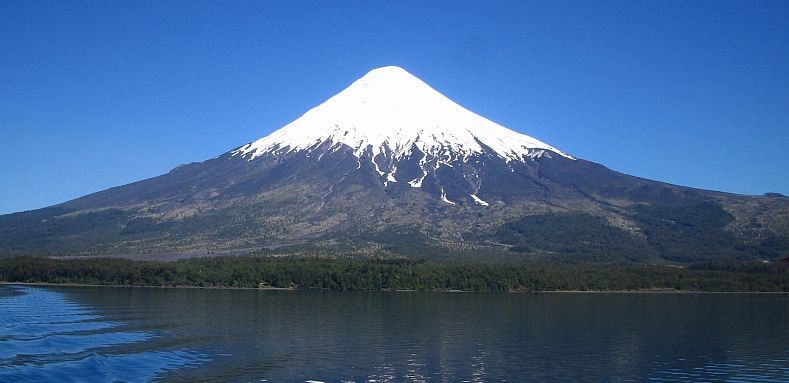
Volcanic Mountains or Accumulated Mountains
• The mountains formed by the accumulation of volcanic materials are called as Volcanic Mountains or Mountains of accumulation.
• Examples: Mount Mauna Loa in Hawaii Island, Mount Popa in Myanmar, Fuji Yama in Japan etc. are some examples.
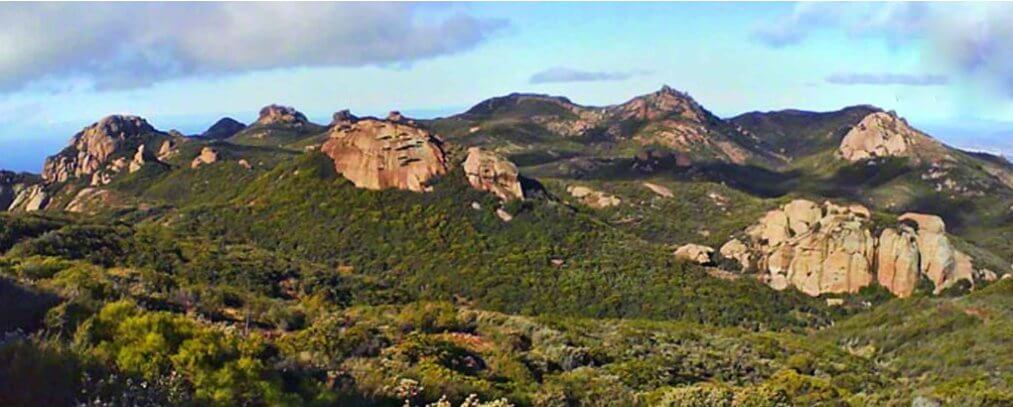
Residual Mountains or Relict Mountains
• Weathering (as part of exogenic processes) acts upon the earth’s crust constantly.
• To a large extent, the process of wearing down depends on the shape and structure of the rocks upon which it acts.
• So, in some cases, some portions of an elevated area escape from the process of weathering due to the hardness of the materials it is made of.
• These portions remain unweathered while its surrounding area gets eroded constantly. This results in the formation of Residual or Relict Mountains.
• Examples: Hills like Nilgiri, Palkonda, Parasnath and Rajmahal and Mountains like the Aravalli, the Vindhya, and the Satpura are some of the examples of Relict Mountains in India.
Economic Significance of Mountains
• A storehouse of resources: Mountains are the storehouse of natural resources. Large resources of minerals like petroleum, coal, limestone are found in mountains. The mountains are the main source of timber, lac, medical herbs, etc.
• Generation of hydro-electricity: Hydro-electricity is mainly generated from the waters of perennial rivers in the mountains.
• An abundant source of water: Perennial rivers arising in the snow-fed or heavily rain-fed mountains are one of the important sources of water. They help in promoting the irrigation and provide water for many other purposes.
• Formation of fertile plains: The rivers that originate from the high mountain ranges bring silt along with water to the lower valleys. This helps in the formation of fertile plains and further the expansion of agriculture and related activities.
• Natural political frontiers: The mountains can also act as natural boundaries between the two countries. They have a prominent role in protecting the country from external threats.
• Effects on climate: They serve as a climatic divide between two adjoining regions. The mountains cause orogenic rainfalls, diversion, and blocking of cold winds, etc.
• Tourist centres: The pleasant climate and beautiful sceneries of the mountains have led to their development as centres of tourist attraction.
PLATEAUS
• A plateau is an elevated area with a more or less levelled land on its top. It has a large area on its top and a steep slope on its sides.
• They are also called as high plains or tablelands.
• The plateaus cover about 18% of the earth’s land surface.
CLASSIFICATION OF PLATEAUS
• On the basis of their geographical location and structure of rocks, the plateaus can be classified as:
- Intermontane Plateaus
- Piedmont plateaus
- Continental plateaus
- Volcanic plateaus
- Dissected plateaus
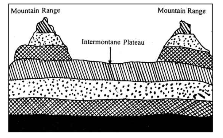
Intermontane Plateaus
• The plateaus which are bordering the mountain ranges (generally fold mountains) or are partly or fully enclosed within them are the intermontane plateaus.
• The word ‘intermontane’ means ‘between mountains’.
• Intermontane plateaus are the highest in the world.
• They have nearly horizontal rock layers which are raised to very heights by vertical movements of the earth.
• Examples: The Plateau of Tibet is an example of the intermontane plateau which is surrounded by the fold mountains like the Himalayas, the Karakoram, the Kunlun and the Tien Shah.
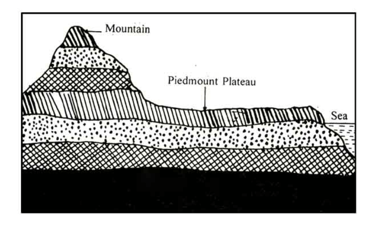
Piedmont Plateaus
• Plateaus which is situated at the foot of a mountain and is locked on the other side by a plain or a sea/ ocean is called as a piedmont plateau.
• The word ‘piedmont’ means ‘foot of a mountain’.
• They are also called as Plateaus of denudation as the areas once were high to the level of mountains, have now been reduced to the foot level of the mountain by various agents of erosion.
• Examples: The Malwa Plateau is an example of piedmont plateau.
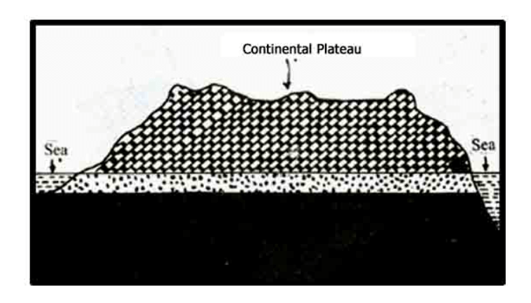
Continental Plateaus
• They are formed either by an extensive continental upliftment or by the spread of horizontal basic lava (less viscous) sheets completely covering the original topography.
• This kind of plateaus shows an abrupt elevation in contrast to the nearby lowland or sea (i.e. more steepness on sides).
• The Continental Plateaus are also known as Plateaus of Accumulation.
• Examples: Plateau of Maharashtra is an example of the continental plateau.
Volcanic Plateaus
• A volcanic plateau is a plateau produced by volcanic activity. There are two main types: lava plateaus and pyroclastic plateaus.
• Lava plateaus are formed by highly fluid basaltic lava during numerous successive eruptions through numerous vents without violent explosions.
• Pyroclastic volcanic plateaus are produced by massive pyroclastic flows and they are underlain by pyroclastic rocks.
• For ex. Antrim Plateau of Northern Ireland, NW part of Deccan Plateau & Columbia Snake Plateau (Biggest one).
Dissected Plateaus
• A dissected plateau is a plateau area that has been severely eroded so that the relief is sharp. Such an area may appear as mountainous.
• Dissected plateaus are distinguishable from orogenic mountain belts by the lack of folding, metamorphism, extensive faulting, or magmatic activity that accompanies orogeny (mountain building).
• For Ex. Scottish Highlands
The economic significance of Plateaus
• A storehouse of minerals: Most of the minerals in the world are found in plateaus. The extraction of minerals in plateaus is relatively easier on plateaus than mountains. The major portions of industrial raw materials are obtained from plateaus. We get gold from the plateau of Western Australia; copper, diamond and gold from the plateaus of Africa; and coal, iron, manganese and mica from the Chottanagpur Plateau in India.
• Generation of hydel-power: The edges of plateaus form waterfalls which provide ideal sites for generating hydel power.
• Cool climate: The higher parts of the plateaus even in tropical and sub-tropical regions have a cool climate.
• Animal rearing and agriculture: plateaus have large grassland areas suitable for animal rearing especially sheep, goat, and cattle. The lava plateaus when compared to other plateaus are richer in minerals and hence used for agriculture as the soil is very fertile.
PLAINS
• Plains are the most important landforms found on the earth surface.
• A plain is nothing but a low-lying relatively flat land surface with very gentle slope and minimum local relief.
• About 55% of the earth’s land surface is occupied by plains.
• Most of the plain have been formed by deposition of sediments brought down by rivers.
• Besides rivers, some plains have also been formed by the action of the wind, moving ice and tectonic activities (Refer exogenic processes).
CLASSIFICATION OF PLAINS
On the basis of their mode of formation, plains can be classified as:
- Structural plain
- Erosional plains
- Depositional plains
Structural Plains
• These plains are mainly formed by the upliftment of a part of the sea floor or continental shelf.
• They are located on the borders of almost all the major continents.
• The structural plains may also be formed by the subsidence of areas.
• Examples include Russian Platforms, Great plains of USA & Central lowlands of Australia
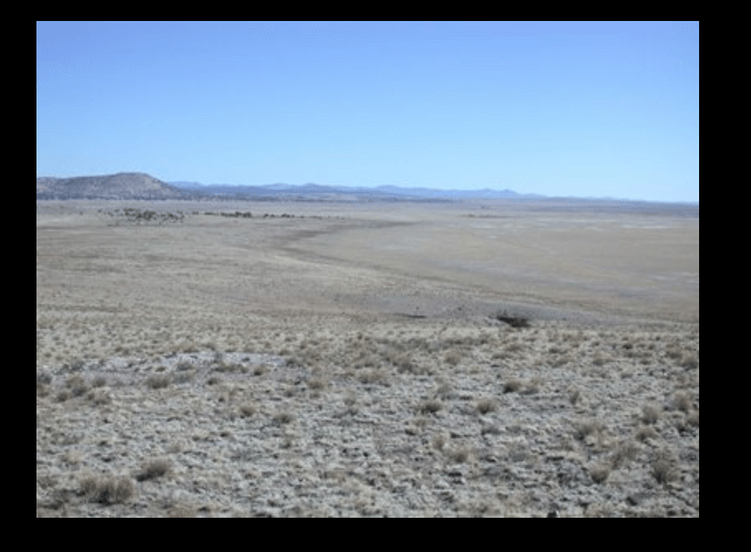
Erosional Plains (Peneplains)
• Erosional plains are formed by the continuous and longtime erosion of uplands.
• The surface of such plains is hardly smooth and hence, they are also called as Peneplains, which means almost plain.
• These plains are carved by the agents of erosion (Rain, river, ice, and wind)
• Such plains of denudation are described as Peneplains, which means almost plains.
• In glaciated regions, glaciers & ice sheets scours & levels the land forming ice scoured plains
• However scooped out by the ice are now filled by the lakes for ex. in Northern Europe & Northern Canada.
• In arid & semi-arid regions, wind erosion lowers the level of the land which are called Reg in Africa
• Mechanical weathering in arid & semi-arid areas worns mountain slopes leaving a gentle slope, known as Pediplains or Pediments; with remaining steep hills known as Inselbergs
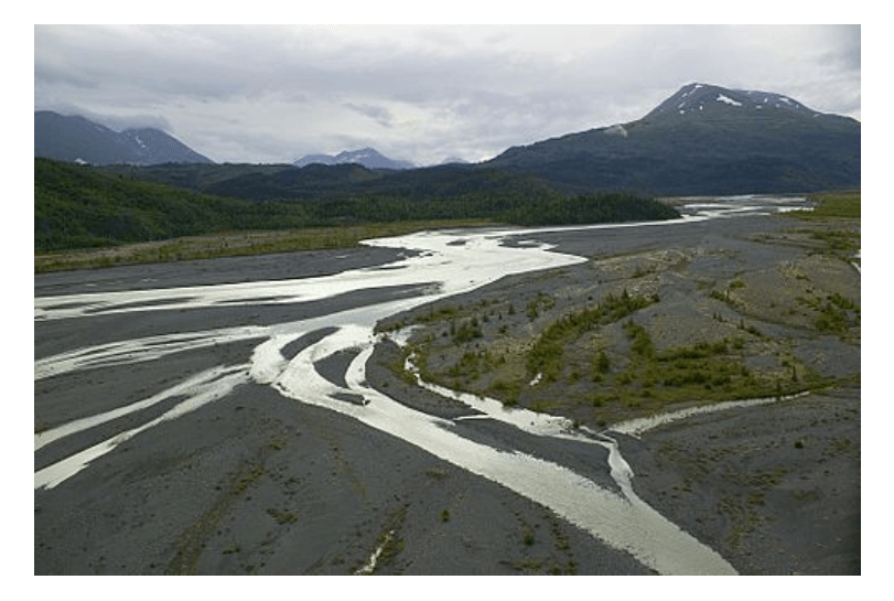
Depositional Plains
• These plains are formed by the depositional activity of various geomorphic agents.
• When plains are formed by the river deposits, they are called as riverine or alluvial plains.
• The depositions of sediments in a lake give rise to a Lacustrine Plain or Lake Plains. The Valley of Kashmir is an example of lacustrine plain.
• When plains are formed by glacial deposits, they are called as Glacial or Drift Plains.
• When the wind is the major agent of deposition, those plains are called as Loess Plains.
• For ex. Gangetic plain (for rice & jute), Nile delta of Egypt (for rice & cotton) & Hwang Ho plain in China
The economic significance of Plains
• Fertile soil: The plains generally have deep and fertile soil. As they have a flat surface, the means of irrigation can be easily developed. That is why plains are called as the ‘Food baskets of the world’.
• The growth of industries: The rich agricultural resources, especially of alluvial plains, have helped in the growth of agro-based industries. Since the plains are thickly populated, plenty of labour is available for the intense cultivation and for supplying the workforce for the industries.
• Expansion of means of transportation: The flat surface of plains favours the building of roads, airports and laying down railway lines.
• Centres of civilizations: Plains are centres of many civilizations.
• Setting up of cities and towns: Easy means of transportation on land and the growth of agriculture and industries in plains have resulted in the setting up and expansion of cities and towns. The most developed trade centres and ports of the world are found in the plains only and as much as 80% of the world’s population lives here.
LAKES
• Lakes occupy the hollows of the land surface in which water accumulates & vary tremendously in size, shape, depth & mode of formation.
• The tiny ones are no bigger than ponds or pools, but the large ones are so extensive that they merit the name of the seas e.g. Caspian Sea.
• It must be noted that the lakes are only temporary feature of the earth crust & eventually be eliminated by draining & silting up.
• Most of the lakes in the world are fresh water lakes fed by the rivers
• But in regions where evaporation is greater than precipitation & only few streams filling up the lake, form saline water lakes such as Dead sea & Great Salt Lake of Utah.
- Lakes formed by Earth movement
Tectonic lakes
• Due to warping, bending & fracturing of earth crust, tectonic depressions occur which give rise to lakes of immense sizes & depths
• Examples : Lake Titicaca (Andes) – Highest lake of the world, Caspian Sea (Largest lake of the world & 5 times larger than its nearest rival i.e. Lake Superior)
Rift Valley Lakes
• Due to faulting, a rift valley is formed by sinking of land between two parallel faults which is deep, narrow & elongated in character.
• Water collect in these troughs & their floors are often below sea level
• Eg. Lake Tanganyika (World’s deepest lake) & Dead Sea (World’s lowest lake)
- Lakes formed by Glaciation
Cirque lakes / Tarns
• A glacier on its way down the valley leaves behind circular hollows in the heads of the valleys up in the mountains known as corries or cirque
• Their over deepened floors may be filled with water to form cirque lakes
• Those that occupy long & deep glacial troughs down the valley are termed as Ribbon lakes
Kettle Lakes
• They are basically depressions in the outwash plain left by the melting of masses of stagnant ice.
• They are irregular because of the uneven moraine surface & are never of any great size or depth.
Rock Hollow Lakes
• Formed by ice scouring when valley glaciers or ice sheets scoop out hollows on the rock surface (lakes enclosed within a rock hollow)
• Such lakes are abundant in Finland (Land of lakes)
Lakes formed due to Moraine damming of Valleys
• Valley glaciers often deposit moraine debris across a valley so that lakes are formed when water accumulates behind the barrier.
• Both lateral & terminal moraines are capable of damming valleys.
Lakes formed due to deposition of glacial drifts
• In glaciated lowlands with a predominant drumlin landscape, where drainage is poor
• There are intervening depressions which are often waterlogged, forming small lakes
- Lakes formed by volcanic activity
Crater & Caldera Lakes
• During a volcanic explosion, top of the cone may be blown off, leaving behind a natural hollow called a crater, which may be enlarged by subsidence into a caldera
• In dormant & extinct volcanoes, rain falls straight into the crater or caldera which has no superficial outlet & forms a crater or caldera lake
Lava Blocked Lakes
• In volcanic regions a stream of lava may flow across a valley which may solidify
• Solidifying of lava may dam the river, leading to the formation of lava blocked lakes.
Lakes formed due to subsidence of volcanic land surface
• The crust of hollow lava flow may collapse
• Subsidence leaves behind a wide & hollow depression in which a lake may form.
- Lakes formed by Erosion
Karst lakes
• The solvent action of rain water on limestone carves out solution hollow.
• When these become clogged with debris, lakes may form in them.
• The collapse of limestone roofs of underground caverns may result in the exposure of long, narrow lakes that were once underground.
• The large depressions called Polje, which normally do not have any outlet, may contain lakes.
Wind deflated lakes
• The deflating action of winds in deserts creates deep hollows which may reach water table via which water seeps out forming small shallow lakes.
• Excessive evaporation causes these to become salt lakes or Playas.
- Lakes formed by Deposition
Lakes formed due to river deposits
• A river may shorten its course during a flood by cutting its meandering loops leaving behind a horseshoe shaped channel called ox – bow lake.
Lakes formed due to marine deposits
• The action of wind & waves may isolate lagoons along the coasts, enclosed by narrow spit of land known as lagoon lakes.
• Lagoon is a shallow body of water separated from a larger body of water by barrier islands or reefs.
• In East Germany & Poland lagoons are called Haffs.
Lakes formed due to landslides, screes & avalanches
• Landslides or screes may block valleys so that rivers are dammed, leading to formation of temporary lakes.
• Lakes formed by these processes are also known as barrier lakes.
• Such lakes are short lived because the loose fragments that pile up across the valleys will soon rupture under pressure & will give way to water.
• When they suddenly give way, the dammed water rushes down causing floods
- Lakes formed by Human & Biological activities
Man-made lakes
• Besides the natural lakes, man has created artificial lakes by erecting a concrete dam across a river valley
• This is done so that the river water can be kept in check to form reservoirs.
Lakes made by animals
• Animals like Beavers are particularly interesting.
• They live in communities & construct dams across the rivers with timber, mud & soil.
• Such Beaver dams are quite permanent & modify the natural environment in such a way that the overall ecosystem builds upon the change, making beavers a keystone species.
Other type of man-made lakes
• Ornamental lakes, especially made to attract tourists
• Lakes made by men through mining activities
• Inland fishing lakes to develop inland fish culture
IMPORTANT LAKES OF THE WORLD


Lake Baikal – Deepest Lake
• Located in Siberia, Russia
• The deepest lake in the world [1,637 metres deep]
• It is the world’s largest lake by volume.
• It is the second longest.
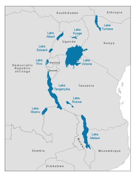
Lake Tanganyika – Longest Lake
• The longest lake in the world [660 kilometres long]
• It is also the second largest by volume.
• It is the second deepest lake in the world, after Lake Baikal.
World’s Highest and Lowest Lakes
• The world’s highest lake, if size is not a criterion, may be the crater lake of Ojos del Salado, at 6,390 metres. It is in Andes.
• The highest large lake in the world is the Pumoyong Tso (Pumuoyong Tso), in the Tibet Autonomous Region of China. [5,018 metres above sea level]
• The world’s highest commercially navigable lake is Lake Titicaca in Peru and Bolivia border at 3,812 m. It is also the largest lake in South America.
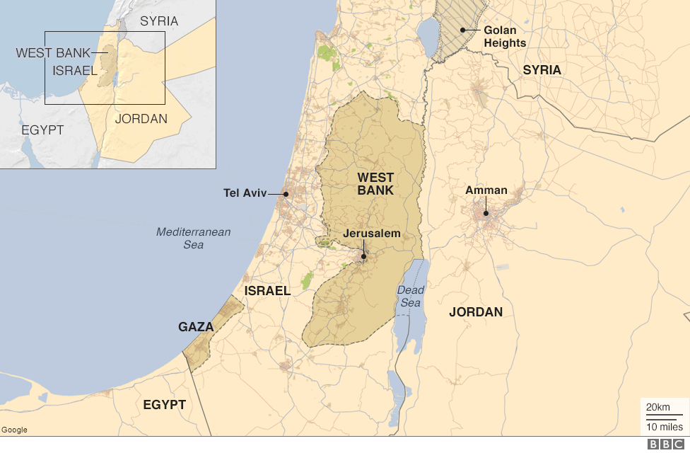
• The world’s lowest lake is the Dead Sea, bordering Israel and Jordan at 418 metres below sea level. It is also one of the lakes with highest salt concentration.
The Largest Lakes (surface area) by Continent
Australia – Lake Eyre (salt lake)
Africa – Lake Victoria, also the third-largest freshwater lake on Earth. It is one of the Great Lakes of Africa.
Antarctica – Lake Vostok (subglacial)
Asia – Lake Baikal (if the Caspian Sea is considered a lake, it is the largest in Eurasia, but is divided between the two geographic continents)
Europe – Lake Ladoga, followed by Lake Onega, both located in northwestern Russia.
North America – Lake Superior.
South America – Lake Titicaca, which is also the highest navigable body of water on Earth at 3,812 metres above sea level. The much larger Lake Maracaibo is a contiguous body of water with the sea, so it is ignored.
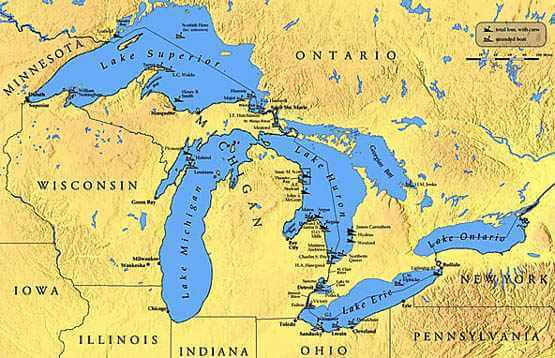
Great Lakes
• Great Lakes of North America are a series of interconnected freshwater lakes which connect to the Atlantic Ocean through the Saint Lawrence Seaway.
• Consisting of Lakes Superior, Michigan, Huron, Erie, and Ontario [in the order of west to east], Superior, Huron, Michigan, Erie, and Ontario [In the order of largest to smallest]
• Lake Superior is the largest continental lake in the world by area, and Lake Michigan is the largest lake that is entirely within one country.
• The Great Lakes are today used as a major water transport corridor for bulk goods.
• The Great Lakes Waterway connects all the lakes; the smaller Saint Lawrence Seaway connects the lakes to the Atlantic oceans.
Dead Sea
• Also called the Salt Sea due to very high salinity
• Lake bordering Jordan to the east, and Palestine and Israel to the west
• It is Earth’s lowest elevation on land
Aral Sea
• It was a lake lying between Kazakhstan in the north and Uzbekistan, in the south.
• Aral Sea has been steadily shrinking since the 1960s after the rivers that fed it were diverted by Soviet irrigation projects.

African Great Lakes
• Series of lakes constituting the part of the Rift Valley lakes in and around the East African Rift
• They include Lake Victoria, the second largest fresh water lake in the world, and Lake Tanganyika, the world’s second largest in volume as well as the second deepest.
• African Great Lakes – lakes in African rift
Largest Lakes by Surface Area
[Caspian Sea Excluded in all facts]Lake Superior – North America
Lake Victoria – Africa
Lake Huron – North America
Lake Michigan – North America
Largest Lakes by Volume
Baikal – Asia
Tanganyika – Africa
Superior – North America
Deepest Lakes in the World
Lake Baikal – Asia
Lake Tanganyika
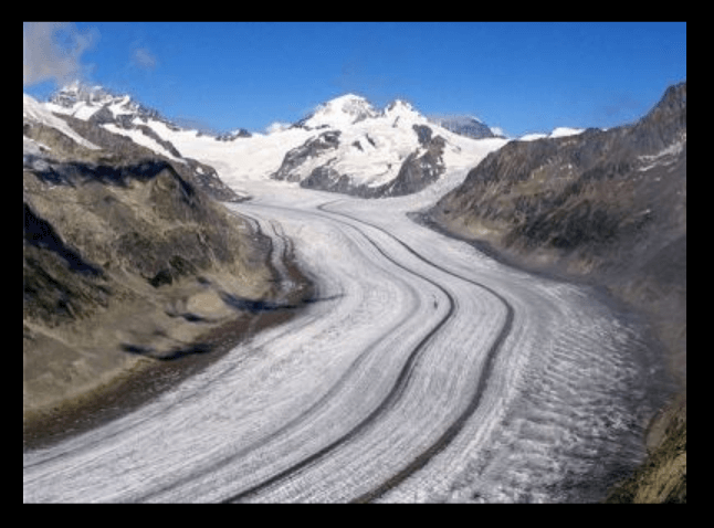
GLACIERS
• Glaciers are a bulk of ice moving under its own weight. It forms in areas where the amassing of snow goes beyond its ablation over many years.
• They are generally seen in the snow-fields.
• This largest freshwater basin covers around 10 percent of the land surface of the Earth.
• According to the topography and the location of the glacier, it can be categorized as Mountain Glacier (Alpine Glaciers) or Continental Glacier (Ice Sheets).
• The Continental Glacier moves outward in all directions whereas the Mountain Glacier moves from a higher to a lower altitude.
Types of Glaciers
• Glaciers can be distinguished in two major categories based on its type:

Glacial Landforms
• Glaciers have played a prominent role in the shaping of landscapes in the mid and high latitudes of alpine environments. The major landforms made by glaciers are:
- Glacial Erosional Landforms
- Glacial Depositional Landforms

Glaciers in India

Gangotri Glacier
• Largest Glacier in Uttarakhand
• Source of the Ganges (River Bhagirathi)
• The Gangotri glacier originates at the northern slope of Chaukhamba range of peaks in Garhwal Himalayas.
• Gangotri is not a single valley glacier, but a combination of several other glaciers.
Carbon Deposits on Gangotri
• The Wadia Institute of Himalayan Geology is an Autonomous Institute administered by the Department of Science and Technology.
• They have the Chirbasa station at a height of 3,600 m and Bhojbasa station at a height of 3,800 m.
• They conduct research on the amount of carbon deposits on the important glaciers of the Himalayas. Gangotri being the source of the Ganges, is one of the most important Glaciers in the country.
• According to recent data from the research, the concentration of black carbon present on the Gangotri Glacier has doubled when compared to the results of the past few years.
• Primary reason for this is the agricultural burning and the forest fires in the nearby regions.