EARTHQUAKES
• An Earthquake is a tectonic movement caused by endogenetic (originating within the earth) thermal conditions inside earth’s interior which is transmitted through the surface layer of the earth.
What is an Earthquake?
• It is shaking or trembling of the earth surface causing energy to release suddenly. An earthquake can range from a faint tremor to a wild motion capable of shaking building apart. Minor tremors caused by gentle waves of vibration within the earth s crust occur every few minutes. Major earthquakes, usually caused by movement along faults, can be very disastrous particularly in a densely populated area.
• Earthquakes themselves may cause only restricted damage in the regions of occurrence, but their aftershocks can be very catastrophic. An aftershock is an earthquake of the smaller magnitude that occurs after the main shock. They are also known to cause Tsunami waves.
• Nearly 54% of land area in India is prone to earthquakes. Earthquakes are by far the most unpredictable and highly destructive of all the natural disasters. It not only damages and destroys the settlements, infrastructure etc. but also result in loss of lives of men and animals.
Focus and epicentre of an earthquake
• Focus – The point within the earth s crust where an earthquake originates is called the focus. It is also referred as seismic focus or hypocenter. It generally lies within the depth of 60 kilometres in the earth crust.
• Epicentre – The point vertically above the focus on the earth s surface is known as epicenter. Earthquake travel in the form of the longitudinal wave from the focus to epicentre. The intensity is the highest at the epicentre. That is why the maximum destruction occurs at and around the epicentre. The intensity of vibrations decreases as one moves away from the epicentre.
Causes of earthquakes
Plate Movements
• Folding, faulting and displacement of rock strata, upwarping and downwarping of crust are some of the main causes of earthquakes. Some examples of this type of earthquakes are the San Francisco earthquakes of California in 1906, the Assam earthquakes of 1951, the Bihar earthquakes of 1935.
Volcanic eruptions
• The violent volcanic eruptions put even the solid rocks under great stress. It causes vibrations in the earth s crust. But, these earthquakes are limited to the areas of volcanic activity such as the circum-pacific ring of fire and the Mid-Atlantic Ridge.
• An important example of this type of earthquake includes the earthquake preceding the eruption of Mauna Loa volcano of Hawaii Island in 1868.
Forces within the earth
• Gaseous expansion and contraction within the earth can cause stress in strata which build up over time and is released suddenly in the form of earthquakes.
Exogenic forces
• An earthquake may also be caused due to landslide and collapse of cave or mines etc. which can cause a sudden release in energy.
Man-made causes
• These may range from dam building, mining, dredging, road building, drilling etc.
Types of earthquakes
• Tectonic earthquakes – The most common ones are the tectonic earthquakes. These are generated due to sliding of rocks along a fault plane.
• Volcanic Earthquakes – A special class of tectonic earthquake is sometimes recognised as a volcanic earthquake. They are generated due to violent volcanic eruptions. However, these are confined to areas of active volcanoes.
• Collapse Earthquakes – In the areas of intense mining activity, sometimes the roofs of underground mines collapse causing minor tremors. These are called collapse earthquakes.
• Explosion Earthquakes – Ground shaking may also occur due to the explosion of chemical or nuclear devices. Such tremors are called explosion earthquakes.
• Reservoir-induced Earthquakes – The earthquakes that occur in the areas of large reservoirs are referred to as reservoir-induced earthquakes.
- On the basis of focus, earthquakes can be classified as a shallow focus ( focus located at depth of up to 50 km), intermediate focus ( 50 – 250 km depth) and deep focus earthquakes (foci depth of up to 700 km).
Earthquake-prone zones in India
• Over 55% of the land area in India is vulnerable to earthquakes. Some of the most vulnerable states are Jammu and Kashmir, Himachal Pradesh, Uttarakhand, Sikkim, and the Darjeeling and subdivision of West Bengal and all the seven states of the northeast.
• Apart from these regions, the central-western parts of India, particularly Gujarat and Maharashtra have also experienced some severe earthquakes.
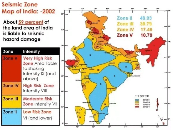
• Bureau of Indian Standards, based on the past seismic history, grouped the country into four seismic zones, viz. Zone II, III, IV and V. Of these, Zone V is the most seismically active region, while zone II is the least. The current division of India into earthquake-prone zones does not use Zone I.
• The Modified Mercalli (MM) intensity, which measures the impact of the earthquakes on the surface of the earth, broadly associated with various zones, is as follows:
Seismic Zone Description Intensity on MM scale
Zone II Low intensity zone VI (or less)
Zone III Moderate intensity zone VII
Zone IV Severe intensity zone VIII
Zone V Very severe intensity zone IX (and above)
Areas covered under different Seismic Zones
Zone – V covers 10.79% area of the country. It comprises entire northeastern India, parts of Jammu and Kashmir, Himachal Pradesh, Uttaranchal, Rann of Kutch in Gujarat, part of North Bihar and Andaman & Nicobar Islands.
Zone – IV covers 17.49% area of the country. It comprises remaining parts of Jammu and Kashmir and Himachal Pradesh, National Capital Territory (NCT) of Delhi, Sikkim, Northern Parts of Uttar Pradesh, Bihar and West Bengal, parts of Gujarat and small portions of Maharashtra near the west coast and Rajasthan.
Zone III covers 30.79% area of the country. It comprises Kerala, Goa, Lakshadweep islands, remaining parts of Uttar Pradesh, Gujarat and West Bengal, Parts of Punjab, Rajasthan, Madhya Pradesh, Bihar, Jharkhand, Chhattisgarh, Maharashtra, Orissa, Andhra Pradesh, Tamil Nadu and Karnataka.
Zone – II covers 40.93% area of the country. It comprises major parts of peninsular region. Karnataka Plateau falls in this zone.
Distribution of earthquakes in the world
• The occurrence of an earthquake is a phenomenon of almost every part of the world. But, there are two well-defined belts where they occur more frequently. These belts are the Circum-Pacific belt and the Mid-world mountain belt.
• The Circum Pacific Belt comprises the western coast of North and South America; the Aleutian Islands and island groups along the eastern coasts of Asia such as Japan and Philippines. As it encircles the Pacific Ocean from end to end, it is named as such. The earthquakes in this belt are associated with the ring of mountains and volcanoes. It is estimated that about 68 % of earthquakes of the world occur in this belt alone.
• The Mid-world Mountain Belt extends from the Alps with their extension into the Mediterranean the Caucasus and the Himalayan region and continues into Indonesia. About 21 % of total earthquakes of the world originate in this belt. Remaining 11 % occur in the other parts of the world.
EARTHQUAKE WAVES
• Earthquake waves are energy waves, generated by the sudden release of energy from within the earth surface during an earthquake.
• The velocity of waves changes as they travel through materials with different densities. The denser the material, the higher is the velocity.
• Their direction also changes as they reflect or refract when coming across materials with different densities.
• Earthquake waves are basically of two types: body waves and surface waves.
Body Waves
• Body waves are generated due to the release of energy at the focus and move in all directions travelling through the body of the earth. Hence, the name body waves.
• Travelling through the interior of the earth, body waves arrive before the surface waves emitted by an earthquake.
• These waves are of a higher frequency than surface waves.
Surface Waves
• The body waves interact with the surface rocks and generate a new set of waves called surface waves.
• These waves move along the surface.
• The surface waves are the last to report on a seismograph.
• Surface waves are considered to be the most destructive waves.
• They cause displacement of rocks, and hence, the collapse of structures occurs.
Types of Body waves
• There are two types of body waves. They are called P and S-waves.
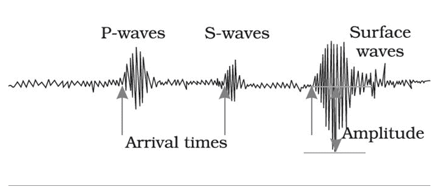
P waves
• These are also called primary waves .
• P-waves move faster and are the first to arrive at the surface.
• The P-waves are similar to sound waves.
• They travel through gaseous, liquid and solid materials.
• P-waves vibrate parallel to the direction of the wave.
• This exerts pressure on the material in the direction of the propagation.
• Hence, it creates density differences in the material leading to stretching and squeezing of the material.
S waves
• These are called secondary waves.
• S-waves arrive at the surface with some time lag.
• They can travel only through a solid medium.
• S-waves vibrate perpendicular to the direction of the wave in the vertical plane.
• Hence, they create troughs and crests in the material through which they pass.
Measurement of earthquakes
The earthquake events are scaled either according to the magnitude or intensity of the shock.
• Richter scale – The magnitude scale is known as the Richter scale. The magnitude relates to the energy released during the quake. The magnitude is expressed in absolute numbers, 0-10.
• Mercalli scale – The intensity scale is named after Mercalli, an Italian seismologist. The intensity scale takes into account the visible damage caused by the event. The range of intensity scale is from 1-12.
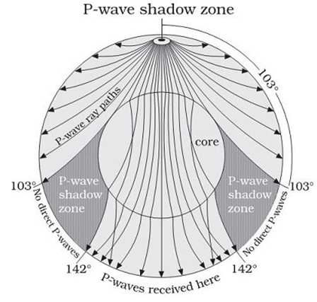
Shadow Zone of earthquakes
• When an earthquake occurs, earthquake waves radiate out spherically from the earthquake’s focus. Earthquake waves get recorded in seismographs located at far off locations.
• A shadow zone is an area of the Earth’s surface where seismographs do not detect any earthquake waves.
• For each earthquake, there exists an altogether different shadow zone.
• As P waves are refracted by the liquid outer core, the shadow zone of P-waves appears as a band around the earth between 103 and 142 away from the epicentre.
• S waves cannot pass through the liquid outer core and are not detected beyond 103 . Thus, the entire zone beyond 103 is referred as Shadow zone of S-waves
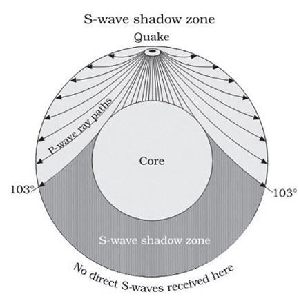
• The shadow zone of S-wave is much larger than that of the P-waves.
• It is also a little over 40 percent of the earth surface.
VOLCANISM
• Volcanism refers to an exogenous activity which includes the formation of magma, its upward movement, ejection of magma (lava) on the earth s surface, and its cooling and solidification.
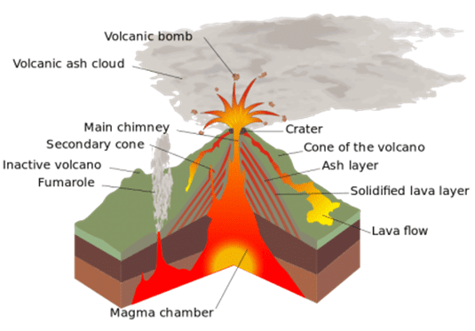
Magma and Lava
• Magma refers to the molten rock material present inside the earth in the asthenosphere.
• When this molten material comes out to the Earth’s surface through an opening of a volcano, it is known as the Lava.
• The process through which this molten material or magma comes out from asthenosphere to the Earth’s surface is known as volcanism.
Types of volcanic eruptions
• Ejection of Lava to the surface occurs through either Fissure eruption or through Central eruption.
Fissure eruption
• In Fissure volcanic eruptions, the Lava comes out to the surface through the cracks of the rock strata and hence the fissure eruptions are not much explosive.
• The fissure eruptions are smooth and the Lava spreads to a larger area, so they form landscapes such as plateaus etc.
Central eruption
• In the central volcanic eruptions, the lava comes out to the surface through narrow pipes and thus causes an explosion, during the ejection of magma onto the surface.
• The explosive nature of eruptions leads to the formation of mountains which are known as volcanic mountains.
• The different volcanic Islands throughout the world are actually volcanic mountains formed through Central eruptions
Causes of volcanic eruptions
• In the interior of the earth, the radioactive substances undergo chemical reactions which generate a large amount of heat. Apart from this, some amount of residual heat which was captured at the centre of the earth during its formation is also present.
• This leads to a creation of large temperature difference between the inner and Outer layers of earth.
• This huge temperature difference leads to the formation of convection currents in the outer Core and the Mantle. Due to this, the molten magma along with the gaseous materials comes out to the earth s surface at the first available opportunity.
• This mainly occurs in the weak zones of earth surface such as divergent plate boundaries, and convergent plate boundaries etc.
• Sometimes, the earthquakes may expose the fault zones in the rock strata through which the Magma can escape to the earth s surface leading to volcanic eruptions.
Major types of volcanoes
• Volcanoes are classified on the basis of nature of eruption and the form developed at the surface.
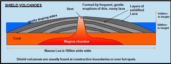
Shield Volcanoes
• The Shield volcanoes are the largest of all the volcanoes on the earth, which are not steep.
• These volcanoes are mostly made up of basalt.
• They become explosive if in some way water gets into the vent, otherwise, they are characterized by low-explosivity.
• The lava that is moving upwards does so in a fountain-form and emanates the cone at the vent’s top and then develops into cinder cone.
• Eg: Hawaiian shield volcanoes
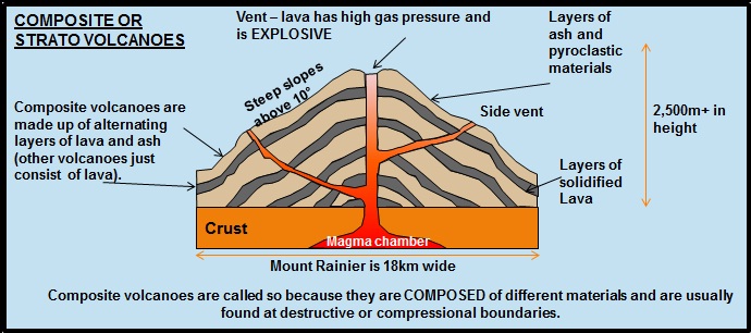
Composite Volcanoes
• Composite Volcanoes are characterized by outbreaks of cooler and more viscous lavas than basalt.
• They are constructed from numerous explosive eruptions.
• Large quantities of pyroclastic material and ashes find their way to the ground along with lava.
• This material gathers near the vent openings resulting in the creation of layers.
• Mayon Volcano in the Philippines, Mount Fuji in Japan, and Mount Rainier in Washington are the major composite volcanoes in the world.
• The major composite volcano chains are Pacific Rim which known as the “Rim of Fire”.
Caldera
• Calderas are known as the most explosive volcanoes of Earth.
• They are generally explosive in nature.
• When they erupt, they incline to collapse on themselves rather than constructing any structure.
• The collapsed depressions are known as calderas.

Flood Basalt Provinces
• Flood Basalt Province volcanoes discharge highly fluid lava that flows for long distances.
• Many parts of the world are covered by thick basalt lava flows.
Mid-Ocean Ridge Volcanoes
• These volcanoes are found in the oceanic areas.
• There exists a system of mid-ocean ridges stretching for over 70000 km all through the ocean basins.
• The central region of this ridge gets frequent eruptions.
Types of Lava in volcanism
Acidic or Andesitic or Composite Lava
- The acidic or composite Lava is highly viscous and has a high melting point. It has a high percentage of silica content, low density and light colour.
- The acidic lava flows slowly and they rarely travel far before solidification. This leads to the formation of the cone-like structure having steep sides.
- Due to the rapid solidification of this acidic Lava, the openings obstruct the flow of new Lava, which results in loud explosions and pyroclasts (volcanic bombs).
Basic or Shield or Basaltic Lava
- The basaltic or basic lava is highly fluid, and their temperature is about 1,000 C. Basaltic lava is poor in silica, but are rich in Iron and manganese.
- They have a dark colour and high fluidity. Due to their high fluidity, the basaltic Lava is not very explosive, and they spread over great distances as thin sheets of Lava.
- The volcano formed by Basic Lava is gently sloping and they form a flattened shield or dome with a wide diameter.
Active, Dormant and Extinct volcanoes
• The volcanoes erupting fairly frequently are known as active volcanoes.
• Kilauea volcano of Hawaii and Etna volcano in Italy etc. are examples of active volcanoes which have been volcanoes erupting in the recent past.
• Those volcanoes in which the eruption has not taken place regularly in the recent past are known as dormant volcanoes.
• The volcanoes erupting after undergoing long intervals of repose are the dormant volcanoes. The Fujiyama volcano of Japan, Krakatoa volcano of Indonesia and the Narcondam island volcano of Andaman and Nicobar islands are the examples of dormant volcanoes.
• Extinct volcanoes are those where the volcanic eruption had taken place in historic times but they are not active today.
• Mount Chimborazo in Ecuador, Mount Kenya in Eastern Africa, and Popa in Myanmar etc. are the examples of extinct volcanoes.
Hot springs and Geysers
• When the underground water which percolates down through the porous rocks is subjected to the heat of the underlying rock strata which is in the contact of hot magma it gives rise to geysers and hot springs.
• When the water comes in contact with the intense heat of these rocks, it gets heated and rises in the form of capillaries and narrow roots through the porous rocks.
• When this heated water comes to the surface it undergoes expansion and gets converted into steam leading to the formation of geysers and springs.
- Geysers: when the heated water at high pressure comes out of the surface and bursts into steam, it is known as Geysers. In most of the cases, a carter like structure is formed at its mouth.
- Springs: When the hot water comes out to the surface in a smooth manner it is known as a spring.
• Most of the world’s geysers are found in the areas of Iceland, New Zealand and the Yellowstone National Park of USA. The hot springs and geysers of Japan and Hawaii are great tourist attractions.
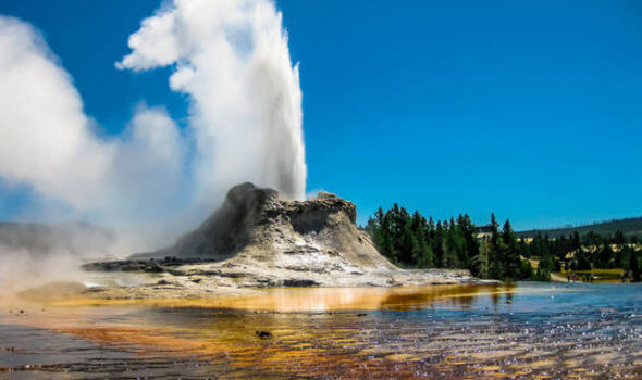
• Geysers are found in very few regions, while the hot water springs are found all over the world.
Distribution of the volcanoes around the world
• Till now, around 480 major active volcanoes have been found out of which around 400 are found in the areas around the Pacific Ocean. While the others are in the Alpine Himalayan belt, Atlantic Ocean, Indian Ocean etc. The Himalayas do not have an active volcano.
• The converging plate margins and the mid-oceanic ridges are the areas of high volcanic activity and earthquakes. The volcanic zones and earthquake zones are more prominent around the converging plate boundaries.
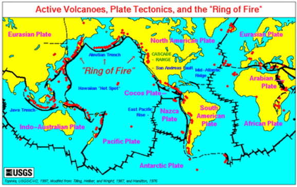
Pacific Ring of Fire
• The Circum-Pacific region or Pacific Ring of Fire has the largest concentration of active volcanoes. It has almost two-thirds of active volcanoes.
• The Aleutian islands of Kamchatka, Japan, the areas of Philippines, Indonesia, Islands of Solomon, Tonga and North Island, New Zealand, the Andes to Central America and up to Alaska are the part of Pacific rim of fire.
Volcanoes in India
• The Barren Island of Andaman and Nicobar Islands which is in the northeast of Port Blair is a volcanic island. The Barren Island volcano was the last active recently in 2017 and in 1991 and 1995.
• Narcondam which is in the north-east of Barren Island is another volcanic Island in India. Narcondam volcano has not been active in the recent past. Other parts of India do not have an active volcano.
Distribution of earthquakes
• The distribution of earthquakes in the world coincides closely with that of volcanoes. The Circum Pacific area, along with the Pacific Ring of Fire, is the region of greatest systemic activity with most frequent occurrences of earthquakes.
• These areas also have the most number of volcanic activity and Volcanic Islands. Around 70% of world’s total earthquakes take place in the Circum Pacific belt.
• Around 20% of earthquakes take place in the Mediterranean Himalayan belt which includes the Asia Minor, the Himalayas and the parts of north-western China.
• The earth’s crust is relatively stable in other parts of the world and they are less prone to the threat of earthquakes. However, no place in the world can be completely immune to the earthquakes.
Some important volcanic eruptions
Mount Vesuvius in Italy
• Mount Vesuvius is a composite volcano, which is around 4000 feet above the bay of Naples. The volcano erupted in AD 79 and buried the city of Pompeii located in the Southwest of this volcano. The volcanic ashes and the torrential rainfall afterwards buried the city and killed its inhabitants.
• Since the city was buried with the volcanic ashes, it was good infertility for the cultivation of crops. This tempted farmers to begin a settled life on the slopes of Mount Vesuvius. This volcano again erupted in December 1631 and destroyed around 15 towns and killed their inhabitants.
Mount Krakatoa in the Sunda Strait
• In August 1883, Mount Krakatoa located in the centre of the strait, between Java and Sumatra, exploded violently; this was one of the greatest volcanic explosions known to the mankind.
• The Krakatau Island was not inhabited, so nobody was killed due to the lava flows and ashes. However, it set up the Tsunami waves of over hundred feet high which submerged the coastal areas of Indonesia and drowned around 36000 people.
• It is one of the deadliest volcanic eruption in the recent human history which was responsible for the death of around 120,000 people. The volcano erupted on 10 April 1815 and was the most powerful volcanic eruption in the last 500 years. It sent volcanic ashes and gases like SO2 in the sky. It also led to the creation a series of Tsunami waves.
• Due to the emission of large amount of SO2, the world experienced large temperature drop which was responsible for the crop failures in various parts of the world. Thousands of people died due to starvation in China, while the price of grains quadrupled in Switzerland after 2 years of the volcanic eruption.
Volcanic Landforms
• Volcanic eruptions result in the formation of varied types of landforms.
• The lava that is discharged during volcanic eruptions on cooling develops into igneous rocks.
• The cooling may take place either on arriving on the surface or also while the lava is still in the crustal portion.
• Volcanic landforms are divided into extrusive and intrusive landforms based on whether magma cools within the crust or above the crust.
• Rocks formed by the cooling of magma within the crust are called Plutonic rocks.
• Rocks formed by the cooling of lava above the surface are called Igneous rocks.
• The lava that cools inside the crustal portions takes diverse forms. These forms are called intrusive forms.
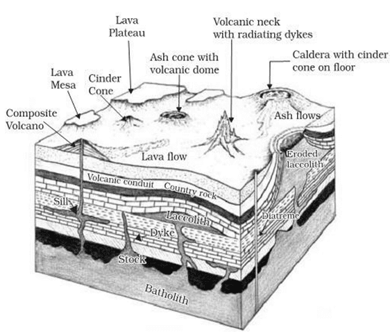
Batholiths
- Batholiths are the cooled portion of magma chambers.
- It is a large body of magmatic material that cools in the deeper depth of the crust moulds in the form of large domes.
- They appear on the surface only after the denudation processes eliminate the overlying materials.
- These are granitic bodies.
Laccoliths
- These are large dome-shaped intrusive bodies with a level base and linked by a pipe-like channel from below.
- It bears a similarity to the surface volcanic domes of the composite volcano, only these are located at deeper depths.
- It can be considered as the localized source of lava
- The Karnataka plateau is patterned with dome hills of granite rocks.
Lopolith
- When the lava moves upwards, a part of the same tends to move in a horizontal direction wherever it finds a weak plane.
- It can get rested in various forms. If it develops into a saucer shape, concave to the sky body, it is called lopolith.
Phacolith
- It is a wavy mass of intrusive rocks found at the base of synclines or at the top of the anticline in the folded igneous country.
- These wavy materials have a definite outlet to source beneath in the form of magma cavities.
Sills
- The near horizontal bodies of the intrusive igneous rocks are called sill
- The thick horizontal deposits are called sills whereas the thinner ones are called sheets.
Dykes
- Dykes are the most commonly found intrusive forms in the western Maharashtra area.
- When the lava makes its channel through cracks and the fissures, it solidifies almost perpendicular to the ground.
- This gets cooled in the same position to grow a wall-like structure. Such structures are known as dykes.
These are regarded as the feeders for the eruptions that led to the development of the Deccan traps.
Extrusive Volcanic Landforms
• Extrusive landforms are formed from material thrown out to the surface during volcanic activity.
• The materials thrown out include lava flows, pyroclastic debris, volcanic bombs, ash, dust and gases such as nitrogen compounds, sulphur compounds and minor amounts of chlorine, hydrogen and argon.
Fissure vent
• A fissure vent (volcanic fissure) is a narrow, linear volcanic vent through which lava erupts, usually without any explosive activity.
• The vent is often a few meters wide and may be many kilometres long.
• Fissure vents are common in basaltic volcanism (shield type volcanoes).
Conical vent
• A conical vent is a narrow cylindrical vent through which magma flows out violently.
• Conical vents are common in andesitic volcanism (composite or stratovolcano).
Mid-Ocean Ridges
• The system of mid-ocean ridges stretches for more than 70,000 km across all the ocean basins.
• The central portion of the mid-ocean ridges experiences frequent eruptions.
• The lava is basaltic (less silica and hence less viscous) and causes the spreading of the seafloor.
Composite Type Volcanic Landforms
• They are conical or central type volcanic landforms.
• Along with andesitic lava, large quantities of pyroclastic material and ashes find their way to the surface.
• Andesitic lava along with pyroclastic material accumulates in the vicinity of the vent openings leading to the formation of layers, and this makes the mounts appear as a composite volcano or a stratovolcano (divided into layers).
• The highest and most common volcanoes have composite cones.
• Mount Stromboli (the Lighthouse of the Mediterranean), Mount Vesuvius, Mount Fuji are examples.
Shield Type Volcanic Landforms
• The Hawaiian volcanoes are the most familiar examples.
• These volcanoes are mostly made up of basaltic lava (very fluid).
• These volcanoes are not steep.
• They become explosive if somehow water gets into the vent; otherwise, they are less explosive.
• Example: Hawaiian volcanoes Mauna Loa (active shield volcano) and Mauna Kea (dormant shield volcano).
Fissure Type Flood Basalt Landforms (Lava Plateaus)
• Sometimes, a very thin magma escapes through cracks and fissures in the earth’s surface and flows after intervals for a long time, spreading over a vast area, finally producing a layered, undulating (wave-like), flat surface.
• Example: Siberian Traps, Deccan Traps, Snake Basin, Icelandic Shield, Canadian Shield.
Lava Dome
• A lava dome (volcanic dome) is a mound-shaped protrusion (a structure that extends outside the surface) resulting from the slow extrusion (coming out) of viscous lava from a volcano.
• In Lava domes, viscous magma piles up around the vent.
• The magma does not have enough gas or pressure to escape, although sometime later after sufficient pressure builds up, it may erupt explosively.
Pseudo volcanic features
• Pseudo volcanic features are certain topographic features that resemble volcanic forms but are of non-volcanic origin. They include meteorite crater, salt plugs, and mud-volcanoes.
Meteorite Craters
• Meteorite craters are impact craters that are formed when a meteorite strikes the surface of the earth creating a huge depression.
Salt plug or salt dome
• A salt plug is formed when underground salt deposits at high pressure become ductile and pierce through the overlying sediments to create a diapir (a dome-like intrusion forced into brittle overlying rocks.
• Salt extrusions may take the form of salt hills which exhibit volcanic crater like features.
• Salt structures are impermeable and can lead to the formation of a stratigraphic trap (an impermeable layer capable of retaining hydrocarbons. Structural traps, in contrast, are cracks in faults and folds that can retain hydrocarbons).
Mud-volcanoes
• A mud volcano or mud dome is a landform created by the eruption of mud, water and gases.
• Mud-volcanoes have a similar shape to other types of volcanoes and contains several cones.
• They are usually found near the subduction zones and hot springs.
• Other mud volcanoes, entirely of a non-volcanic origin, occur near oil-fields where methane and other volatile hydrocarbon gases mixed with mud force their way upward.