FORESTS & NATURAL VEGETATION OF INDIA
Climate, soil and topography are the major factors that influence Natural Vegetation of a place.
The main climatic factors are rainfall and temperature. The amount of annual rainfall has a great bearing on the type of vegetation.
Annual Rainfall Type of Vegetation
200 cm or more Evergreen Rain Forests
100 to 200 cm Monsoon Deciduous Forests
50 to 100 cm Drier Deciduous or Tropical Savannah
25 to 50 cm Dry Thorny Scrub (Semi-arid)
Below 25 cm Desert (Arid)
Temperature is the major factor in Himalayas and other hilly regions with an elevation of more than 900 metres.
As the temperature falls with altitude in the Himalayan region the vegetal cover changes with altitude from tropical to sub-tropical, temperate and finally alpine.
Soil is an equally determining factor in few regions. Mangrove forests, swamp forests are some of the examples where soil is the major factor.
Topography is responsible for certain minor types e.g. alpine flora, tidal forests, etc..
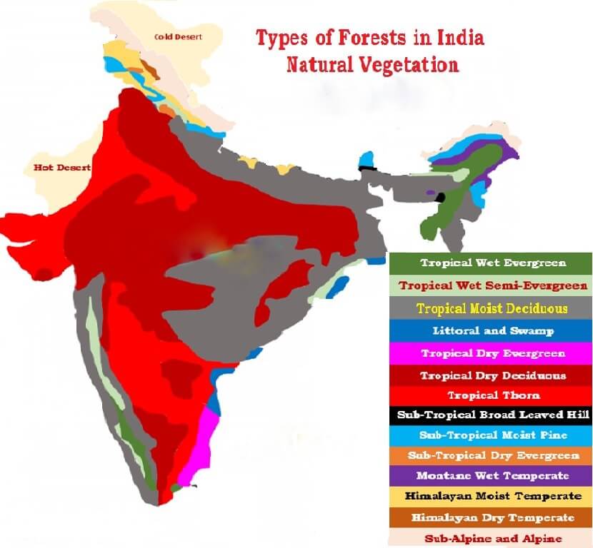
Classification of Natural Vegetation of India
Classification of Natural Vegetation of India is primarily based on spatial and annual variations in rainfall. Temperature, soil and topography are also considered.
India’s vegetation can be divided into 5 main types and 16 sub-types as given below.
A. Moist Tropical Forests
- Tropical Wet Evergreen
- Tropical Semi-Evergreen
- Tropical Moist Deciduous
- Littoral and Swamp
B. Dry Tropical Forests
- Tropical Dry Evergreen
- Tropical Dry Deciduous
- Tropical Thorn
C. Montane Sub-tropical Forests
- Sub-tropical broad leaved hill
- Sub-tropical moist hill (pine)
- Sub-tropical dry evergreen
D. Montane Temperate Forests
- Montane Wet Temperate
- Himalayan Moist Temperate
- Himalayan Dry Temperate
E. Alpine Forests
- Sub-Alpine
- Moist Alpine scrub
- Dry Alpine scrub
Forest Type in India % of Total Area
Tropical Moist Deciduous 37
Tropical Dry Deciduous 28
Tropical Wet Evergreen 8
Sub-Tropical Moist Hill 6
Tropical Semi-Evergreen 4
Rest below 4 %
1. Moist Tropical Forests
Tropical Wet Evergreen Forests or Rain Forests
Climatic Conditions
- Annual rainfall exceeds 250 cm
- The annual temperature is about 25°-27°C
- The average annual humidity exceeds 77 per cent and
- The dry season is distinctly short.
Characteristics
- Evergreen: Due to high heat and high humidity, the trees of these forests do not shed their leaves together.
- Mesosphytic: Plants adopted to neither too dry nor too wet type climate.
{What are mesophytes?
Unlike hydrophytic plants, such as water lily or pondweed, that grow in saturated soil or water, or xerophytic plants, such as cactus, that grow in extremely dry soil, mesophytes are ordinary plants that exist between the two extremes.
Mesophytic environments are marked by average to hot temperatures and soil that is neither too dry nor too wet.}
- Lofty: The trees often reach 45 – 60 metres in height
- Thick Canopy: From the air, the tropical rain forest appears like a thick canopy of foliage, broken only where it is crossed by large rivers or cleared for cultivation.
- All plants struggle upwards (most ephiphytes) for sunlight resulting in a peculiar layer arrangement. The entire morphology looks like a green carpet when viewed from above.
- Less undergrowth: The sun light cannot reach the ground due to thick canopy. The undergrowth is formed mainly of bamboos, ferns, climbers, orchids, etc.
Distribution
- Western side of the Western Ghats (500 to 1370 metres above sea level)
- Some regions in the Purvanchal hills
- In the Andaman and Nicobar Islands
Timber
- Hardwood: The timber of these forests is fine-grained, hard and durable
- It has high commercial value but it is highly challenging to exploit due to dense undergrowth, absence of pure stands and lack of transport facilities [Read previous posts on Climatic regions to understand how lumbering industry works in Equatorial Rainforests (hardwood) and Taiga Climatic (softwood) conditions].
- The important species of these forests are mahogany, mesua, white cedar, jamun, canes, bamboo etc.
Tropical Semi-Evergreen Forests
- They are transitional forests between tropical wet evergreen forests and tropical deciduous forests.
- They are comparatively drier areas compared to tropical wet evergreen forests.
Climatic Conditions
- Annual rainfall is 200-250 cm
- Mean annual temperature varies from 24°C to 27°C
- The relative humidity is about 75 per cent
- The dry season is not short like in tropical evergreen forests.
Distribution
- Western coast
- Assam
- Lower slopes of the Eastern Himalayas
- Odisha and
- Andamans
Characteristics
- The semi-evergreen forests are less dense.
- They are more gregarious [living in flocks or colonies – more pure stands] than the wet evergreen forests.
- These forests are characterized by many species.
- Trees usually have buttressed trunks with abundant epiphytes.
- The important species are laurel, rosewood, mesua, thorny bamboo – Western Ghats, white cedar, Indian chestnut, champa, mango, etc. – Himalayan region.
Timber
- Hardwood: Similar to that in tropical evergreen forests except that these forests are less dense with more pure stands
- So, timber industry here is better than in evergreen forests
Tropical Moist Deciduous Forests
- Climatic Conditions
- Annual rainfall 100 to 200 cm
- Mean annual temperature of about 27°C
- The average annual relative humidity of 60 to 75 per cent
- Spring (between winter and summer) and summer are dry
Characteristics
- The trees drop their leaves during the spring and early summer when sufficient moisture is not available
- The general appearance is bare in extreme summers (April-May)
- Tropical moist deciduous forests present irregular top storey [25 to 60 m]
- Heavily buttressed trees and fairly complete undergrowth
- These forests occupy a much larger area than the evergreen forests but large tracts under these forests have been cleared for cultivation
Distribution
- Belt running along the Western Ghats surrounding the belt of evergreen forests
- A strip along the Shiwalik range including Terai and Bhabar from 77° E to 88° E
- Manipur and Mizoram
- Hills of eastern Madhya Pradesh and Chhattisgarh
- Chota Nagpur Plateau
- Most of Odisha
- Parts of West Bengal and
- Andaman and Nicobar islands
Timber
- These provide valuable timer like Teak.
- The main species found in these forests are teak, sal, laurel, rosewood, amla, jamun, bamboo, etc.
- It is comparatively easy to exploit these forests due to their high degree of gregariousness (more pure stands).
Littoral and Swamp Forests
- They can survive and grow both in fresh as well as brackish water (The mixture of seawater and fresh water in estuaries is called brackish water and its salinity can range from 0.5 to 35 ppt).
- Occur in and around the deltas, estuaries and creeks prone to tidal influences (delta or tidal forests).
- Littoral (relating to or on the shore of the sea or a lake) forests occur at several places along the coast.
- Swamp forests are confined to the deltas of the Ganga, the Mahanadi, the Godavari, the Krishna and the Cauvery.
- Dense mangroves occur all along the coastline in sheltered estuaries, tidal creeks, backwaters, salt marshes and mudflats. It provides useful fuel wood.
- The most pronounced and the densest is the Sunderbans in the Ganga delta where the predominant species is Sundri (Heriteera)
Timber
- It provides hard and durable timber which is used for construction, building purposes and making boats.
- The important species found in these forests are Sundri, agar, rhizophora, screw pines, canes and palms, etc.
2. Dry Tropical Forests
Tropical Dry Evergreen Forests
Distribution
- Along the coasts of Tamil Nadu.
Climatic Conditions
Annual rainfall of 100 cm [mostly from the north-east monsoon winds in October – December]
Mean annual temperature is about 28°C.
The mean humidity is about 75 per cent.
The growth of evergreen forests in areas of such low rainfall is a bit strange.
Characteristics
Short statured trees, up to 12 m high, with complete canopy
Bamboos and grasses not conspicuous
The important species are jamun, tamarind, neem, etc.
Most of the land under these forests has been cleared for agriculture or casuarina plantations.
{Casuarina plantation
It resembles feathery conifer in general appearance.
They are rapid-growing, carefree species for sites and climates as varied as coastal sand dunes, high mountain slopes, hot humid tropics, and semi-arid regions.
They have the ability to fix atmospheric nitrogen. It grows 15 to 25 metres in height on an average.}
Distribution
Casuarina is the most popular farm forestry in the states of Andhra Pradesh, Tamil Nadu, West Bengal, Odisha, Maharashtra, Gujarat, and Karnataka.
Benefits
- Reduces damage in the event of natural calamities.
- Line planting in the coastal areas helps in controlling the wind force.
- It is also used for tourism promotion in view of its ornamental appearance.
- It provides top quality firewood.
- The wood is suitable for paper pulp and useful raw material for the manufacture of paper for writing, printing, and wrapping.
- It is got some serious medicinal values as well.
Wasteland development
- The characteristics which make it a suitable species for wasteland development include adaptability to wide range of habitats, fast growth, salt tolerant, drought resistant, ability to reclaim land and stabilize sand dunes.
- Intercrops such as groundnut, cucumber, watermelons, sesamum, and pulses can also be raised along with the plantation.
Tropical Dry Deciduous Forests
Climatic Conditions
- Annual rainfall is 100-150 cm.
Characteristics
- These are similar to moist deciduous forests and shed their leaves in dry season.
- The major difference is that they can grow in areas of comparatively less rainfall.
- They represent a transitional type – moist deciduous on the wetter side and thorn forests on the drier side.
- They have closed but uneven canopy.
- The forests are composed of a mixture of a few species of deciduous trees rising up to a height of 20 metres.
- Undergrowth: Enough light reaches the ground to permit the growth of grass and climbers.
Distribution
- They occur in an irregular wide strip running from the foot of the Himalayas to Kanniyakumari except in Rajasthan, Western Ghats and West Bengal.
- The important species are teak, axlewood, rosewood, common bamboo, red sanders, laurel, satinwood, etc.
- Large tracts of this forest have been cleared for agricultural purposes.
- These forests have suffer from over grazing, fire, etc.
Tropical Thorn Forests
Climatic Conditions
- Annual rainfall less than 75 cm.
- Humidity is less than 50 per cent.
- Mean temperature is 25°-30°C.
Characteristics
- The trees are low (6 to 10 metres maximum) and widely scattered.
- Acacias and Euphorbias are very prominent.
- The Indian wild date is common. Some grasses also grow in the rainy season.
Distribution
- Rajasthan, south-western Punjab, western Haryana, Kachchh and neighbouring parts of Saurashtra.
- Here they degenerate into desert type in the Thar desert.
- Such forests also grow on the leeside of the Western Ghats covering large areas of Maharashtra, Karnataka, Telangana, Andhra Pradesh and Tamil Nadu.
- The important species are neem, babul, cactii, etc.
3. Montane Sub-Tropical Forests
Sub-tropical Broad-leaved Hill Forests
Climatic conditions
- Mean annual rainfall is 75 cm to 125 cm.
- Average annual temperature is 18°-21°C.
- Humidity is 80 per cent.
Distribution
Eastern Himalayas to the east of 88°E longitude at altitudes varying from 1000 to 2000 m.
Characteristics
- Forests of evergreen species
- Commonly found species are evergreen oaks, chestnuts, ash, beech, sals and pines
- Climbers and epiphytes [a plant that grows non-parasitically on a tree or other plant] are common
- These forests are not so distinct in the southern parts of the country. They occur only in the Nilgiri and Palni hills at 1070-1525 metres above sea level.
- It is a “stunted rain-forest” and is not so luxuriant as the true tropical evergreen.
- The higher parts of the Western Ghats such as Mahabaleshwar, the summits of the Satpura and the Maikal Range, highlands of Bastar and Mt. Abu in the Aravali Range carry sub-types of these forests.
Sub-tropical Moist Pine Forests
Distribution
- Western Himalayas between 73°E and 88°E longitudes at elevations between 1000 to 2000 metres above sea level.
- Some hilly regions of Arunachal Pradesh, Manipur, Naga Hills and Khasi Hills.
Timber
- Chir or Chil is the most dominant tree which forms pure stands.
- It provides valuable timber for furniture, boxes and buildings.
- It is also used for producing resin and turpentine.
Sub-tropical Dry Evergreen Forests
Distribution
- Found in the Bhabar, the Shiwaliks and the western Himalayas up to about 1000 metres above sea level.
Climatic Conditions
- Annual rainfall is 50-100 cm (15 to 25 cm in December-March).
- The summers are sufficiently hot and winters are very cold.
Characteristics
- Low scrub forest with small evergreen stunted trees and shrubs.
- Olive, acacia modesta and pistacia are the most predominant species.
4. Montane Temperate Forests
Montane Wet Temperate Forests
Climatic Conditions
- Grows at a height of 1800 to 3000 m above sea level
- Mean annual rainfall is 150 cm to 300 cm
- Mean annual temperature is about 11°C to 14°C and the
- Average relative humidity is over 80 per cent.
Distribution
- Higher hills of Tamil Nadu and Kerala, in the Eastern Himalayan region.
Characteristics
- These are closed evergreen forests. Trunks have large girth.
- Branches are clothed with mosses, ferns and other epiphytes.
- The trees rarely achieve a height of more than 6 metres.
- Deodar, Chilauni, Indian chestnut, birch, plum, machilus, cinnamomum, litsea, magnolia, blue pine, oak, hemlock, etc. are important species.
Himalayan Moist Temperate Forests
Climatic Conditions
- Annual rainfall varies from 150 cm to 250 cm
Distribution
- Occur in the temperate zone of the Himalayas between 1500 and 3300 metres.
Cover the entire length of this mountain range in Kashmir, Himachal Pradesh, Uttarakhand, Darjeeling and Sikkim.
Characteristics
- Mainly composed of coniferous species
- Species occur in mostly pure strands
- Trees are 30 to 50 m high
- Pines, cedars, silver firs, spruce, etc. are most important trees
- They form high but fairly open forest with shrubby undergrowth including oaks, rhododendrons and some bamboos
Timber
- It provides fine wood which is of much use for construction, timber and railway sleepers.
Himalayan Dry Temperate Forests
Climatic Conditions
- Precipitation is below 100 cm and is mostly in the form of snow.
Characteristics
- Coniferous forests with xerophytic shrubs in which deodar, oak, ash, olive, etc are the main trees.
Distribution
- Such forests are found in the inner dry ranges of the Himalayas where south-west monsoon is very feeble.
- Such areas are in Ladakh, Lahul, Chamba, Kinnaur, Garhwal and Sikkim.
5. Alpine Forests
- Altitudes ranging between 2,900 to 3,500.
- These forests can be divided into: (1) sub-alpine; (2) moist alpine scrub and (3) dry alpine scrub.
- The sub-alpine forests occur lower than alpine scrubs and grasslands.
- It is a mixture of coniferous and broad-leaved trees in which the coniferous trees attain a height of about 30 m while the broad leaved trees reach only 10 m.
- Fir, spruce, rhododendron, etc. are important species.
- The moist alpine scrub is a low evergreen dense growth of rhododendron, birch etc. which occurs from 3,000 metres and extends upto snowline.
- The dry alpine scrub is the uppermost limit of scrub xerophytic, dwarf shrubs, over 3,500 metres above sea level and found in dry zone. Juniper, honeysuckle, artemesia etc. are important species
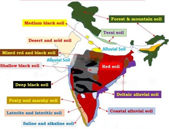
MAJOR SOIL TYPES OF INDIA
Geologically, Indian soils can broadly be divided into soils of peninsular India and soils of extra-peninsular India.
The soils of Peninsular India are formed by the decomposition of rocks in situ, i.e. directly from the underlying rocks.
Soils of Peninsular India are transported and re-deposited to a limited extent and are known as sedentary soils.
The soils of the Extra-Peninsula are formed due to the depositional work of rivers and wind. They are very deep. They are often referred to as transported or azonal soils.
Major groups:
- Alluvial soils
- Black soils
- Red soils
- Laterite and Lateritic soils
- Forest and Mountain soils
- Arid and Desert soils
- Saline and Alkaline soils and
- Peaty and Marshy soils
Alluvial Soils
Alluvial soils are formed mainly due to silt deposited by Indo-Gangetic-Brahmaputra rivers. In coastal regions some alluvial deposits are formed due to wave action.
Rocks of the Himalayas form the parent material. Thus the parent material of these soils is of transported origin.
They are the largest soil group covering about 15 lakh sq km or about 46 per cent of the total area.
They support more than 40% of the India’s population by providing the most productive agricultural lands.
Characteristics of Alluvial Soils
They are immature and have weak profiles due to their recent origin.
Most of the soil is Sandy and clayey soils are not uncommon.
Pebbly and gravelly soils are rare. Kankar (calcareous concretions) beds are present in some regions along the river terraces.
The soil is porous because of its loamy (equal proportion of sand and clay) nature.
Porosity and texture provide good drainage and other conditions favorable for agriculture.
These soils are constantly replenished by the recurrent floods.
Chemical properties of Alluvial Soils
The proportion of nitrogen is generally low.
The proportion of Potash, phosphoric acid and alkalies are adequate
The proportion of Iron oxide and lime vary within a wide range.
Distribution of Alluvial Soils in India
They occur all along the Indo-Gangetic-Brahmaputra plains except in few places where the top layer is covered by desert sand.
They also occur in deltas of the Mahanadi, the Godavari, the Krishna and the Cauvery, where they are called deltaic alluvium (coastal alluvium)
Some alluvial soils are found in the Narmada, Tapi valleys and Northern parts of Gujarat.
Crops in Alluvial Soils
They are mostly flat and regular soils and are best suited for agriculture.
They are best suited to irrigation and respond well to canal and well/tube-well irrigation.
They yield splendid crops of rice, wheat, sugarcane, tobacco, cotton, jute, maize, oilseeds, vegetables and fruits.
Geological divisions of alluvial soils
Geologically, the alluvium of the Great plain of India is divided into newer or younger khadar and older bhangar soils.
Bhabar
The bhabar belt is about 8-16 km wide running along the Shiwalik foothills. It is a porous, northern most stretch of Indo-Gangetic plain.
Rivers descending from the Himalayas deposit their load along the foothills in the form of alluvial fans. These alluvial fans (often pebbly soils) have merged together to build up the bhabar belt.
The porosity of bhabar is the most unique feature. The porosity is due to deposition of huge number of pebbles and rock debris across the alluvial fans.
The streams disappear once they reach the bhabar region because of this porosity. Therefore, the area is marked by dry river courses except in the rainy season.
The area is not suitable for agriculture and only big trees with large roots thrive in this belt.
Terai
Terai is an ill-drained, damp (marshy) and thickly forested narrow tract (15-30 km wide) to the south of Bhabar running parallel to it.
The underground streams of the Bhabar belt re-emerge in this belt. It is a swampy lowland with silty soils.
The terai soils are rich in nitrogen and organic matter but are deficient in phosphate.
These soils are generally covered by tall grasses and forests but are suitable for a number of crops such as wheat, rice, sugarcane, jute etc..
This thickly forested region provides shelter to a variety of wild life.
Bhangar
The Bhangar is the older alluvium along the river beds forming terraces higher than the flood plain (about 30 metres above the flood level).
It is of a more clayey composition and is generally dark colored.
A few metres below the terrace of the bhangar are beds of lime nodules known as “Kankar”.
Khadar
The Khadar is composed of newer alluvium and forms the flood plains along the river banks.
The banks are flooded almost every year and a new layer of alluvium is deposited with every flood. This makes them the most fertile soils of Ganges.
They are sandy clays and loams, more dry and leached, less calcareous and carbonaceous (less kankary). A new layer of alluvium is deposited by river flood almost every year.
Black Soils
The parent material for most of the black soil are the volcanic rocks that were formed in the Deccan Plateau (Deccan and the Rajmahal trap).
In Tamil Nadu, gneisses and schists form the parent material. The former are sufficiently deep while the later are generally shallow.
These are the region of high temperature and low rainfall. It is, therefore, a soil group typical to the dry and hot regions of the Peninsula.
Characteristics of Black Soils
A typical black soil is highly argillaceous [Geology (of rocks or sediment) consisting of or containing clay] with a large clay factor, 62 per cent or more.
In general, black soils of uplands are of low fertility while those in the valleys are very fertile.
The black soil is highly retentive of moisture. It swells greatly on accumulating moisture. Strenuous effort is required to work on such soil in rainy season as it gets very sticky.
In summer, the moisture evaporates, the soil shrinks and is seamed with broad and deep cracks. The lower layers can still retain moisture. The cracks permits oxygenation of the soil to sufficient depths and the soil has extraordinary fertility.
Colour of Black Soils
The black colour is due to the presence of a small proportion of titaniferous magnetite or iron and black constituents of the parent rock.
In Tamil Nadu and parts of Andhra Pradesh, the black colour is derived from crystalline schists and basic gneisses.
Various tints of the black colour such as deep black, medium black, shallow black , a mixture of red and black may be found in this group of soils.
Chemical Composition of Black Soils
10 per cent of alumina
9-10 per cent of iron oxide
6-8 per cent of lime and magnesium carbonates
Potash is variable (less than 0.5 per cent) and phosphates, nitrogen and humus are low
Distribution of Black Soils
Spread over 46 lakh sq km (16.6 per cent of the total area) across Maharashtra, Madhya Pradesh, parts of Karnataka, Telangana, Andhra Pradesh, Gujarat and Tamil Nadu.
Crops in Black Soils
These soils are best suited for cotton crop. Hence these soils are called as regur and black cotton soils.
Other major crops grown on the black soils include wheat, jowar, linseed, virginia tobacco, castor, sunflower and millets.
Rice and sugarcane are equally important where irrigation facilities are available.
Large varieties of vegetables and fruits are also successfully grown on the black soils.
This soil has been used for growing a variety of crops for centuries without adding fertilizers and manures, with little or no evidence of exhaustion.
Red Soils
Red soils along with its minor groups form the largest soil group of India.
The main parent rocks are crystalline and metamorphic rocks like acid granites, gneisses and quartzites.
Characteristics of Red Soils
The texture of these soils can vary from sand to clay, the majority being loams.
On the uplands, the red soils are poor, gravelly, and porous. But in the lower areas they are rich, deep dark and fertile.
Chemical Composition of Red Soils
They are acidic mainly due to the nature of the parent rocks. The alkali content is fair.
They are poor in lime, magnesia, phosphates, nitrogen and humus.
They are fairly rich in potash and potassium.
Color of Red Soils
The red colour is due to the presence of iron oxide.
When limestone, granites, gneisses and quartzites are eroded the clay enclosed within the rocks remains intact with other forms of non-soluble materials.
In oxidizing conditions, rust or iron oxide develops in the clay, when the soil is present above the water table giving the soil a characteristic red colour.
The colour is more due to the wide diffusion rather than high percentage of iron oxide content.
Distribution of Red Soils
These soils mostly occur in the regions of low rainfall.
They occupy about 3.5 lakh sq km (10.6 per cent) of the total area of the country.
These soils are spread on almost the whole of Tamil Nadu.
Other regions with red soil include parts of Karnataka, south-east of Maharashtra, Telangana, Andhra Pradesh, Madhya Pradesh, Chhattisgarh, Odisha, Chota Nagpur plateau; parts of south Bihar, West Bengal, Uttar Pradesh; Aravalis and the eastern half of Rajasthan (Mewar or Marwar Plateau), parts of North-Eastern states.
Crops in Red Soils
The red soils are mostly loamy and hence cannot retain water like the black soils.
The red soils, with the proper use of fertilizers and irrigation techniques, give good yield of cotton, wheat, rice, pulses, millets, tobacco, oil seeds, potatoes and fruits.
Laterite – Lateritic Soils
Laterite soils are mostly the end products of weathering.
They are formed under conditions of high temperature and heavy rainfall with alternate wet and dry periods.
Heavy rainfall promotes leaching (nutrients gets washed away by water) of soil whereby lime and silica are leached away and a soil rich in oxides of iron and aluminium compounds is left behind.
‘Laterite’ means brick in Latin. They harden greatly on loosing moisture.
Laterite soils are red in colour due to little clay and more gravel of red sand-stones.
Chemical composition of Laterite – Lateritic Soils
Laterite soils are rich in bauxite or ferric oxides.
They are very poor in lime, magnesia, potash and nitrogen.
Sometimes, the phosphate content may be high in the form of iron phosphate.
In wetter places, there may be higher content of humus.
Distribution of Laterite – Lateritic Soils
Laterite soils cover an area of 2.48 lakh sq km.
Continuous stretch of laterite soil is found on the summits of Western Ghats at 1000 to 1500 m above mean sea level, Eastern Ghats, the Rajmahal Hills, Vindhyan, Satpuras and Malwa Plateau.
They also occur at lower levels and in valleys in several other parts of the country.
They are well developed in south Maharashtra, parts of Karnataka etc. and are widely scattered in other regions.
Crops in Laterite – Lateritic Soils
Laterite soils lack fertility due to intensive leaching.
When manured and irrigated, some laterites are suitable for growing plantation crops like tea, coffee, rubber, cinchona, coconut, arecanut, etc.
In some areas, these soils support grazing grounds and scrub forests.
Economic value of Laterite – Lateritic Soils
Laterite and lateritic soils provide valuable building material.
These soils can be easily cut into cakes but hardens like iron when exposed to air.
As it is the end-product of weathering, it cannot be weathered much further and is durable.
Forest – Mountain Soils
These soils occupy about 2.85 lakh sq km or 8.67% of the total land area of India.
They are mainly heterogeneous soils found on the hill slopes covered by forests.
The formation of these soils is mainly governed by the characteristic deposition of organic matter derived from forests and their character changes with parent rocks, ground-configuration and climate.
Consequently, they differ greatly even if they occur in close proximity to one another.
Distribution of Forest – Mountain Soils
In the Himalayan region, such soils are mainly found in valleys, less steep and north facing slopes. The south facing slopes are very steep and exposed to denudation and hence do not support soil formation.
Forest soils occur in Western and Eastern Ghats also.
Chemical properties of Forest – Mountain Soils
The forest soils are very rich in humus.
They are deficient in potash, phosphorus and lime.
They require good deal of fertilizers for high yields.
Crops in Forest – Mountain Soils
They are suitable for plantations of tea, coffee, spices and tropical fruits in peninsular forest region.
Wheat, maize, barley and temperate fruits are grown in the Himalayan forest region.
Arid – Desert Soils
The desert soils consist of Aeolian sand (90 to 95 per cent) and clay (5 to 10 per cent).
They cover a total area of 1.42 lakh sq km (4.32%).
The presence of sand inhibits soil growth. Desertification of neighboring soils is common due to intrusion of desert sand under the influence of wind [Aeolian sand].
Distribution of Arid – Desert Soils
Occur in arid and semi-arid regions of Rajasthan, Punjab and Haryana. The sand here is blown from the Indus basin and the coast by the prevailing south-west monsoon winds.
Sandy soils without clay factor are also common in coastal regions of Odisha, Tamil Nadu and Kerala.
Chemical properties of Arid – Desert Soils
They are usually poor in organic matter.
Some desert soils are alkaline with varying degree of soluble salts like calcium carbonate.
Calcium content increases downwards and the subsoil has ten times more calcium.
The phosphate content of these soils is as high as in normal alluvial soils.
Nitrogen is originally low but some of it is available in the form of nitrates.
Crops of Arid – Desert Soils
Phosphates and nitrates make these soil fertile wherever moisture is available.
There is a possibility of reclaiming these soils if proper irrigation facilities are available.
In large areas, only the drought resistant and salt tolerant crops such as barley, cotton, millets, maize and pulses are grown.
Saline – Alkaline Soils
In Saline and Alkaline Soils, the top soil is impregnated (soak or saturate with a substance) with saline and alkaline efflorescences (become covered with salt particles).
Undecomposed rock fragments, on weathering, give rise to sodium, magnesium and calcium salts and sulphurous acid.
Some of the salts are transported in solution by the rivers.
In regions with low water table, the salts percolate into sub soil and in regions with good drainage, the salts are wasted away by flowing water.
But in places where the drainage system is poor, the water with high salt concentration becomes stagnant and deposits all the salts in the top soil once the water evaporates.
In regions with high sub-soil water table, injurious salts are transferred from below by the capillary action as a result of evaporation in dry season.
Capillary action
Capillary action is the ability of a liquid to flow in narrow spaces without the assistance of, and in opposition to, external forces like gravity.
The force behind capillary action is surface tension.
Distribution of Saline – Alkaline Soils
Saline and Alkaline Soils occupy 68,000 sq km of area.
These soils are found in canal irrigated areas and in areas of high sub-soil water table.
Parts of Andhra Pradesh, Telangana, Karnataka, Bihar, Uttar Pradesh, Haryana, Punjab (side effects of improper or excess irrigation), Rajasthan and Maharashtra have this kind of soils.
The accumulation of these salts makes the soil infertile and renders it unfit for agriculture.
In Gujarat, the areas around the Gulf of Khambhat are affected by the sea tides carrying salt-laden deposits. Vast areas comprising the estuaries of the Narmada, the Tapi, the Mahi and the Sabarmati have thus become infertile.
Along the coastline, saline sea waters infiltrate into coastal regions during storm surges (when cyclones make landfall) and makes the soil unfit for cultivation. The low lying regions of coastal Andhra Pradesh and Tamil Nadu face this kind of soil degradation.
Peaty – Marshy Soils
These are soils with large amount of organic matter and considerable amount of soluble salts.
The most humid regions have this type of soil.
They are black, heavy and highly acidic.
Distribution of Peaty – Marshy Soils
Kottayam and Alappuzha districts of Kerala where it is called kari.
Also occur in the coastal areas of Odisha and Tamil Nadu, Sunderbans of West Bengal, in Bihar and Almora district of Uttarakhand.
Chemical Properties of Peaty – Marshy Soils
They are deficient in potash and phosphate.
Crops of Peaty – Marshy Soils
Most of the peaty soils are under water during the rainy season but as soon the rains cease, they are put under paddy cultivation.
Characteristics of Indian Soils
Most soils are old and mature. Soils of the peninsular plateau are much older than the soils of the great northern plain.
Indian soils are largely deficient in nitrogen, mineral salts, humus and other organic materials.
Plains and valleys have thick layers of soils while hilly and plateau areas depict thin soil cover.
Some soils like alluvial and black soils are fertile while some other soils such as laterite, desert and alkaline soils lack in fertility and do not yield good harvest.
Indian soils have been used for cultivation for hundreds of years and have lost much of their fertility.
Problems of Indian Soils
Soil erosion (Himalayan region, Chambal Ravines etc.), deficiency in fertility (Red, lateritic and other soils), desertification (around Thar desert, rain-shadow regions like parts of Karnataka, Telangana etc.), waterlogging (Punjab-Haryana plain) salinity and alkalinity (excessively irrigated regions of Punjab, Haryana, Karnataka etc.), wasteland, over exploitation of soils due to increase in population and rise in living standards and encroachment of agricultural land due to urban and transport development.
DEMOGRAPHICS OF INDIA
What is the census?
Census is nothing but a process of collecting, compiling, analyzing, evaluating, publishing and disseminating statistical data regarding the population. It covers demographic, social and economic data and are provided as of a particular date.
When was the first census in India held?
Census operations started in India long back during the period of the Maurya dynasty. It was systematized during the years 1865 to 1872, though it has been conducted uninterruptedly from the year 1881 being a trustworthy resource of information.
Why is the census important?
1. The Indian Census is the most credible source of information on Demography (Population characteristics), Economic Activity, Literacy and Education, Housing & Household Amenities, Urbanisation, Fertility and Mortality, Scheduled Castes and Scheduled Tribes, Language, Religion, Migration, Disability and many other socio-cultural and demographic data since 1872. Census 2011 is the 15th National Census of the Country. This is the only source of primary data in the village , town and ward level, It provides valuable information for planning and formulation policies for Central and the State Governments and is widely used by National and International Agencies, scholars, business people, industrialists, and many more.
2. The delimitation/reservation of Constituencies – Parliamentary/Assembly/Panchayats and other Local Bodies is also done on the basis of the demographic data thrown up by the Census. Census is the basis for reviewing the country’s progress in the past decade, monitoring the ongoing Schemes of the Government and most importantly, plan for the future.
Key findings of 2011 census
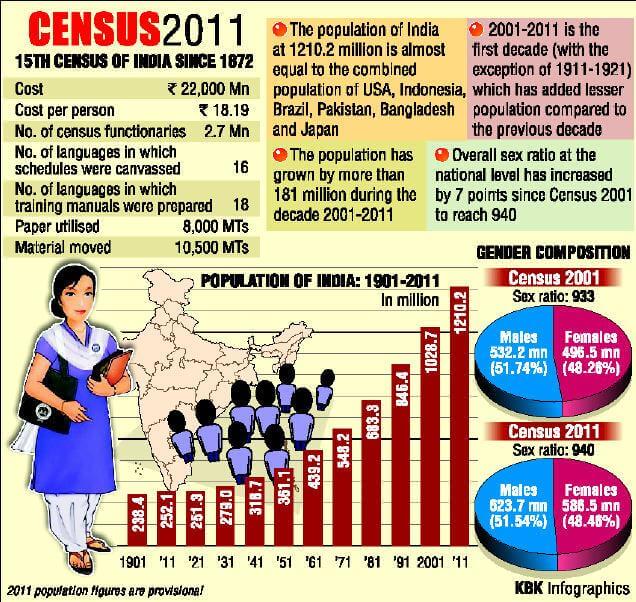
1. Population
India’s total population stands at 1.21 billion, which is 17.7 per cent more than the last decade, and growth of females was higher than that of males.
There was an increase of 90.97 million males and increase of 90.99 million females. The growth rate of females was 18.3 per cent which is higher than males — 17.1 per cent. India’s population grew by 17.7 per cent during 2001-11, against 21.5 per cent in the previous decade.
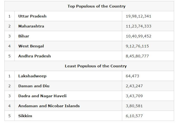
Among the major states, highest decadal growth in population has been recorded in Bihar (25.4 per cent) while 14 states and Union Territories have recorded population growth above 20 per cent.
2. Rural and urban population
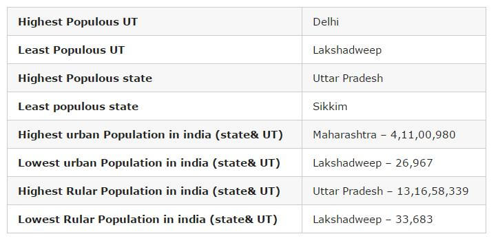
Altogether, 833.5 million persons live in rural area as per Census 2011, which was more than two-third of the total population, while 377.1 million persons live in urban areas. Urban proportion has gone up from 17.3 per cent in 1951 to 31.2 per cent in 2011.
Empowered Action Group (EAG) states have lower urban proportion (21.1 per cent) in comparison to non-EAG states (39.7 per cent).
Highest proportion of urban population is in NCT Delhi (97.5 per cent). Top five states in share of urban population are Goa (62.2 per cent), Mizoram (52.1 per cent), Tamil Nadu (48.4 per cent), Kerala (47.7 per cent) and Maharashtra (45.2 per cent).
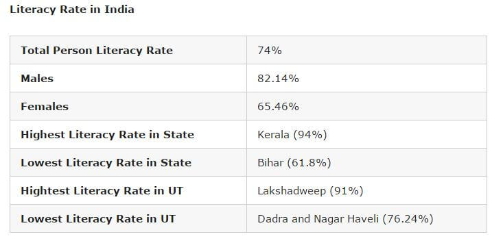
3. Literacy
Literacy rate in India in 2011 has increased by 8 per cent to 73 per cent in comparison to 64.8 per cent in 2001.
While male literacy rate stands at 80.9 per cent – which is 5.6 per cent more than the previous census, the female literacy rate stands at 64.6 per cent — an increase of 10.9 per cent than 2001.
The highest increase took place in Dadra and Nagar Haveli by 18.6 points (from 57.6 per cent to 76.2 per cent), Bihar by 14.8 points (from 47.0 per cent to 61.8 per cent), Tripura by 14.0 points (from 73.2 per cent to 87.2 per cent)
Improvement in female literacy is higher than males in all states and UTs, except Mizoram (where it is same in both males and females) during 2001-11.
The gap between literacy rate in urban and rural areas is steadily declining in every census. Gender gap in literacy rate is steadily declining in every census. In Census 2011, the gap stands at 16.3 points.
Top five states and UTs, where literacy rate is the highest, are Kerala (94 per cent), Lakshadweep (91.8 per cent), Mizoram (91.3 per cent), Goa (88.7 per cent) and Tripura (87.2).
The bottom five states and UTs are Bihar (61.8 per cent), Arunachal Pradesh (65.4 per cent), Rajasthan (66.1 per cent), Jharkhand (66.4 per cent) and Andhra Pradesh (67 per cent).
4. Density
The density of population in the country has also increased from 325 in 2001 to 382 in 2011 in per sq km. Among the major states, Bihar occupies the first position with a density of 1106, surpassing West Bengal which occupied the first position during 2001.
Delhi (11,320) turns out to be the most densely inhabited followed by Chandigarh (9,258), among all states and UT’s, both in 2001 and 2011 Census. The minimum population density works out in Arunachal Pradesh (17) for both 2001 and 2011 Census.
5. Sex ratio
The sex ratio of population in the country in 2011 stands at 940 female against 1000 males, which is 10 per cent more than the last census when the number female per thousand male stood at 933. Haryana has the dubious distinction of having the worst male-female ratio among all states while Kerala fares the best.
The number of females per 1000 males in Haryana in 2011 stands at 879 followed by Jammu and Kashmir (889 female) and Punjab (895 females).
The other two worst-performing states in terms of skewed sex ration are Uttar Pradesh (912 females) and Bihar (918 females).
Five top performing states in terms of sex ratio were Kerala (1,084 females), Tamil Nadu (996), Andhra Pradesh (993), Chhattisgarh (991), Odisha (979).
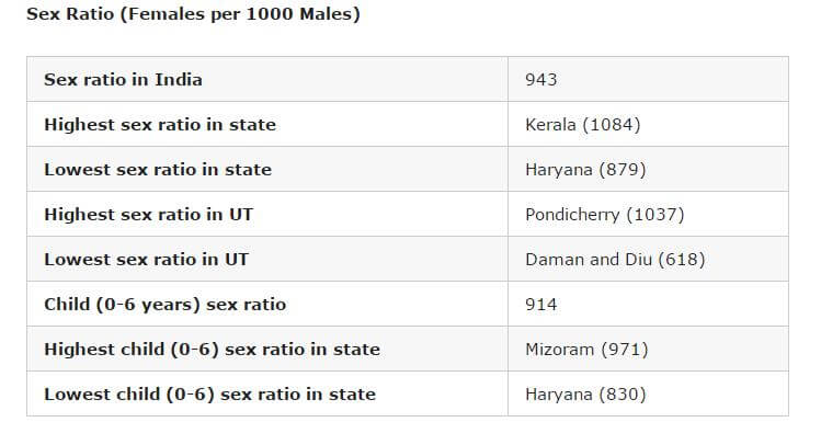
6. Child population
Child population in the age of 0 to 6 years has seen an increase of 0.4 per cent to 164.5 million in 2011 from 163.8 million in 2001.
The child population (0-6) is almost stationary. In 17 states and UTs, the child population has declined in 2011 compared to 2001.
With the declaration of sex ratio in the age group 0-6, the Census authorities tried to bring out the recent changes in the society in its attitude and outlook towards the girl child. It was also an indicator of the likely future trends of sex ratio in the population.
There has been a decline of 8 per cent in the sex ratio of 0-6 age group. In 2011, the child sex ratio (0-6) stands at 919 female against 1000 male in comparison to 927 females in 2001.
Male child (0-6) population has increased whereas female child population has decreased during 2001-11. Eight states, Jammu and Kashmir, Rajasthan, Uttar Pradesh, Bihar, Jharkhand, Arunachal Pradesh, Mizoram, and Meghalaya have proportion of child population more than 15 per cent.
The worst performing states in regard to sex ration in the age group of 0 to 6 years are Haryana (834 females), Punjab (846), Jammu and Kashmir (862), Rajasthan (888) and Gujarat (890).
The best performing states are Chhattisgarh (969), Kerala (964), Assam (962), West Bengal (956) Jharkhand (948) and Karnataka (948).
7. SC/ST data
According to the Census, Scheduled Castes are notified in 31 states and UTs and Scheduled Tribes in 30 states. There are altogether 1,241 individual ethnic groups, etc. notified as SC’s in different states and UT’s.
The number of individual ethnic groups, etc. notified as ST’s is 705. There has been some changes in the list of SC’s/ST’s in states and UT’s during the last decade.
The SC population in India now stands at 201.4 million, which is 20 per cent more than the last census. The ST population stands at 104.3 million in 2011 – 23.7 per cent more than 2001.
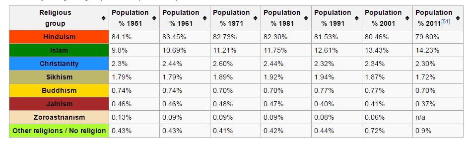
8. Religious demographics
The religious data on India Census 2011 was released by the Government of India on 25 August 2015.
Hindus are 79.8% (966.3 million), while Muslims are 14.23% (172.2 million) in India.
For the first time, a “No religion” category was added in the 2011 census. 2.87 million were classified as people belonging to “No Religion” in India in the 2011 census – 0.24% of India’s total population of 1.21 billion.
Given below is the decade-by-decade religious composition of India till the 2011 census. There are six religions in India that have been awarded “National Minority” status – Muslims, Christians, Sikhs, Jains, Buddhists and Parsis.
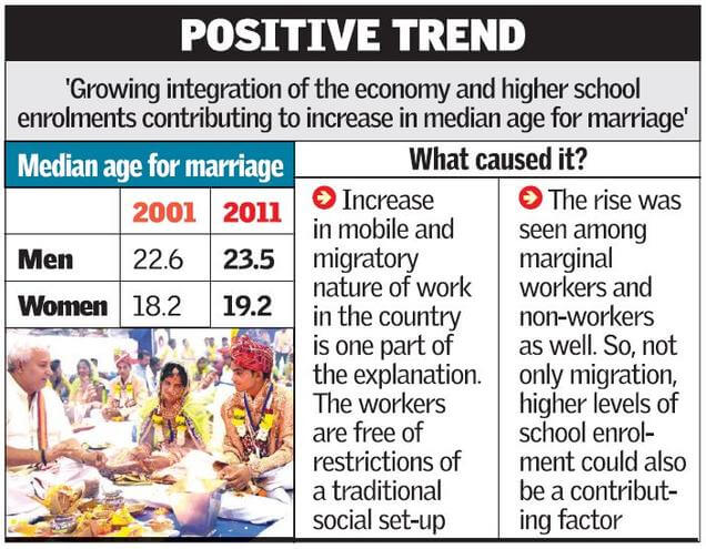
9. Median marriage age
The median age increased for men – from 22.6 (2001) to 23.5 (2011) and for women – from 18.2 (2001) to 19.2 (2011)
SOCIO-ECONOMIC CASTE CENSUS
Introduction
- The Ministry of Rural Development commenced the Socio Economic and Caste Census (SECC) in June 2011 through a comprehensive door to door enumeration across the country. This is the first time such a comprehensive exercise has been carried out for both rural and urban India. It has generated information on a large number of social and economic indicators relating to households across the country.
- SECC 2011 is also first paperless census in India conducted on hand-held electronic devices by the government in 640 districts.
- The rural development ministry has taken a decision to use the SECC data in all its programmers such as MGNREGA, National Food Security Act etc.
- SECC 2011 data will also be used to identify beneficiary and expand the direct benefit transfer scheme as part of its plans to build upon the JAM (Pradhan Mantri Jan Dhan Yojana-AadhaarMobile number portability) trinity.
Why SECC
- The feeling was that the current definition of poverty — which was derived by identifying a basket of essential goods and services and marking the point in India’s income distribution where that basket could be purchased by an individual — was missing too much.
- For one, the numbers seemed absurdly low — set at Rs.816 per person per month in rural areas and Rs. 1,000 in urban areas by the Planning Commission by updating the Tendulkar methodology, the numbers amounted to a daily expenditure of around Rs.30, which caused public indignation. A new committee was formed which drew a new line, but the Rangarajan methodology too wound up at a poverty line not very different from the Tendulkar line.
- So, a broader and more dynamic definition of poverty seemed important.
- Also, while the general census was about individuals, the SECC was based on households and this gives a more accurate picture of the economic status of families.
Objectives
1) To enable households to be ranked based on their Socio- Economic status, so that State Governments can then prepare a list of families living below the poverty line.
2) To make available authentic information that will enable caste-wise population enumeration of the country, and education status of various castes and sections of the population.
It is relevant to note that the regular Population Census is carried out under Census Act, 1948. According to this Act, Government must keep individual’s personal information confidential.
Besides aim of regular Population Census is to provide overview, it is not concerned with any particular individual / household. Thus, personal data given in Population Census is confidential.
On the contrary all the personal information given in the Socio Economic Caste Census (SECC) is open for use by Government departments to grant and/ or restrict benefits to households. This required the right of verification of socio economic profile.
Criteria used in SECC 2011
SECC uses the parameters laid down by the S R Hashim committee appointed by the erstwhile Planning Commission of India i.e., automatic exclusion on the basis of 14 parameters, automatic inclusion on the basis of 5 parameters and grading of deprivation on the basis of seven criteria.
14 parameters of Automatic Exclusion: –
o motorized 2/3/4 wheeler/fishing boat.
o Mechanized 3-4 wheeler agricultural equipment.
o Kisan credit card with credit limit of over Rs. 50,000/-.
o Household member government employee.
o Households with non-agricultural enterprises registered with government.
o Any member of household earning more than Rs. 10,000 per month.
o Paying income tax.
o Paying professional tax.
o 3 or more rooms with pucca walls and roof.
o owns a refrigerator.
o Owns landline phone.
o Owns more than 2.5 acres of irrigated land with 1 irrigation equipment.
o 5 acres or more of irrigated land for two or more crop season.
o Owning at least 7.5 acres of land or more with at least one irrigation equipment.
5 parameters of Automatic inclusion:
o Households without shelter.
o Destitute, living on alms.
o Manual scavenger families.
o Primitive tribal groups.
o Legally released bonded labour.
Households based on 7 markers of deprivation:
o Households with Kutchha house
o No adult member in working age
o Household headed by female and no working age male member
o Household with handicapped members and no able bodied adult
o Household with no literate over 25 years
o Landless households engaged in manual labour
o SC/ST households.
Key Findings
Data addresses multi-dimensionality of poverty, and provides opportunity for a convergent, evidence based planning with Gram Panchayat, as a unit. It is an opportunity for evidence based selection, prioritisation and targeting of beneficiaries in different programs.
Some of the findings of the SECC are as under:
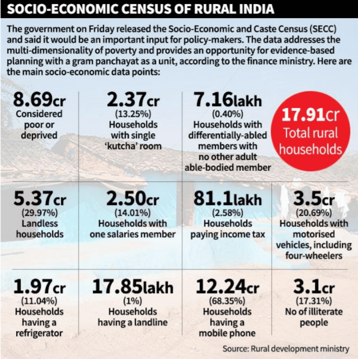
1) There are a total number of 24.39 crore households in India, of which 17.91 crore live in villages. Of these, 10.69 crore households are considered as deprived. The economic status of a household was computed through seven indicators of deprivation covering aspects of landlessness, housing, source of income, disability etc.
2) 49% of the households can be considered poor in the sense of facing some deprivation. These households show signs of poverty even though depth of poverty may be not enough to categorise them as poor. These deprivations range from lack housing facility and education, to absence of any male earning member, to households depending mainly on manual labour etc. This finding points to the need to have a comprehensive social security structure.
3) These extremely low income numbers follow from the nature of employment that most of rural India is engaged in. The vast majority – over 90% – of rural India, does not have salaried jobs.
4) Working in anything other than agriculture will be a tough ask, given the level of education – fewer than 10 per cent make it to higher secondary or above and just 3.41 per cent of households have a family member who is at least a graduate.
5) Only 30% of rural households depend on cultivation as their main source of income. Whereas 51.14% derive sustenance from manual casual labour (MCL). Fragmentation of landholdings has made it difficult for even farmers to support themselves, let alone those dependent on MCL. Therefore, getting people out of farms will spur mechanisation and consolidation of land holdings, leading to increased agricultural productivity in the long run.
6) In nearly 75 per cent of the rural households, the main earning family member makes less than Rs 5,000 per month (or Rs 60,000 annually). In just eight per cent of households does the main earning member makes more than Rs. 10,000 per month.
7) 56.25% of rural households hold no agricultural land. The numbers also point to the subsistence level of farming that rural India currently practices. Therefore, creation of gainful non-farm employment should receive top priority in policy making.