COASTAL PLAINS OF INDIA
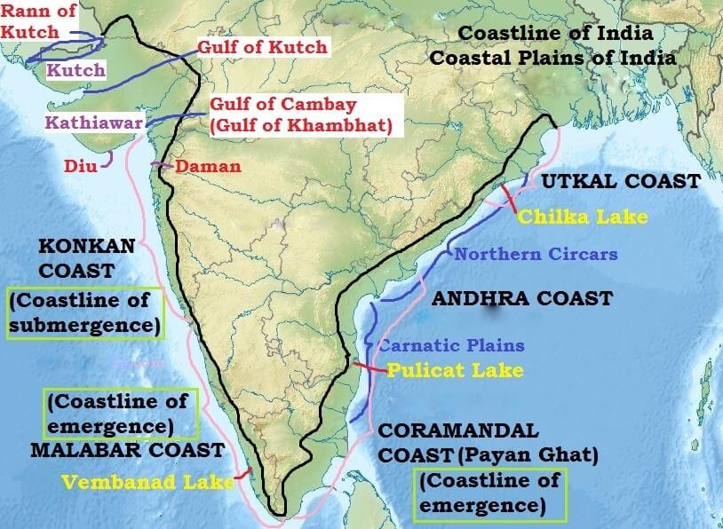
East Coast of India
• Lies between the Eastern Ghats and the Bay of Bengal
• It extends from the Ganga delta to Kanyakumari
• It is marked by deltas of rivers like the Mahanadi, the Godavari, the Krishna and the Cauvery
• Chilka lake and the Pulicat lake (lagoon) are the important geographical features of east coast
Regional Names of the East Coast of India
• In Orissa (Odisha) it is known as Utkal coast
• From the southern limit of the Utkal plain, stretch the Andhra coast
• In the south of the Andhra plain is the Tamil Nadu coast
• The Tamil Nadu coast and parts of Andhra coast together are known as Coramandal Coast or Payan Ghat [False Divi Point in AP (Krishna River Delta) in the north to Kanyakumari in the south]
West Coast of India
• The west coast strip extends from the Gulf of Cambay (Gulf of Khambhat) in the north to Cape Comorin (Kanniyakumari).
• Starting from north to south, it is divided into (i) the Konkan coast, (ii) the Karnataka coast and (iii) the Kerala cost.
• It is made up of alluvium brought down by the short streams originating from the Western Ghats.
• It is dotted with a large number of coves (a very small bay), creeks (a narrow, sheltered waterway such as an inlet in a shoreline or channel in a marsh) and a few estuaries. {Marine Landforms}
• The estuaries, of the Narmada and the Tapi are the major ones.
• The Kerala coast (Malabar Coast) has some lakes, lagoons and backwaters, the largest being the Vembanad Lake.
Regional Names of the West Coast of India
• Konkan coast == Maharashtra coast and Goa coast;
• Malabar Coast == Kerala and Karnataka coast.
Coastlines
• Coastline of emergence is formed either by an uplift of the land or by the lowering of the sea level. Coastline of submergence is an exact opposite case.
• Bars, spits, lagoons, salt marshes, beaches, sea cliffs and arches are the typical features of emergence.
• The east coast of India, especially its south-eastern part (Tamil Nadu coast), appears to be a coast of emergence.
• The west coast of India, on the other hand, is both emergent and submergent.
• The northern portion of the coast is submerged as a result of faulting and the southern portion, that is the Kerala coast, is an example of an emergent coast.
• Coramandal coast (Tamil Nadu) ==> Coastline of emergence
• Malabar coast (Kerala Coast) ==> Coastline of emergence
• Konkan coast (Maharashtra and Goa Coast) ==> Coastline of submergence.
Western Coastal Plains of India
• Rann of Kachchh in the north to Kanniyakumari in the South.
• These are narrow plains with an average width of about 65 km.
Kutch and Kathiawar region
• Kutch and Kathiawar, though an extension of Peninsular plateau (because Kathiawar is made of the Deccan Lava and there are tertiary rocks in the Kutch area), they are still treated as integral part of the Western Coastal Plains as they are now levelled down.
• The Kutch Peninsula was an island surrounded by seas and lagoons. These seas and lagoons were later filled by sediment brought by the Indus River which used to flow through this area. Lack of rains in recent times has turned it into arid and semi-arid landscape.
• Salt-soaked plain to the north of Kutch is the Great Rann. Its southern continuation, known as the Little Rann lies on the coast and south-east of Kachchh.
• The Kathiawar Peninsula lies to the south of the Kachchh. The central part is a highland of Mandav Hills from which small streams radiate in all directions (Radial Drainage). Mt. Girnar (1,117 m) is the highest point and is of volcanic origin.
• The Gir Range is located in the southern part of the Kathiawar peninsula. It is covered with dense forests and is famous as home of the Gir lion.
Gujarat Plain
• The Gujarat Plain lies east of Kachchh and Kathiawar and slopes towards the west and south west.
• Formed by the rivers Narmada, Tapi, Mahi and Sabarmati, the plain includes the southern part of Gujarat and the coastal areas of the Gulf of Khambhat.
• The eastern part of this plain is fertile enough to support agriculture, but the greater part near the coast is covered by windblown loess (heaps of sand).
Konkan Plain
• The Konkan Plain south of the Gujarat plain extends from Daman to Goa (50 to 80 km wide).
• It has some features of marine erosion including cliffs, shoals, reefs and islands in the Arabian Sea.
• The Thane creek around Mumbai is an important embayment (a recess in a coastline forming a bay) which provides an excellent natural harbour.
Karnataka Coastal Plain
• Goa to Mangalore
• It is a narrow plain with an average width of 30-50 km, the maximum being 70 km near Mangalore.
• At some places the streams originating in the Western Ghats descend along steep slopes and make waterfalls.
• The Sharavati while descending over such a steep slope makes an impressive waterfall known as Gersoppa (Jog) Falls which is 271 m high. [Angel falls (979 m) in Venezuela is the highest waterfall on earth. Tugela Falls (948 m) in Drakensberg mountains in South Africa is the second highest.]
• Marine topography is quite marked on the coast.
Kerala Plain
• The Kerala Plain also known as the Malabar Plain.
• Between Mangalore and Kanyakumari.
• This is much wider than the Karnataka plain. It is a low lying plain.
• The existence of lakes, lagoons, backwaters, spits, etc. is a significant characteristic of the Kerala coast.
• The backwaters, locally known as kayals are the shallow lagoons or inlets of the sea, lying parallel to the coastline.
• The largest among these is the Vembanad Lake which is about 75 km long and 5-10 km wide and gives rise to a 55 km long spit {Marine Landforms}.
Eastern Coastal Plains of India
• Extending from the Subarnarekha river along the West Bengal-Odisha border to Kanyakumari.
• A major part of the plains is formed as a result of the alluvial fillings of the littoral zone (relating to or on the shore of the sea or a lake) by the rivers Mahanadi, Godavari, Krishna and Cauvery comprising some of the largest deltas.
• In contrast to the West Coastal Plains, these are extensive plains with an average width of 120 km.
rivers and Carnatic between the Krishna and the Cauvery rivers.
Utkal Plain
• The Utkal Plain comprises coastal areas of Odisha.
• It includes the Mahanadi delta.
• The most prominent physiographic feature of this plain is the Chilka Lake.
• It is the biggest lake in the country and its area varies between 780 sq km in winter to 1,144 sq km in the monsoon months.
• South of Chilka Lake, low hills dot the plain.
Andhra Plain
• of the Utkal Plain and extends upto Pulicat Lake. This lake has been barred by a long sand spit known as Sriharikota Island (ISRO launch facility).
• The most significant feature of this plain is the delta formation by the rivers Godavari and Krishna.
• The two deltas have merged with each other and formed a single physiographic unit.
• The combined delta has advanced by about 35 km towards the sea during the recent years. This is clear from the present location of the Kolleru Lake which was once a lagoon at the shore but now lies far inland {Coastline of Emergence}.
• This part of the plain has a straight coast and badly lacks good harbours with the exception of Vishakhapatnam and Machilipatnam.
Tamil Nadu Plain
• The Tamil Nadu Plain stretches for 675 km from Pulicat lake to Kanniyakumari along the coast of Tamil Nadu. Its average width is 100 km.
• The most important feature of this plain is the Cauvery delta where the plain is 130 km wide.
• The fertile soil and large scale irrigation facilities have made the Cauvery delta the granary of South India.
Significance of the Coastal Plains
• Large parts of the coastal plains of India are covered by fertile soils on which different crops are grown. Rice is the main crop of these areas.
• Coconut trees grow all along the coast.
• The entire length of the coast is dotted with big and small ports which help in carrying out trade.
• The sedimentary rocks of these plains are said to contain large deposits of mineral oil (KG Basin).
• The sands of Kerala coast have large quantity of MONAZITE which is used for nuclear power.
• Fishing is an important occupation of the people living in the coastal areas.
• Low lying areas of Gujarat are famous for producing salt.
• Kerala backwaters are important tourist destinations.
• Goa provides good beaches. This is also an important tourist destination.
ISLAND GROUPS OF INDIA
• The major islands groups of India are Andaman and Nicobar Archipelago (A chain of islands similar in origin) in Bay of Bengal and Lakshadweep islands in Arabian Sea.
• Andaman and Nicobar Islands were formed due to collision between Indian Plate and Burma Minor Plate [part of Eurasian Plate][Similar to formation of Himalayas].
• Andaman and Nicobar Islands are southward extension of Arakan Yoma range [Myanmar][Arakan Yoma in itself is an extension of Purvanchal Hills].
• Lakshadweep Islands are coral islands. These islands are a part Reunion Hotspot volcanism.
• Other than these two groups there are islands in Indo-Gangetic Delta [they are more a part of delta than islands] and between India and Sri Lanka [Remnants of Adams Bridge; formed due to submergence].
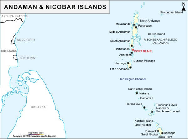
Andaman and Nicobar Islands
• This archipelago is composed of 265 big and small islands [203 Andaman islands + 62 Nicobar Islands]
• The Andaman and Nicobar islands extend from 6° 45′ N to 13° 45′ N and from 92° 10′ E to 94° 15′ E for a distance of about 590 km.
• The Andaman Islands are divided into three main islands i.e. North, Middle and South.
• Duncan passage separates Little Andaman from South Andaman.
• The Great Andaman group of islands in the north is separated by the Ten Degree Channel from the Nicobar group in the south
• Port Blair, the capital of Andaman Nicobar Islands lies in the South Andaman.
• Among the Nicobar Islands, the Great Nicobar is the largest. It is the southernmost island and is very close to Sumatra island of Indonesia. The Car Nicobar is the northernmost.
• Most of these islands are made of tertiary sandstone, limestone and shale resting on basic and ultrabasic volcanoes [Similar to Himalayas].
• Barren Island and Narcondam Island, north of Port Blair, are volcanic islands [these are the only active volcanoes in India][There are no active volcanoes in main land India].
• Some of the islands are fringed with coral reefs. Many of them are covered with thick forests. Most of the islands are mountainous.
• Saddle peak (737 m) in North Andaman is the highest peak.
Lakshadweep Islands
• In the Arabian Sea, there are three groups of islands:
1. Amindivi Islands (consisting of six main islands of Amini, Keltan, Chetlat, Kadmat, Bitra and Perumul Par).
2. Laccadive Islands (consisting of five major islands of Androth, Kalpeni, Kavaratti, Pitti and Suheli Par) and
3. Minicoy Island.
• At present these islands are collectively known as Lakshadweep.
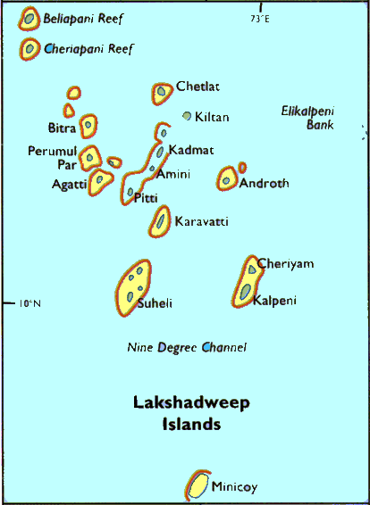
• The Lakshadweep Islands are a group of 25 small islands.
• They are widely scattered about 200-500 km south-west of the Kerala coast.
• Amindvi Islands are the northern most while the Minicoy island is the southernmost.
• All are tiny islands of coral origin {Atoll} and are surrounded by fringing reefs.
• The largest and the most advanced is the Minicoy Island with an area of 4.53 sq km.
• Most of the islands have low elevation and do not rise more than five metre above sea level (Extremely Vulnerable to sea level change).
• Their topography is flat and relief features such as hills, streams, valleys, etc. are absent.
New Moore Island
• It is a small uninhabited offshore sandbar landform in the Bay of Bengal, off the coast of the Ganges-Brahmaputra Delta region.
• It emerged in the Bay of Bengal in the aftermath of the Bhola cyclone in 1970. It keeps on emerging and disappearing.
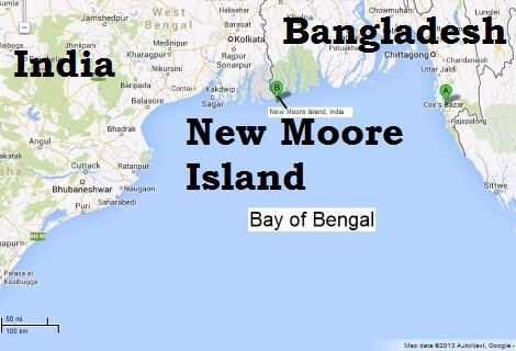
• Although the island was uninhabited and there were no permanent settlements or stations located on it, both India and Bangladesh claimed sovereignty over it because of speculation over the existence of oil and natural gas in the region.
• The issue of sovereignty was also a part of the larger dispute over the Radcliffe Award methodology of settling the maritime boundary between the two nations.
CLIMATE OF INDIA
• India’s climate closely resembles the climate that of a tropical country although its northern part (north of tropic of cancer) is situated in the temperate belt.
• Indian subcontinent is separated from the rest of Asia by the lofty Himalayan ranges which block the cold air masses moving southwards from Central Asia.
• As a result, during winters, the northern half of India is warmer by 3°C to 8°C than other areas located on same latitudes.
• During summer, due to over the head position of the sun, the climate in the southern parts resemble equatorial dry climate.
• The north Indian plains are under the influence of hot dry wind called ‘loo’ blowing the Thar, Baloch and Iranian Deserts, increasing the temperatures to a level comparable to that of the southern parts of the country.
• Thus the whole of India, south of the Himalayas can be climatically treated as a tropical country.
• The seasonal reversal of winds in Arabian Sea and Bay of Bengal give India a typical tropical monsoon climate.
• So Indian climate, to be precise, is tropical monsoon type (a distinct wet and dry climate) rather than just a tropical or half temperate climate.
Features of Indian Climate
• India has high Regional Climatic Diversity because of its topographical diversity (location, altitude, distance from sea and relief).
Rainfall
• The climate in most of the regions is characterized by distinct wet and dry seasons. Some places like Thar desert, Ladakh have no wet season.
• Mean annual rainfall varies substantially from region to region. Mawsynram and Cherrapunji in Meghalaya receive around 1,000 cm of annual rainfall while at Jaisalmer the annual rainfall rarely exceeds 12 cm.
• The Ganga delta and the coastal plains of Odisha see intense rainfall in July and August while the Coromandel Coast goes dry during these months.
• Places like Goa, Hyderabad and Patna receive south-west monsoon rains by the first quarter of June while the rains are awaited till early July at places in Northwest India
Temperature
• Diurnal and annual temperature ranges are substantial
• Highest diurnal temperature ranges occur in the Thar desert and the highest annual temperature ranges are recorded in the Himalayan regions
• Both diurnal and mean annual temperature ranges are least in coastal regions
• In December, the temperature may dip to – 40°C at some places in J&K while in many coastal regions average temperature is 20-25°C
• Winters are moderately cold in most of the regions while the summers are extremely hot
• Himalayan regions experience brutal winters while the summers are moderate
Factors Influencing Indian Climate
- Latitudinal location
- Distance from the Sea
- The Himalayas
- Physiography
- Monsoon Winds
- Upper Air Circulation
- El Nino and La Nina
- Tropical Cyclones and Western Disturbances
- Latitudinal location
• Indian climate resembles the climate of a tropical country.
• The mainland of India extends between 8°N to 37°N.
• Areas south of the Tropic of Cancer are in tropics and hence receive high solar insolation. The summer temperatures are extreme and winters temperatures are moderate in most of the regions.
• The northern parts on the other hand lie in the warm temperate zone. They receive comparatively less solar insolation. But summers are equally hot in north India because of hot local wind called ‘loo’. Winters are very cold due to cold waves brought by the western disturbances.
• Some places in Himalayas record very low temperatures in winter.
• Coastal regions see moderate climatic conditions irrespective of latitudinal position.
- Distance from the Sea
• Coastal regions have moderate or equable or maritime climate where as interior locations are deprived of the moderating influence of the sea and experience extreme or continental climate.
• The monsoon winds first reach the coastal regions and hence bring good amount of rainfall.
- Himalayas and Indian Climate
• This is the most important factor that influences Indian Climate.
• The Himalayas act as a climatic divide between India and Central Asia.
• During winter, Himalayas protect India from cold and dry air masses of Central Asia.
• During monsoon months these mountain ranges act as an effective physical barrier for rain bearing south-west monsoon winds.
• Himalayas divide the Bay of Bengal branch of monsoon winds into two branches – one branch flowing along the plain regions towards north-west India and the other towards South-East Asia.
• If the Himalayas were not present, the monsoon winds would simply move into China and most of the north India would have been a desert.
Why does rainfall decrease form east to west in the Indo-Gangetic Plains?
• In summer, there are many minor low pressure cells that exist all over the plain region.
• As the monsoon winds move from east to west the moisture levels decrease due to successive rainfall at each low pressure regions.
• By the time winds reach western parts of the plains (Delhi, Haryana etc.) all the moisture in the monsoon winds in exhausted.
- Physiography and Indian Climate
• Physiography is the most important factor that determines the mean annual rainfall received by a region.
Why are some parts in peninsular India semi-arid?
• Places on the windward side of an orographic barrier receive great amount of rainfall where as those on the leeward side remain arid to semi-arid due to rain-shadow effect.
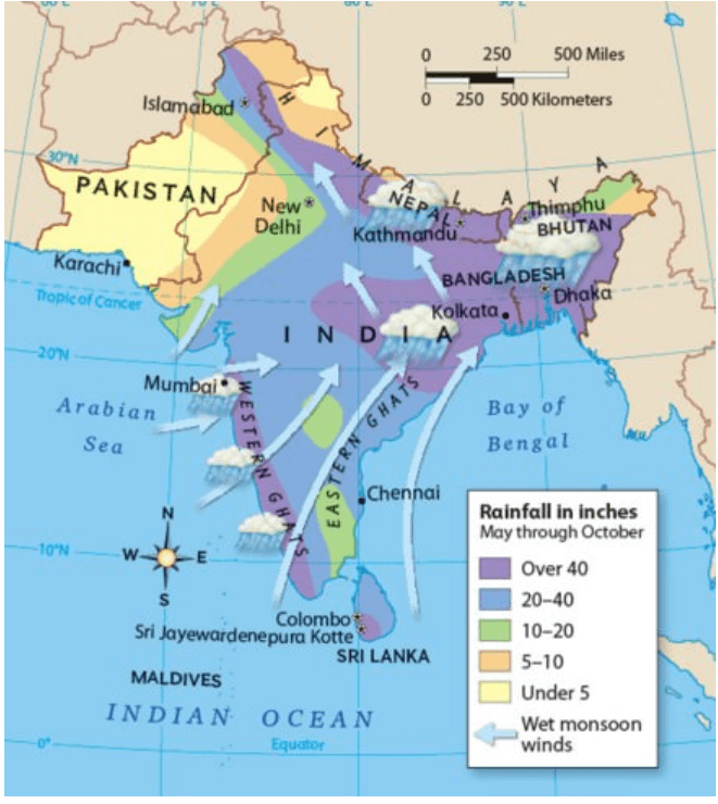
• Example: The south-west monsoon winds from the Arabian sea strike almost perpendicular at the Western Ghats and cause copious rainfall in the Western Coastal plain and the western slopes of the Western Ghats.
• On the contrary, vast areas of Maharashtra, Karnataka, Telangana, Andhra Pradesh and Tamil Nadu lie in rain-shadow or leeward side of the Western Ghats and receive scanty rainfall.
Why is there no significant rainfall in Gujarat and Rajasthan? Explain the formation of Thar Desert.
• Monsoons winds flowing in Rajasthan and Gujarat are not obstructed by any orographic barrier and hence these regions receive no rainfall.
- Monsoon winds blow almost parallel to Aravalis and hence there is no orographic rainfall
- No convection cell or vertical wind movements arise in Rajasthan and Gujarat: Monsoon winds blow towards low pressure cells in Tibet and hence only horizontal wind movements exist in Gujarat and Rajasthan
- Sub-tropical high pressure belt: In winter the region experiences strong divergence because of the STJ – Sub-Tropical Jet.
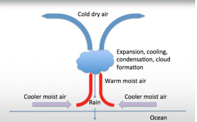
Why do Cherrapunji and Mawsynram receive abnormally high rainfall?
• Mawsynram and Cherrapunji (Meghalaya) are the wettest places on earth with mean annual rainfall over 1000 cm.
• Copious rainfall in these places is due to funnelling effect followed by orographic upliftment.
• Cherrapunji receives rains from the Bay of Bengal arm of the Indian summer monsoon. The monsoon clouds fly unhindered over the plains of Bangladesh for about 400 km. Thereafter, they hit the Khasi Hills which rise abruptly from the plains to a height of about 1,370 m above mean sea level within 2 to 5 km. The geography of the hills with many deep valley channels encompassing the low-flying (150–300 m) moisture-laden clouds from a wide area converges over Cherrapunji.
• The winds push the rain clouds through these gorges and up the steep slopes. The rapid ascent of the clouds into the upper atmosphere hastens the cooling and helps vapours to condense. Most of the rain is the result of air being lifted as a large body of water vapour. The extreme amount of rainfall is perhaps the best-known feature of orographic rain in northeastern India.
• [Funneling effect = clouds are channeled into a narrow region between mountains and hence the cloud density is extraordinary]
- Monsoon Winds and Indian Climate
• The most dominating factor of the Indian climate is the ‘monsoon winds’.
Important features of Indian Monsoons are
- Sudden onset (sudden burst)
- Gradual progress
- Gradual retreat
- Seasonal reversal of winds
• The complete reversal of the monsoon winds brings about a sudden change in the seasons.
• The harsh summer season suddenly giving way to monsoon or rainy season
• The south-west monsoons from the Arabian Sea and the Bay of Bengal bring rainfall to the entire country.
• The north-eastern winter monsoon does not cause much rainfall except along the Coramandal coast (TN coast) after getting moisture from the Bay of Bengal.
- Upper Air Circulation
• The changes in the upper air circulation over Indian landmass is brought about by Jet streams.
Westerly Jet Stream
• Westerly jet stream blows at a very high speed during winter over the sub-tropical zone.
• Southern branch of the jet stream exercises a significant influence on the winter weather conditions in India.
• This jet stream is responsible for bringing western disturbances from the Mediterranean region in to the Indian sub-continent.
• Winter rain and heat storms in north-western plains and occasional heavy snowfall in hilly regions are caused by these disturbances.
• These are generally followed by cold waves in the whole of northern plains.
Easterly Jet Stream
• Reversal in upper air circulation takes place in summer due to the apparent shift of the sun’s vertical rays in the northern hemisphere.
• The westerly jet stream is replaced by the easterly jet stream which owes its origin to the heating of the Tibet plateau.
• This helps in the sudden onset of the south-west monsoons.
- El-Nino, La Nina, ENSO and Indian Climate
El Nino
• Adversely affects monsoon rainfall and cyclogenesis (cyclone formation) in Bay of Bengal.
• Encourages cyclogenesis in the Arabian Sea.
• Droughts are common during El Nino events due to less monsoonal and cyclonic rainfall.
La Nina
• Good for monsoons and cyclogenesis in the Bay of Bengal
• Suppresses cyclogenesis in Arabian Sea
• Floods are common.
ENSO
• Southern Oscillation is simply the oscillation or alternating positions of low pressure and high pressure cells over eastern and western Pacific.
• Southern Oscillation coinciding with El Nino is called ENSO or El Nino Southern Oscillation. (SO usually coincides with El Nino. This why El Nino is usually referred to as ENSO)
• ENSO = [warm water in eastern Pacific + low pressure over eastern Pacific] + [cool water in western Pacific + high pressure in western Pacific]
• Climatic conditions are the same as El Nino
- Tropical Cyclones and Western Disturbances
• Tropical cyclones originate in the Bay of Bengal and Arabian Sea and the influence large parts of the peninsular India.
• Majority of the cyclones originate in the Bay of Bengal and influence the weather conditions during the south-west monsoon season (low intensity cyclones).
• Some cyclones are born during the retreating monsoon season, i.e., in October and November (high intensity cyclones) and influence the weather conditions along the eastern coast of India.
• The western disturbances originate over the Mediterranean Sea and travel eastward under the influence of westerly jet stream.
• They influence the winter weather conditions over most of Northern-plains and Western Himalayan region.
SUMMER SEASON IN INDIA
• March to June
• High temperature and low humidity are the chief characteristics
• Sometimes referred to as pre-monsoon period
Temperature in Summer Season
• High solar insolation due to apparent movement of sun between the equator and the Tropic of Cancer
• The southern parts of the country are distinctly warmer in March and April whereas in June, north India has higher temperatures.
• In March, the highest temperatures occur in the southern parts (40-45°C).
• In April the highest temperature of about 45°C is recorded in the northern parts of Madhya Pradesh.
• In May the highest temperature shifts to Rajasthan where temperatures as high as 48°C may be recorded.
• In June the maximum temperature is in Punjab and Haryana.
• The highest temperatures are recorded just before the onset of the southwest monsoons (late May).
• The diurnal range of temperature is also very high. It may be as high as 18°C in some parts.
• The maximum summer temperatures are comparatively lower in the costal and southern peninsular regions due to moderating effect of the sea.
• The temperatures along the west coast are comparatively lower than those prevailing on the east coast due to the prevailing westerly winds.
• There is large contrast between land and sea temperatures.
• Northern and central parts of India experience heat waves in this season.
• Most of the heat waves develop over Rajasthan, Punjab and Haryana (location far away from the sea). From here they spread over Delhi, Uttar Pradesh and Bihar.
• The strong north westerly winds (caused due to strong divergence in north-west India) with a long land journey over hot regions check the onward march of the sea breeze over eastern coastal belt and create heat wave conditions over Odisha and Andhra Pradesh.
• The heat waves strike by the end of April and their maximum occurrence is in May. They last till the onset of southwest monsoon.
• The normal duration of heat waves is 4 to 5 days. However, heat waves are rare over the peninsula south of 13°N latitude due to maritime conditions prevailing there.
Pressure in Summer Season
• The atmospheric pressure is low all over the country due to high temperature.
• But strong dynamically induced divergence over north-west India prevents the onset of south-west monsoons.
Winds in Summer Season
• There is a marked change in the direction and speed of the winds from winter.
• The winds are by and large light and variable.
Loo
• Loo winds originate over Iranian, Baloch and Thar deserts.
• In May and June, high temperature in northwest India builds steep pressure gradient.
• Hot, dust laden and strong wind known as loo blows.
• Loo normally starts blowing by 9.00 A.M., increases gradually and reaches maximum intensity in the afternoon.
• It blows with an average speed of 30-40 km per hour and persists for days.
Andhis
• The strong dust storms resulting from the convective phenomena are locally known as andhis (blinding storms). They move like a solid wall of dust and sand.
• The wind velocity often reaches 50-60 kmph and the visibility is reduced to a few metres.
• Such dust storms are common in Rajasthan, Haryana, Punjab, Jammu region, Delhi, Uttar Pradesh, Bihar and Madhya Pradesh.
• They are short lived. The squall and showers which follow these storms bring down the temperature sharply temporarily.
Frontal Thunderstorms in Summer Season
• The strong convectional movements related to the westerly jet stream lead to thunderstorms in eastern and north-eastern part of the country.
• They normally originate over Chota Nagpur plateau and are carried eastwards by westerly winds.
• The areas with highest incidence of thunderstorms are Assam, Arunachal Pradesh, Nagaland, Mizoram, Manipur, Tripura, Meghalaya, West Bengal and the adjoining areas of Odisha and Jharkhand.
Norwesters and Thunderstorms in Summer Season
• In West Bengal and the adjoining areas of Jharkhand, Odisha and Assam, the direction of squalls is mainly from the northwest, and they are called norwesters.
• They are often very violent with squall speeds of 60 to 80 km per hour.
• Hailstones sometimes accompany showers and occasionally attain the size of a golf ball.
• They cause heavy damage to standing crops, trees, buildings, livestock and even lead to loss of human lives.
• However, they are, sometimes, useful for tea, jute and rice cultivation. In Assam, these storms are known as ‘Barodoli Chheerha’.
• The period of maximum occurrence of these storms is the month of Vaisakh (mid-March to mid-April) and hence, they are locally known as Kalabaisakhis, the black storms or a mass of dark clouds of Vaiasakha.
Convectional Thunderstorms in Summer Season
• In the south the thunderstorms occur in Kerala (Mango Showers) and adjoining parts of Karnataka (Blossom Showers) and Tamil Nadu, particularly during evenings and nights.
Tropical Cyclones in Summer Season
• Tropical cyclones originate in the Bay of Bengal and Arabian Sea.
• A few cyclones are formed in the Bay of Bengal in the month of March but they do not affect the mainland of India.
• Their frequency rises steeply in April and the number of cyclones originating in May is more than double than those originating in April.
• About three-fourths of the tropical cyclones are born in the Bay of Bengal and the rest originate in the Arabian Sea.
• Most of the depressions in April originate to the south of 10°N while those originating in May are born to the north of this latitude.
• Most of the storms of this season initially move west or north-west but later they recurve northeast and strike Bangladesh and the Arakan Coast of Myanmar.
• Very few hit Indian coast while some dissipate over the sea itself.
• The whole of the east coast of India, the coastal areas of Bangladesh and Arakan Coast of Myanmar are liable to be hit by tropical storms in May.
• Many of them are quite severe and cause heavy damage to life and property.
• In the Arabian Sea, major storms are formed in May between 7° and 12° N latitudes.
• Most of them move away from the Indian coast in a north-westerly direction and dissipate in the sea.
• Few originate close to the Indian coast. They move towards the north-east and hit somewhere along the west coast of India.
Precipitation in Summer Season
• This season is not totally rainless (only one per cent of the annual rainfall).
• In the northeastern parts of the country, dust storms bring little rainfall.
• The precipitation in Kashmir is mainly in the form of snow caused by western disturbances.
• The norwesters bring some rainfall in Assam, West Bengal and Odisha. The intensity of rainfall is high.
• The rainfall brought by the norwesters is known as the spring storm showers.
• This small amount of rainfall is very useful for the cultivation of tea, jute and rice and is known as tea showers in Assam.
• Coastal areas of Kerala and Karnataka receive rainfall from thunderstorms.
• Such showers are called mango showers in Tamil Nadu and Andhra Pradesh because they are very beneficial to mango crop.
• In Karnataka they are called cherry blossoms due to their positive effect on coffee plantations.
INDIAN MONSOONS
• The term monsoon has been derived from the Arabic word mausim or from the Malayan word monsin meaning season.
• Monsoons are seasonal winds (Rhythmic wind movements)(Periodic Winds) which reverse their direction with the change of season.
• The monsoon is a double system of seasonal winds – They flow from sea to land during the summer and from land to sea during winter.
• Some scholars tend to treat the monsoon winds as land and sea breeze on a large scale.
• Monsoons are peculiar to Indian subcontinent, South East Asia, parts of Central Western Africa etc.
• They are more pronounced in the Indian subcontinent compared to any other region.
• Indian Monsoons are Convection cells on a very large scale.
• They are periodic or secondary winds which seasonal reversal in wind direction.
• India receives south-west monsoon winds in summer and north-east monsoon winds in winter.
• South-west monsoons are formed due to intense low pressure system formed over the Tibetan plateau.
• North-east monsoons are associated with high pressure cells over Tibetan and Siberian plateaus.
• South-west monsoons bring intense rainfall to most of the regions in India and north-east monsoons bring rainfall to mainly south-eastern coast of India (Southern coast of Seemandhra and the coast of Tamil Nadu.).
• Countries like India, Indonesia, Bangladesh, Myanmar etc. receive most of the annual rainfall during south-west monsoon season where as South East China, Japan etc., during north-east rainfall season.
Factors responsible for south-west monsoon formation
• Intense heating of Tibetan plateau during summer months
• Permanent high pressure cell in the South Indian Ocean (east to north-east of Madagascar in summer)
Factors that influence the onset of south-west monsoons
- Subtropical Jet Stream (STJ)
- Tropical Easterly Jet (African Easterly Jet)
- Inter Tropical Convergence Zone
Factors that influence the intensity of south-west monsoons
- Strengths of Low pressure over Tibet and high pressure over southern Indian Ocean
- Somali Jet (Findlater Jet)
- Somali Current (Findlater Current)
- Indian Ocean branch of Walker Cell
- Indian Ocean Dipole
Factors responsible for north-east monsoon formation
- Formation and strengthening of high pressure cells over Tibetan plateau and Siberian Plateau in winter
- Westward migration and subsequent weakening of high pressure cell in the Southern Indian Ocean
- Migration of ITCZ to the south of India
Mechanism of Indian Monsoons
• The origin of monsoons is not fully understood. There are several theories that tried to explain the mechanism of monsoons.
Classical Theory
• Monsoons are mentioned in scriptures like the Rig Veda. But these scriptures didn’t make any mention of the monsoon mechanism.
• The first scientific study of the monsoon winds was done by Arab traders.
• Arab traders used the sea route to carry out trade with India and monsoon patterns were of prime importance for them.
• In the tenth century, Al Masudi, an Arab explorer, gave an account of the reversal of ocean currents and the monsoon winds over the north Indian Ocean.
• In seventeenth century, Sir Edmund Halley explained the monsoon as resulting from thermal contrasts between continents and oceans due to their differential heating.
Modern Theories
• Besides differential heating, the development of monsoon is influenced by the shape of the continents, orography (mountains), and the conditions of air circulation in the upper troposphere {jet streams}.
• Therefore, Halley’s theory has lost much of its significance and modern theories based on air masses and jet stream are becoming more relevant.
Sir Edmund Halley’s Theory
• In summer the sun’s apparent path is vertically over the Tropic of Cancer resulting in high temperature and low pressure in Central Asia.
• The pressure is sufficiently high over Arabian Sea and Bay of Bengal. Hence winds flowed from Oceans flow towards landmass in summer.
• This air flow from sea to land brings heavy rainfall to the Indian subcontinent.
• In winter the sun’s apparent path is vertically over the Tropic of Capricorn.
• The north western part of India grows colder than Arabian Sea and Bay of Bengal and the flow of the monsoon is reversed.
• The basic idea behind Classical theory is similar to land and sea breeze formation except that in the case of monsoons the day and night are replaced by summer and winter.
• Drawbacks: The monsoons do not develop equally everywhere on earth and the thermal concept of Halley fails to explain the intricacies of the monsoons such as the sudden burst of monsoons, delay in on set of monsoons sometimes, etc..
Air Mass Theory
• According to this theory, the monsoon is simply a modification of the planetary winds of the tropics.
• The theory is based on the migration of ITCZ based on seasons.
- Indian Monsoons – Role of ITCZ [Inter-Tropical Convergence Zone]
• The southeast trade winds in the southern hemisphere and the northeast trade winds in the northern hemisphere meet each other near the equator.
• The meeting place of these winds is known as the Inter-Tropical Convergence Zone (ITCZ).

• This is the region of ascending air, maximum clouds and heavy rainfall.
• The location of ITCZ shifts north and south of equator with the change of season.
• In the summer season, the sun shines vertically over the Tropic of Cancer and the ITCZ shifts northwards.
• The southeast trade winds of the southern hemisphere cross the equator and start blowing in southwest to northeast direction under the influence of Coriolis force.
• These displaced trade winds are called south-west monsoons when they blow over the Indian sub-continent.
• The front where the south-west monsoons meet the north-east trade winds is known as the Monsoon Front (ITCZ). Rainfall occurs along this front.
• In the month of July the ITCZ shifts to 20°- 25° N latitude and is located in the Indo-Gangetic Plain and the south-west monsoons blow from the Arabian Sea and the Bay of Bengal. The ITCZ in this position is often called the Monsoon Trough [maximum rainfall].
• The seasonal shift of the ITCZ has given the concept of Northern Inter-Tropical Convergence Zone (NITCZ) in summer (July – rainy season) and Southern Inter-Tropical Convergence Zone (SITCZ) in winter (Jan – dry season).
• NITCZ is the zone of clouds and heavy rainfall that affects India.
Jet Stream Theory
• Jet stream Theory is the latest theory regarding the origin of the monsoons and has earned worldwide acceptance from the meteorologists.
How Jet Streams Affect Weather?
• Jet streams have distinct peaks (ridges) and troughs.
• Ridges occur where the warm air mass pushes against the cold air mass. Troughs occur where cold air mass drops into warm air.
• The region on earth below the trough is at low pressure and the region below ridge is at high pressure.
• This condition occurs due to weakening of jet stream due to lesser temperature contrast between sub-tropics and temperate region.
• Usually the trough region [the region exactly below the jet stream trough] creates cyclonic condition (low pressure) at the surface of earth whereas the ridge regions creates anti-cyclonic condition.
• Troughs create upper level divergence which is associated with convergence at the surface (low pressure – cyclonic conditions) and ridges create upper level convergence which is associated with divergence at the surface (high pressure – cyclonic conditions).
• These ridges and troughs give rise to jet streaks which are also responsible for cyclonic and anticyclonic weather conditions at the surface.
• The winds leaving the jet streak are rapidly diverging, creating a lower pressure at the upper level (Tropopause) in the atmosphere. The air below rapidly replaces the upper outflowing winds. This in turn creates the low pressure at the surface. This surface low pressure creates conditions where the surrounding surface winds rush inwards. The Coriolis effect creates the cyclonic rotation (cyclonic vortex) that is associated with depressions [low pressure cells].
• The winds entering the jet streak are rapidly converging because of the high pressure at the upper level (Tropopause) in the atmosphere. This convergence at upper troposphere leads to divergence (high pressure) at the surface (anticyclonic condition).
• The Coriolis effect creates the anticyclonic rotation that is associated with clear weather.
Indian Monsoon Mechanism – Role of Sub-Tropical Jet Stream (STJ)
• Sub-Tropical Jet stream plays a significant role in both hindering the monsoon winds as well as in quick onset of monsoons.
- STJ – Sub-Tropical Jet Stream
• Sub-Tropical Jet stream is a narrow band of fast moving air flowing from west to east [Westerlies].
• STJ in northern hemisphere flows between 25° to 35° N in the upper troposphere at a height of about 12-14 km (all this already discussed in previous posts on Jet Streams). (Here we will consider STJ only. Polar Jet has no influence on Indian monsoons).
• The wind speeds in a westerly jet stream are commonly 150 to 300 km p.h. with extreme values reaching 400 km p.h.
• The burst of monsoons depends upon the upper air circulation which is dominated by STJ.
- Seasonal Migration of Sub-Tropical Jet Stream – STJ
• In winter STJ flows along the southern slopes of the Himalayas but in summer it shifts northwards, rather dramatically, and flows along the northern edge of Himalayas in early June and in late summer (July-August) along the northern edge of the Tibetan Plateau.
• The periodic movement of the Jet stream is often the indicator of the onset (STJ shits to the north of Himalayas in a matter of days) and subsequent withdrawal (STJ returns back to its position – south of Himalayas) of the monsoon.
• Northward movement of the subtropical jet is the first indication of the onset of the monsoon over India.
- Sub-Tropical Jet Stream – STJ in Winter
• Westerly jet stream blows at a very high speed during winter over the sub-tropical zone.
• This jet stream is bifurcated by the Himalayan ranges and Tibetan Plateau.
• The two branches reunite off the east coast of China.
• The northern branch of this jet stream blows along the northern edge of the Tibetan Plateau.
• The southern branch blows to the south of the Himalayan ranges along 25° north latitude.
• A strong latitudinal thermal gradient (differences in temperature), along with other factors, is responsible for the development of southerly jet.
3.1 Western Disturbances
• Meteorologists believe that southern branch of jet stream exercises a significant influence on the winter weather conditions in India.
• The upper jet is responsible for steering of the western depressions [Western Disturbances] from the Mediterranean Sea.
• Some of the depressions continue eastwards, redeveloping in the zone of jet stream confluence about 30° N, 105° E (near east coast of China).
• Winter rain and heat storms in north-western plains and occasional heavy snowfall in hilly regions are caused by these disturbances.
• These are generally followed by cold waves in the whole of northern plains.
• The southern branch is stronger, with an average speed of about 240 km compared with 70 to 90 km p.h. of the northern branch.
• Air subsiding beneath this upper westerly current gives dry out blowing northerly winds from the subtropical anticyclone over north-western India and Pakistan.
- Why no south-west monsoons during winter?
• Reason 1: ITCZ has left India (the winds that blow over India are mostly offshore –– land to land or land to ocean –– so they carry no moisture)
• Reason 2: During winter, the southern branch of STJ is strong and is to the south of Himalayas. The ridge of the jet lies over north-western India and is associated with strong divergence of winds and creates a high pressure region (sub-tropical high pressure belt) over entire north India. [This is how the mechanism of jet streams influence Indian Monsoons in winter season]
• Reason 3: There is already a strong high pressure over Tibet. [High Pressure due to STJ + High Pressure over Tibet = strong divergence = no rainfall]
- Sub-Tropical Jet Stream – STJ in Summer
• With the beginning of summer in the month of March, the STJ [upper westerlies] start their northward march.
• The southerly branch of STJ remains positioned south of Tibet, although weakening in intensity.
• The weather over northern India becomes hot, dry and squally due to larger incoming solar radiation and hot winds like loo.
• Over India, the Equatorial Trough (ITCZ) pushes northwards with the weakening of the STJ [upper westerlies] south of Tibet, but the burst of the monsoon does not take place until the upper-air circulation has switched to its summer pattern.
• By the end of May the southern jet breaks and later it is diverted to the north of Tibet Plateau and there is sudden burst of monsoons (the ridge moves northwards into Central Asia = high pressure over north-west India moves northwards into Central Asia = makes way for south-west monsoon winds). An Easterly jet emerges over peninsular India with the northward migration of STJ.
• The upper air circulations are reversed with the emergence of Easterly jet [convergence in upper layers is replaced by divergence == divergence in lower layers is replaced with convergence == high pressure at lower layers is replaced by low pressure system]. The easterly winds become very active in the upper troposphere and they are associated with westerly winds in the lower troposphere (south-west monsoon winds).
• Western and eastern jets flow to the north and south of the Himalayas respectively. The eastern jet becomes powerful and is stationed at 15° N latitude.
• This results in more active south-west monsoon and heavy rainfall is caused.
- Why no south-west monsoons in March – May (summer)?
• There is good sun’s insolation from March – May but still there is no SW monsoon
• Reason: The ridge region of Southern branch of STJ creates strong divergence (high pressure) in north-west India. The diverging air blocks incoming winds and prevents strong convergence of winds along ITCZ.
• During the summer season in the Northern Hemisphere, low pressure areas develop at the ground surface near Peshawar (Pakistan) and north-west India due to intense heating of ground surface during April, May, and June.
• As long as the position of the upper air jet stream is maintained above the surface low pressure (to the south of Himalayas), the dynamic anti-cyclonic conditions persist over north-west India.
• The winds descending from the upper air high pressure [because of the ridge of STJ] obstructs the ascent of winds from the surface low pressure areas, with the result that the weather remains warm and dry.
• This is why the months of April and May are generally dry and rainless in spite of high temperatures (low pressure on land) and high evaporation.
SOUTH-WEST MONSOON SEASON IN INDIA
ISOLINE: imaginary lines joining regions with equal rainfall or any other parameter.
ISOBAR: imaginary lines joining regions with equal pressure.
ISOTHERM: imaginary lines joining regions with equal temperature.
ISOHYET: imaginary lines joining regions with equal rainfall.
South West Monsoon Season – June to mid-September.
• South West Monsoon Season is also known as hot-wet season
• Sudden onset is the important feature of South West Monsoons
• With the onset of monsoons, temperature falls drastically and humidity levels rise.
Temperature during South West Monsoon Season
• Sudden onset of South West Monsoons leads to significant fall in temperature [3° to 6°C].
• The temperature remains less uniform throughout the rainy season.
• The temperature rises in September with the cease of south-west monsoons.
• There is rise in temperature whenever there is break in the monsoons.
• The diurnal range of temperature is small due to clouds and rains.
• The highest temperatures are experienced at places west of the Aravali [38° to 40°C]. This is due to lack of clouds and hot continental air masses.
• Other parts of Northwest India also have temperatures above 30°C.
• The temperatures are quite low over the Western Ghats due to heavy rainfall.
• The coastal areas of Tamil Nadu and adjoining parts of Andhra Pradesh have temperatures above 30°C as they receive little rainfall during this season.
Pressure and Winds During South West Monsoon Season
• Low pressure conditions prevail over northwest India due to high temperature.
• ITCZ (monsoon trough) lies along the Ganga plain. There are frequent changes in its location depending upon the weather conditions.
• The atmospheric pressure increases steadily southwards.
• Over the peninsular region, due to pressure gradient between north and south, winds blow in a southwest to northeast direction from Arabian Sea and Bay of Bengal.
• Their direction undergoes a change in Indo-Gangetic plain where they move from east to west.
Rainfall During South West Monsoon Season
• Three fourths of the total annual rainfall is received during this season.
• The average rainfall over the plains of India in this season is about 87 per cent.
• Normal date of the arrival of the monsoon is 20th May in Andaman and Nicobar Islands.
• The advance of the monsoon is much faster in the Bay of Bengal than in the Arabian Sea.
• The normal date of onset of the southwest monsoon over Kerala i.e. the first place of entry in the mainland of India is 1st June.
• The monsoons advance quickly accompanied with a lot of thunder, lightning and heavy downpour. This sudden onset of rain is termed as monsoon burst.
• Sometimes monsoons are delayed or they come much earlier than normal.
• Normally the onset occurs between 29th May and 7th June.
• The earliest onset was on 11th May in 1918 and 1955, while the most delayed onset was on 18th June in 1972.
South West Monsoons – Arabian Sea branch and Bay of Bengal branch
• Monsoon winds beyond south Kerala progress in the form of two branches viz. the Arabian Sea branch and the Bay of Bengal branch.
• The Arabian Sea branch gradually advances northwards. It reaches Mumbai by 10th June.
• The Bay of Bengal branch spreads rather rapidly over most of Assam. The normal date of its arrival at Kolkata is 7th June.
• On reaching the foothills of the Himalayas the Bay branch is deflected westward by the Himalayan barrier and it advances up the Gangetic plain.
• The two branches merge with each other mostly around Delhi to form a single current.
• Both the branches reach Delhi more or less at the same time.
• The combined current gradually extends to west Uttar Pradesh, Haryana, Punjab, Rajasthan and finally to Himachal Pradesh and Kashmir.
• By the end of June the monsoon is usually established over most parts of the country.
• By mid-July, the monsoon extends into Kashmir and the remaining parts of the country.
• By this time it reaches Kashmir, it has shed most of its moisture.
• Arabian Sea branch of the monsoon is much powerful than the Bay of Bengal branch for reasons:
- The Arabian Sea is larger than the Bay of Bengal, and
- the entire Arabian Sea current advances towards India, whereas only a part of the Bay of Bengal current enters India, the remainder proceeding to Myanmar, Thailand and Malaysia.
• The Arabian Sea branch of the southwest monsoons is divided into three distinct streams on arriving in the mainland of India.
• The first stream strikes the west coast of India and gives extremely heavy rainfall of over 250 cm. It strikes perpendicular to Western Ghats causing plentiful Orographic Rainfall [400 to 500 cm annual rainfall on the windward side].
• Rainfall is drastically reduced to about 30-50 cm on the leeward side of the crest.
• There is a narrow belt of marked aridity on the immediate leeward side of the Western Ghats. But once it is passed, the air starts rising again and the amount of rainfall increases further east.
• The second stream enters Narmada—Tapi troughs (narrow rift valley) and reaches central India. It does not cause much rain near the coast due to the absence of major orographic obstacle across the rift. Some parts of central India receive rainfall from this stream (Ex: Nagpur).
• The third stream moves parallel to the Aravali Range without causing much rainfall. Consequently the whole of Rajasthan is a desert area.
• However, some orographic effect is occurs on the south-eastern edge of the Aravali Range. Mt. Abu gets about 170 cm rainfall while the surrounding plains have only 60 to 80 cm rainfall.
• The Bay of Bengal Branch of the southwest monsoon is divided into two distinct streams.
• The first stream crosses the Ganga-Brahmaputra delta and reaches Meghalaya. Here that the orographic effect results in intense rainfall. Cherrapunji receives an annual rainfall of 1,102 cm, major portion of which occurs from June to August.
• Mawsynram located at 1,329 m above sea level just 16 km to the west of Cherapunji records higher annual rainfall of 1,221 cm.
• Both the stations are located on the southern slopes of the Khasi hills at the northern end of a deep valley running from south to north.
• The second stream of the Bay of Bengal branch moves along Himalayan foothills as they are deflected to the west by the Himalaya and brings widespread rainfall to Ganga plain.
• The rainfall by this stream is characterized by a steady decline as we move from east to west up the plain. [Previous Prelims Question]
• The Tamil Nadu coast remains relatively dry during the south-west monsoon period because of
- rain shadow effect of the Arabian Sea current and
- Bay of Bengal current which flows parallel to the coast.
Break in the South West Monsoons
• During the Monsoon season, there are periods when the Monsoon trough shifts to the foothills of Himalayas, which leads to sharp decrease in rainfall over most parts of the country but increase along the Himalayas and parts of Northeast India and Southern Peninsula.
• During July and August, there are certain periods when the monsoons become weak. Rainfall practically ceases over the country outside the Himalayan belt and southeast peninsula. This is known as break in the monsoon.
• Breaks are likely to occur during the second week of August and last for a week.
• The breaks are believed to be brought about by the northward shifting of the monsoon trough (minimum low pressure cell in ITCZ). The axis of the trough lies at the foothills of the Himalayas during the break period.
• The monsoon trough is a portion of the Intertropical Convergence Zone as depicted by a line on a weather map showing the locations of minimum sea level pressure, and as such, is a convergence zone between the wind patterns of the southern and northern hemispheres.
• During the break period, heavy rainfall occurs over the sub-Himalayan regions and the southern slopes of the Himalayas.
• On an average one or two breaks do occur during the rainy season. 85 out of 100 years there is a break in the monsoons.
Depressions in South West Monsoon Season
• A major part of the South West Monsoon rainfall is generated by depressions [intense low pressure] originating in the Arabian Sea and Bay of Bengal. Some depressions develop over land also.
• About 3-4 depressions are formed per month from June to September.
• Almost all of them are sucked inward through the deltas of great rivers [They need moisture to be alive], the Ganga, the Mahanadi, the Godavari, the Krishna and the Cauvery and cause heavy rain in these areas.
• The location of depressions strongly coincide with the latitudinal position of ITCZ.
• Most of the depression originate to the west of 90⁰ E in Bay of Bengal and move in north-west direction.
• In the Arabian Sea in June-July, the depressions move either in north-west or in northerly direction and may affect west Gujarat or Maharashtra.
• Storms during August and September are rare and are formed close to Maharashtra-Gujarat coast.
• Most of the rainfall in central and northern parts of the country is caused by these depressions.
• The absence of depressions or a change in their tracks results in deficit or no rain.
Chief Characteristics of South West Monsoon Rainfall
• Major part of monsoon rains is received between June and September.
• Monsoonal rainfall is largely governed by relief and is orographic in its mode.
• The amount of rainfall decreases with increasing distance from the sea.
• The rainless interval during south west monsoon season is known as ‘breaks’. The breaks in rainfall are related to tropical cyclones which originate in the Bay of Bengal.
• There are large scale spatial variations in the distribution of rainfall.
• Monsoons often fail to keep date. Sometimes the monsoons withdraw before the scheduled time causing considerable damage to the crops.
CLIMATIC REGIONS OF INDIA
• India has tropical monsoon climate with large regional variations in terms of rainfall and temperature.
• While classifying Indian climatic regions, most geographers have given more importance to rainfall than to temperature as variations in rainfall are much more marked than those of temperature.
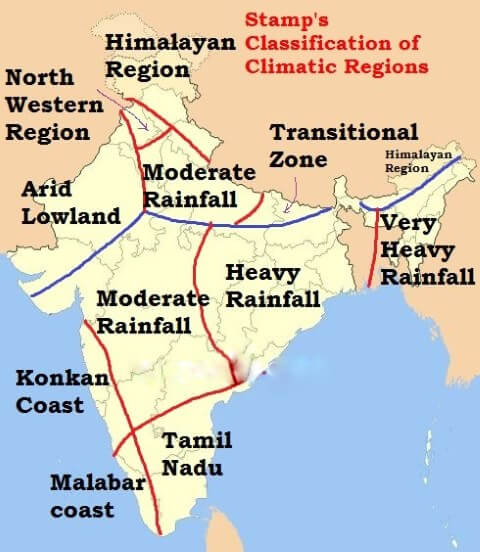
Stamp’s Classification of Climatic Regions of India
• Stamp used 18°C isotherm of mean monthly temperature for January to divide the country into two broad climatic regions, viz., temperate or continental zone in the north and tropical zone in the south.
• This line runs roughly across the root of the peninsula, more or less along or parallel to the Tropic of Cancer.
• The two major climatic regions are further divided into eleven regions depending upon the amount of rainfall and temperature.
- Temperate or Continental India
- The Himalayan region (heavy rainfall)
- The north-western region (moderate rainfall)
- The arid low land
- The region of moderate rainfall
- The transitional zone
- Tropical India
- Region of very heavy rainfall
- Region of heavy rainfall
- Region of moderate rainfall
- The Konkan Coast
- The Malabar Coast
- Tamil Nadu
- Temperate or Continental India
Region Himalayan Region
Avg Temperature Summer = 4°-7°C Winter = 3°-18°C
Annual Rainfall East = Over 200 cm West = much less
North-western Region
Northern parts of Punjab and southern parts of Jammu and Kashmir
Summer = 16°C Below 200 cm
Winter = 24°C
Arid Lowlands
Thar desert of Rajasthan, south western part of Haryana and Kachchh of Gujarat
Winter = 16° to 24°C Below 40 cm
Summer = 48°C
Region of moderate rainfall
Punjab, Haryana, western Uttar Pradesh, Union Territory of Delhi, north-west Plateau area of Madhya Pradesh and eastern Rajasthan
Winter = 15°-18°C 40 – 80 cm
Summer = 33°-35°C
Transitional Zone
Eastern Uttar Pradesh and Bihar
Winter = 15°-19°C 100 -150 cm
Summer = 30° – 35°C
- Tropical India
Region of very heavy rainfall
Meghalaya, Assam, Tripura, Mizoram and Nagaland
Winter = 12-18°C Over 200 cm
Summer = 32°-35°C
Region of heavy rainfall
Chhattisgarh, Jharkhand, Gangetic West Bengal, Odisha and coastal Andhra Pradesh
Winter = 18°-24°C 100 – 200 cm
Summer = 29°-35°C
Region of moderate rainfall
between Western and Eastern Ghats
Winter = 18°-24°C 50 -100 cm
Summer = 32°C
Konkan Coast
Mumbai in the north to Goa in the south
Annual = 24°-27°C. Over 200 cm
Malabar Coast
Goa to Kanniyakumari
Annual = 27°C Over 250 cm
Tamil Nadu
Tamil Nadu and adjoining areas of Andhra Pradesh
Annual = 24°C 100 to 150 cm
(Retreating monsoon)
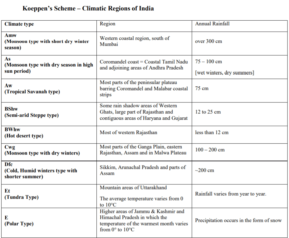
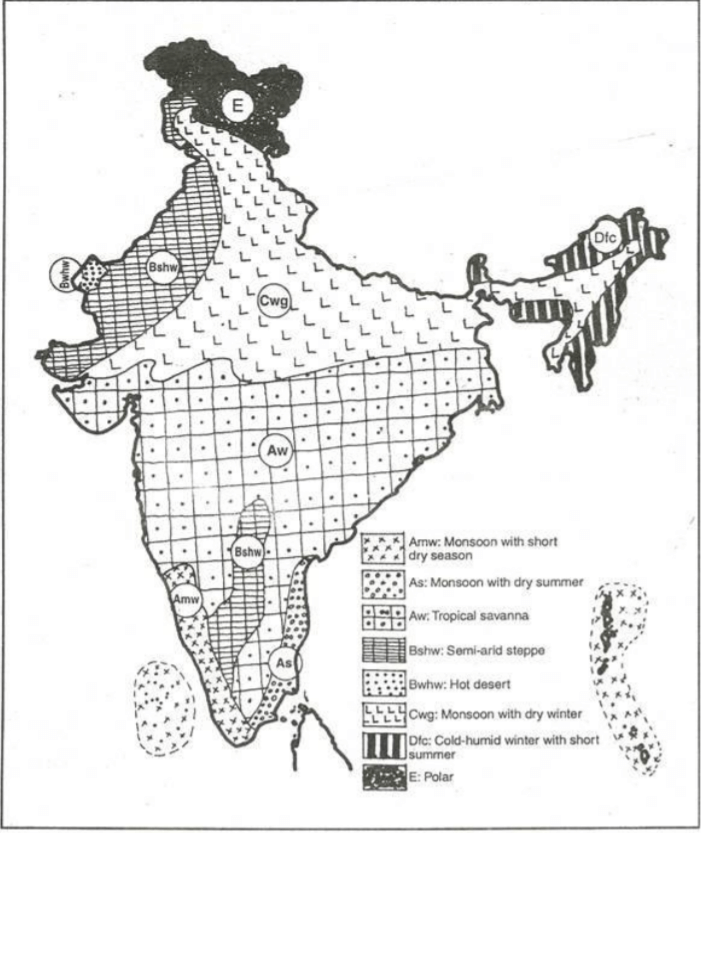
Koeppen’s Classification of Climatic Regions of India
• Koeppen’s Classification of Climatic Regions of India is an empirical classification based on mean annual and mean monthly temperature and precipitation data.
• Koeppen identified a close relationship between the distribution of vegetation and climate.
• He selected certain values of temperature and precipitation and related them to the distribution of vegetation and used these values for classifying the climates.
• Koeppen recognized five major climatic groups, four of them are based on temperature and one on precipitation.
The capital letters:
- A, C, D and E delineate humid climates and
- B dry climates.
• The climatic groups are subdivided into types, designated by small letters, based on seasonality of precipitation and temperature characteristics.
• The seasons of dryness are indicated by the small letters: f, m, w and s, where
- f – no dry season
- m – monsoon climate
- w – winter dry season and
- s – summer dry season
• The above mentioned major climatic types are further subdivided depending upon the seasonal distribution of rainfall or degree of dryness or cold.
a: hot summer, average temperature of the warmest month over 22°C
c: cool summer, average temperature of the warmest month under 22°C
f: no dry season
w: dry season in winter
s: dry season in summer
g: Ganges type of annual march of temperature; hottest month comes before the solstice and the summer rainy season
h: average annual temperature under 18°C
m (monsoon): short dry season
• The capital letters S and W are employed to designate the two subdivisions of dry climate:
- semi-arid or Steppe (S) and
- arid or desert (W)
• Capital letters T and F are similarly used to designate the two subdivisions of polar climate
- tundra (T) and
- icecap (F)