RIVERS OF INDIA
Classification of Drainage Systems of India
Drainage Systems Based on the Size of the Catchment Area
Division Size of catchment area in sq km
Major river 20,000
Medium river 20,000 – 2,000
Minor river 2,000 and below
Drainage Systems Based on Origin
The Himalayan Rivers: Perennial rivers: Indus, the Ganga, the Brahmaputra and their tributaries.
The Peninsular Rivers: Non-Perennial rivers: Mahanadi, the Godavari, the Krishna, the Cauvery, the Narmada and the Tapi and their tributaries.
Drainage Systems Based on the Type of Drainage
The river systems of India can be classified into two groups viz.
Himalayan rivers, Deccan rivers and Coastal rivers that drain into the sea.
Rivers of the inland drainage basin (endorheic basin): Streams in western Rajasthan are mainly seasonal in character, draining into the inland basins and salt lakes like Sambhar. In the Rann of Kutch, the only river that flows through the salt desert is the Luni.
Drainage Systems Based on Orientation to the sea
The Bay of Bengal drainage (Rivers that drain into Bay of Bengal)(East flowing rivers)
Arabian sea drainage (Rivers that drain into Arabian sea)(West flowing rivers).
Himalayan River Systems
The Indus, the Ganga and the Brahmaputra comprise the Himalayan river systems.
The Himalayan Rivers existed even before the formation of Himalayas i.e. before the collision of Indian Plate with the Eurasian plate. {Antecedent Drainage}
They were flowing into the Tethys Sea. These rivers had their source in the now Tibetan region.
The deep gorges of the Indus, the Satluj, the Brahmaputra etc. clearly indicate that these rivers are older than the Himalayas.
They continued to flow throughout the building phase of the Himalayas; their banks rising steeply while the beds went lower and lower due to vertical erosion (Vertical down cutting was significant and was occurring at a rate faster than the rising of Himalayas), thus cutting deep gorges.
Thus, many of the Himalayan Rivers are typical examples of antecedent drainage.
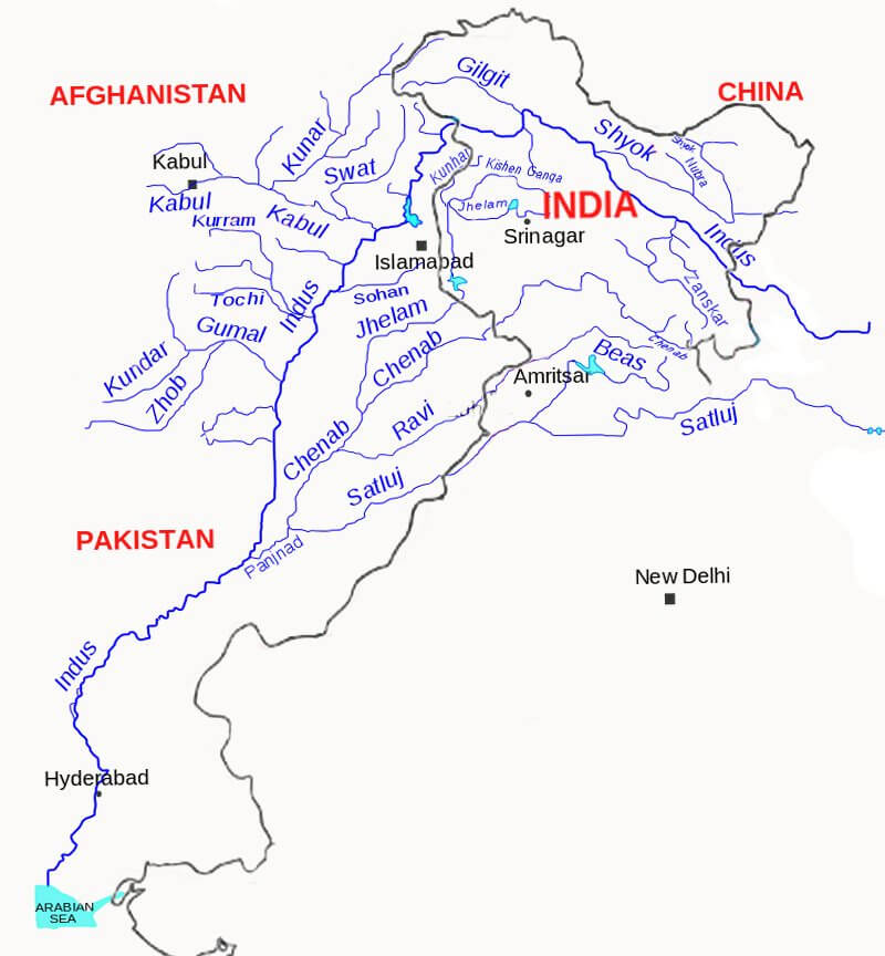
Indus River System
| Major Rivers of Indus River System | Source | Length |
| Indus | Glaciers of Kailas Range (Close to Manasarovar Lake) | 2880 km total, 710 km in India |
| Jhelum | Verinag | 720 km |
| Chenab | Bara Lacha Pass | 1180 km |
| Ravi | Near Rohtang Pass | 725 km |
| Beas | Near Rohtang Pass | 460 km |
| Satluj | Manasarovar-Rakas Lakes | 1450 km total 1050 km in India |
Indus River
India got her name from Indus.
‘The Indus Valley Civilization’ was born around this river.
It flows in north-west direction from its source (Glaciers of Kailas Range – Kailash range in Tibet near Lake Manasarovar) till the Nanga Parbhat Range.
It’s length is about 2,900 km. Its total drainage area is about 1,165,000 square km [more than half of it lies in semiarid plains of Pakistan]. It is joined by Dhar River near Indo-China border.
After entering J&K it flows between the Ladakh and the Zaskar Ranges. It flows through the regions of Ladakh, Baltistan and Gilgit.
The gradient of the river in J&K is very gentle (about 30 cm per km).
Average elevation at which the Indus flows through JK is about 4000 m above sea level.
It is joined by the Zaskar River at Leh (these kind of points are important for prelims).
Near Skardu, it is joined by the Shyok at an elevation of about 2,700 m.
The Gilgit, Gartang, Dras, Shiger, Hunza are the other Himalayan tributaries of the Indus.
It crosses the Himalayas (ends its mountainous journey) through a 5181 m deep gorge near Attock, lying north of the Nanga Parbat. It takes a sharp southerly bend here (syntaxial bend).
Kabul river from Afghanistan joins Indus near Attock. Thereafter it flows through the Potwar plateau and crosses the Salt Range (South Eastern edge of Potwar Plateau).
Some of the important tributaries below Attock include the Kurram, Toch and the Zhob-Gomal.
Just above Mithankot, the Indus receives from Panjnad (Panchnad), the accumulated waters of the five eastern tributaries—the Jhelum, the Chenab, the Ravi, the Beas and the Satluj.
The river empties into the Arabian Sea south of Karachi after forming a huge delta.
Major Tributaries of Indus River
Jhelum River
The Jhelum has its source in a spring at Verinag in the south-eastern part of the Kashmir Valley.
It flows northwards into Wular Lake (north-western part of Kashmir Valley). From Wular Lake, it changes its course southwards. At Baramulla the river enters a gorge in the hills.
The river forms steep-sided narrow gorge through Pir Panjal Range below Baramula.
At Muzaffarabad, the river takes a sharp hairpin bend southward.
Thereafter, it forms the India-Pakistan boundary for 170 km and emerges at the Potwar Plateau near Mirpur.
After flowing through the spurs of the Salt Range it debouches (emerge from a confined space into a wide, open area) on the plains near the city of Jhelum.
It joins the Chenab at Trimmu.
The river is navigable for about 160 km out of a total length of 724 km.
Chenab River
The Chenab originates from near the Bara Lacha Pass in the Lahul-Spiti part of the Zaskar Range.
Two small streams on opposite sides of the pass, namely Chandra and Bhaga, form its headwaters at an altitude of 4,900 m.
The united stream Chandrabhaga flows in the north-west direction through the Pangi valley, parallel to the Pir Panjal range.
Near Kistwar, it cuts a deep gorge.
It enters the plain area near Akhnur in Jammu and Kashmir.
From here it through the plains of Pakistani Punjab to reach Panchnad where it joins the Satluj after receiving the waters of Jhelum and Ravi rivers.
Ravi River
The Ravi has its source in Kullu hills near the Rohtang Pass in Himachal Pradesh.
It drains the area between the Pir Panjal and the Dhaola Dhar ranges.
After crossing Chamba, it takes a south-westerly turn and cuts a deep gorge in the Dhaola Dhar range.
It enters Punjab Plains near Madhopur and later enters Pakistan below Amritsar.
It debouches into the Chenab a little above Rangpur in Pakistani Punjab.
Beas River
The Beas originates near the Rohtang Pass, at a height of 4,062 m above sea level, on the southern end of the Pir Panjal Range, close to the source of the Ravi.
It crosses the Dhaola Dhar range and it takes a south-westerly direction and meets the Satluj river at Harike in Punjab.
It is a comparatively small river which is only 460 km long but lies entirely within the Indian territory.
Satluj River
The Satluj rises from the Manasarovar-Rakas Lakes in western Tibet at a height of 4,570 m within 80 km of the source of the Indus.
Like the Indus, it takes a north-westerly course upto the Shipki La on the Tibet-Himachal Pradesh boundary.
It cuts deep gorges where it pierces the Great Himalaya and the other Himalayan ranges.
Before entering the Punjab plain, it cuts a gorge in Naina Devi Dhar, where the famous Bhakra dam has been constructed.
After entering the plain at Rupnagar (Ropar), it turns westwards and is joined by the Beas at Harike.
From near Ferozepur to Fazilka it forms the boundary between India and Pakistan for nearly 120 km.
During its onward journey it receives the collective drainage of the Ravi, Chenab and Jhelum rivers. It joins the Indus a few kilometres above Mithankot.
Out of its total length of 1,450 km, it flows for 1,050 km in Indian territory.
Indus water treaty
The waters of the Indus river system are shared by India and Pakistan according to the Indus Water Treaty signed between the two countries on 19th September, 1960.
According to this treaty, India can utilize only 20 per cent of its total discharge of water.
Ganga River System

River Source
Bhagirathi (Ganga) Gangotri glacier
Yamuna Yamnotri glacier on the Bandarpunch Peak
Chambal Janapao Hills in the Vindhya Range
Banas Aravali Range
Betwa Bhopal district
Ken Barner Range
Son Amarkantak Plateau
Damodar (‘Sorrow of Bengal’) Chotanagpur plateau
Ramganga Garhwal district of Uttarakhand
Ghaghra Gurla Mandhata peak, south of Manasarovar in Tibet (river of the trans-Himalayan origin)
Kali (border between Nepal and Uttarakhand) Glaciers of trans-Himalayas
Gandak Tibet-Nepal border
Burhi Gandak Sumesar hills near the India-Nepal border
Kosi (‘Sorrow of Bihar’) Tumar, Arun and Sun Kosi unite at Triveni north of the Mahabharata Range to form the Kosi
Ganga River
The Ganga originates as Bhagirathi from the Gangotri glacier in Uttar Kashi District of Uttarakhand at an elevation of 7,010 m.
Alaknanda River joins Bhagirathi at Devaprayag.
From Devapryag the river is called as Ganga.
Pollution threatens many fish species and amphibian species and the endangered Ganges river dolphin (Blind Dolphin).
Major tributaries of Alaknanda
East Trisul (joins Alaknanda at Karan Prayag)
Pindar (rises from Nanda Devi)
Mandakini or Kali Ganga (joins Alaknanda at Rudra Prayag)
Dhauliganga
Bishenganga.
Ganga debouches [emerges from a confined space into a wide, open area] from the hills into the plains at Haridwar.
It is joined by the Yamuna at Allahabad.
Near Rajmahal Hills it turns to the south-east.
At Farraka, it bifurcates into Bhagirathi-Hugli in West Bengal and Padma-Meghna in Bangladesh (it ceases to be known as the Ganga after Farraka).
Brahmaputra (or the Jamuna as it is known here) joins Padma-Meghna at Chandpur in Bangladesh.
It then flows into the Bay of Bengal as the Meghna River.
The total length of the Ganga river from its source to its mouth (measured along the Hugli) is 2,525 km.
Ganga – Brahmaputra Delta
Before entering the Bay of Bengal, the Ganga, along with the Brahmaputra, forms the largest delta of the world between the Bhagirathi/Hugli and the Padma/Meghna covering an area of 58,752 sq km.
The coastline of delta is a highly indented area.
The delta is made of a web of distributaries and islands and is covered by dense forests called the
A major part of the delta is a low-lying swamp which is flooded by marine water during high tide.
Right Bank Tributaries of Ganga
Most of them except Yamuna originate in the peninsular region.
Yamuna River
Largest and the most important tributary.
It originates from the Yamnotri glacier on the Bandarpunch Peak in the Garhwal region in Uttarakhand at an elevation of about 6,000 meters.
It cuts across the Nag Tibba, the Mussoorie and the Shiwalik ranges.
It emerges out of the hilly area and enters plains near
Its main affluent in the upper reaches is the Tons which also rises from the Bandarpunch glacier.
It joins Yamuna below Kalsi before the latter leaves the hills.
At this site, the water carried by the Tons is twice the water carried by the Yamuna.

Tributaries of Yamuna
Non – Peninsular Tributaries
1. Rishiganga
2. Uma
3. Hanuman Ganga and
4. Tons (joins it in the mountains)
5. Hindon (joins at Ghaziabad in the plain area)
Peninsular Tributaries
Most of the Peninsular Rivers flow into the Yamuna between Agra and Allahabad.
1. Chambal
2. Sind
3. Betwa
4. Ken
Yamuna unites with the Ganga near Triveni Sangam, Allahabad.
The total length of the Yamuna from its origin till Allahabad is 1,376 km.
It creates the highly fertile alluvial, Yamuna-Ganges Doab region between itself and the Ganges in the Indo-Gangetic plain.
Chambal River
The Chambal rises in the highlands of Janapao Hills (700 m) in the Vindhyan Range.
It flows through the Malwa Plateau.
It joins the Yamuna in Etawah district of Uttar Pradesh.
The river flows much below its banks due to severe erosion because of poor rainfall and numerous deep ravines have been formed in the Chambal Valley, giving rise to badland topography. {Arid Landforms}
The total length of the river is 1,050 km.
Dams on the Chambal
The Gandhi Sagar dam is the first of the four dams built on the Chambal River, located on the Rajasthan-Madhya Pradesh border.
The Rana Pratap Sagar dam is a dam located 52 km downstream of Gandhi Sagar dam on across the Chambal River in Chittorgarh district in Rajasthan.
The Jawahar Sagar Dam is the third dam in the series of Chambal Valley Projects, located 29 km upstream of Kota city and 26 km downstream of Rana Pratap Sagar dam.
The Kota Barrage is the fourth in the series of Chambal Valley Projects, located about 0.8 km upstream of Kota City in Rajasthan.
Water released after power generation at Gandhi Sagar dam, Rana Pratap Sagar dam and Jawahar Sagar Dams, is diverted by Kota Barrage for irrigation in Rajasthan and in Madhya Pradesh through canals.
Keoladeo National Park is supplied with water from Chambal river irrigation project.
Banas River
The Banas is a tributary of the Chambal.
It originates in the southern part of the Aravali Range.
It join the Chambal on Rajasthan – Madhya Pradesh border near Sawai Madhopur.
Sind River
The Sind originates in Vidisha Plateau of Madhya Pradesh.
It flows for a distance of 415 km before it joins the Yamuna.
Betwa River
The Betwa rises in Bhopal district (Vindhyan Range) and joins the Yamuna near
It has a total length of 590 km.
The Dhasan is its important tributary.
Ken River
The Ken river rising from the Barner Range of Madhya Pradesh joins the Yamuna near Chila.
Son River
The Son River rises in the Amarkantak Plateau.
Its source is close to the origin of the Narmada.
It passes along the Kaimur Range.
It joins the Ganga near Danapur in Patna district of Bihar.
It flows for a distance of 784 km from its source.
The important tributaries of the Son are the Johilla, the Gopat, the Rihand, the Kanhar and the North Koel. Almost all the tributaries join it on its right bank.
Damodar river
The Damodar river rises in the hills of the Chotanagpur plateau and flows through a rift valley.
Rich in mineral resources, the valley is home to large-scale mining and industrial activity.
It has a number of tributaries and subtributaries, such as Barakar, Konar, Bokaro, Haharo, etc.
The Barakar is the most important tributary of the Damodar.
Several dams have been constructed in the valley, for the generation of hydroelectric power. The valley is called “the Ruhr of India”.
The first dam was built across the Barakar River, a tributary of the Damodar river.
It used to cause devastating floods as a result of which it earned the name ‘Sorrow of Bengal’. Now the river is tamed by constructing numerous dams.
It joins the Hugli River 48 km below Kolkata.
The total length of the river is 541 km.
Left Bank Tributaries of The Ganga River
These rivers originate in the Himalayas.
The major tributaries apart from the Yamuna, are the Ramganga, the Gomati, the Ghaghra, the Gandak, the Burhi Gandak, the Bagmati, and the Kosi.
Ramganga River
The Ramganga river rises in the Garhwal district of Uttarakhand.
It enters the Ganga Plain near Kalagarh.
It joins the Ganga at
The Khoh, the Gangan, the Aril, the Kosi, and the Deoha (Gorra) are important tributaries of Ramganga.
Ghaghra River
Its source is near Gurla Mandhata peak, south of Mansarovar in Tibet (river of the trans-Himalayan origin).
It is known as the Karnaili in Western Nepal.
Its important tributaries are the Sarda, the Sarju (Ayodhya is located on its bank) and the Rapti.
The Ghaghara joins the Ganga a few kilometres downstream of Chhapra in Bihar.
After reaching the plain area, its stream gets divided into many branches of which, Koriyab and Garwa are important.
The river bed is sandy and sudden bends start occurring in the stream.
The river has a high flood frequency and has shifted its course several times.
Kali River
Rises in the high glaciers of trans-Himalaya.
It forms the boundary between Nepal and Kumaon.
It is known as the Sarda after it reaches the plains near Tanakpur.
Gandak River
Originates near the Tibet-Nepal border at a height of 7,620 m
It receives a large number of tributaries in Nepal Himalaya.
Its important tributaries are the Kali Gandak, the Mayangadi, the Bari and the Trishuli.
It flows into Ganga at Hajipur in Bihar
Burhi Gandak
Originates from the western slopes of Sumesar hills near the India-Nepal border
It joins the Ganga near Monghyr town
Kosi River
The Kosi river consists of seven streams namely Sut Kosi, Tamba Kosi, Talkha, Doodh Kosi, Botia Kosi, Arun and Tamber and is popularly known as Sapt Kosi
These streams flow through eastern Nepal which is known as the Sapt Kaushik region.
The sources of seven streams of the Kosi are located in snow covered areas which also receive heavy rainfall.
Consequently, huge volume of water flows with tremendous speed.
Seven streams mingle with each other to form three streams named the Tumar, Arun and Sun Kosi.
They unite at Triveni north of the Mahabharata Range to form the Kosi.
The river enters the Tarai of Nepal after cutting a narrow gorge in the Mahabharata Range.
The joins the Ganga near Kursela.
Soon after debouching onto the plain the river becomes sluggish.
Large scale deposition of eroded material takes place in the plain region.
The river channel is braided and it shifts its course frequently. This has resulted in frequent devastating floods and has converted large tracts of cultivable land into waste land in Bihar. Thus the river is often termed as the ‘Sorrow of Bihar’.
In order to tame this river, a barrage was constructed in 1965 near Hanuman Nagar in Nepal.
Embankments for flood control have been constructed as a joint venture of India and Nepal.
Brahmaputra River System
Region Name
Tibet Tsangpo (meaning ‘The Purifier’)
China Yarlung Zangbo
Assam Valley Dihang or Siong, South of Sadiya: Brahmaputra
Bangladesh Jamuna
Padma: Combined Waters of Ganga and Brahmaputra
Meghna: From the confluence of Padma and Meghna
Brahmaputra river system is one of the largest rivers in the world. In the Tibet region, it is known by the name of Yarlung Tsangpo. It enters by the names of Siang and Dihang in India. And after it is joined by its two main tributaries, the Dibang and the Lohit, it is known by the name of Brahmaputra. It flows in Bangladesh by the name of Jumna. Finally, it merges with the Ganga river.
Brahmaputra River System
The world’s largest riverine island, Majuli Island is on the Brahmaputra river in the state of Assam. Important cities along Brahmaputra are Dibrugarh, Pasighat, Neamati, Tezpur and Guwahati.
Source of origin: The Brahmaputra river rises from Chemayundung glacier of the Kailash range near the Mansarovar Lake to the north of the Himalayas in the southwest Tibet region.
Confluence of Mouth: The Brahmaputra drains into the Bay of Bengal before forming a huge delta along with the Ganga.
Course of the Brahmaputra river
In Tibet, it runs parallel to the Himalayas for about 1,200 km. It turns into the south and creates a deep gorge through the Himalayas near Namcha Barwa and enters India under the name of the Dihang. Near Sadia, it receives the Dibang coming from the north and the Lohit coming from the east and enters the Assam valley where it is called the Brahmaputra. It flows in the west direction up to Dhubri and further below, it runs to the south and enters Bangladesh.
The Brahmaputra receives numerous tributaries in the Assam valley. The number of streams joining the Brahmaputra on its right-bank is greater than that of those joining it on the left-bank. Most of the tributaries are large streams and they pour great quantities of water in the Brahmaputra. During the rainy season, it is 8 km broad, slow-moving and heavily laden with silt. Its channel is braided. It is notorious for floods and erosion of its banks. Recurrent floods not only hampers the navigation through the river but also the establishment of large towns on its banks.
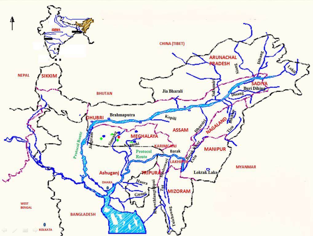
Primary Tributaries of the Brahmaputra River
Dhansiri
It is the left-bank tributary of the Brahmaputra river.It rises from Liasang peak of Nagaland. It is the main river of the Golaghat district of Assam and the Dimapur district of Nagaland.
Lohit
It is an important left-bank tributary of the Brahmaputra river. It rises in the eastern Tibet region. The Lohit river flows through the Mishmi Hills. It joins the left-bank of the Brahmaputra at Sadia town in the state of Arunachal Pradesh. The main human habitations along the river are the cities of Lohit and Brahmakund. The catchment area of the Lohit river is covered extensively by thick forests. The newly constructed massive Dhola-Sadia bridge or the Bhupen Hazarika bridge spans the Lohit river.
Dibang
It is the left-bank tributary of the Brahmaputra river. It is one of the principal tributaries of the Brahmaputra river. It flows through the states of Arunachal Pradesh and Assam. It enters the plain area in Lower Dibang Valley district of Arunachal Pradesh. It enters Assam plains near Roing.
Subansiri
It is the right-bank tributary of the Brahmaputra river. It rises in the Tibet region in the Himalayas. It flows east and southeast through the Lower Subansiri district in Arunachal Pradesh, and then south to the Assam valley, where it joins the right-bank of the Brahmaputra river in the Lakhimpur district of Assam. The Subansiri River is known as the Gold River by the locals. This river is famous all over the world for its gold dust.
Kameng
It is the right-bank tributary of the Brahmaputra river. It rises in the Tawang district in the eastern Himalayas. It forms the border between the East Kameng district and the West Kameng district of Arunachal Pradesh. In Assam, it flows through the Sonitpur district before joining the Brahmaputra at Tezpur. The Kameng River consists of two sections- the west consisting of the Akka hills and resided by the Akka tribes and the east consisting of the Dafla hills resided by the Daphla tribe. The Kaziranga National Park and the Pakkhui Wildlife Sanctuary are located near the Kameng river.
Manas
It is the right-bank tributary of the Brahmaputra river. It is a trans-boundary river in the Himalayan foothills between southern Bhutan and India. It is named after Manasa, the serpent god in the Hindu mythology. Royal Manas National Park of Bhutan and the Manas Wildlife Sanctuary are located in the Manas River valley. The Manas river flows through Bhutan and Assam in India before it joins the right-bank of the Brahmaputra river.
Sankosh
It is the right-bank tributary of the Brahmaputra river. It is a trans0boundary river and it flows through Bhutan, India, and Bangladesh. It rises in the northern Bhutan region. It then flows through the region bordering the West Bengal district of Jalpaiguri and the districts of Dhubri and Kokrajhar in Assam. It then crosses over to Bangladesh where it is known by the name of Dudhkumar River. The river finally joins the right-bank of the Brahmaputra river near the Indo-Bangladesh border.
Teesta
It is the right-bank tributary of the Brahmaputra river. The Teesta rises from Zemu glacier in Kanchenjunga massif in Sikkim. The Teesta river drains the entire state of Sikkim and a part of Darjeeling Hills. It is known as the lifeline of Sikkim. The Teesta flows along a very deep gorge which divides north Bengal or the hills of Darjeeling into two parts-Tiger Hill range in the west and the Kalimpong Hill range in the east. It joins the Brahmaputra on its right-bank in Bangladesh.
Major River Valley Projects/Dams/Barrages associated with the Brahmaputra river system-
In the state of Arunachal Pradesh–
- Tawang Hydel Power Project
- Subansiri Lower Hydel Power Project
- Ranganadi Hydel Power Project
- Paki Hydel Power Project
- Papumpap Hydel Power Project
- Dhinkrong Hydel Power Project
- Upper Lohit Hydel Power Project
- Damway Hydel Power Project
- Kameng Hydel Power Project
In the state of Sikkim–
- Rangit Hydel Power Project
- Teesta Hydel Power Project
In the state of Assam–
- Kopli Hydel Power Project
In the state of Meghalaya–
- New Umtru Hydel Power Project
In the state of Nagaland–
- Doyang Hydel Power Project
In the state of Manipur–
- Loktak Hydel Power Project
- Tipaimukh Hydel Power Project
In the state of Mizoram–
- Tuibai Hydel Power Project
- Tuirial Hydel Power Project
- Dhaleshwari Hydel Power Project
Peninsular river system
The Peninsular river system is older than the Himalayan river system. It is evident from the broad, largely-graded shallow valleys, and the maturity of the rivers.
The Western Ghats running close to the western coast is the main water divide between the major Peninsular rivers, discharging their waters in the Bay of Bengal and as small rivulets joining the Arabian Sea.
Most of the major Peninsular rivers except Narmada, Tapi, Sabarmati and Mahi flow towards the west. Mahanadi, Kaveri, Godavari, Krishna rivers have a fixed course and there is an absence of meanders, and the flow of water is non-perennial. And Narmada and Tapi flow through the rift valley.
Evolution of the Peninsular Drainage
Three major events in the geological history of India has lead to the present drainage pattern in Peninsular India
During the tertiary period, the western part of the peninsula cracked and submerged in the sea. This even lead to the creation of various rift and trough. Also, the initial symmetrical pattern of drainage on either side of Sahyadri-Aravali axis changed forever through this event.
The formation of Himalayas leads to the subsidence of the Northern flank of the peninsular block and the creation of rift valleys. These rift valleys are drained by the Narmada and Tapi rivers.
Slight tilting of the peninsular block from northwest to the south-eastern direction gave orientation to the entire drainage system towards the Bay of Bengal during the same period.

Peninsular India is sapped by following major river systems:
- Narmada
- Tapi
- Luni
- Sabarmati, Mahi
- Ghagghar
- Godavari
- Mahanadi
- Pennar
- Krishna
- Kaveri
- Subarnarekha, Vaigai
Comparison between the Himalayan River System and the Peninsular River System:
While the Himalayan rivers originate from the Himalayan mountains covered with glaciers, the Peninsular rivers originate from the Peninsular plateau and central highland.
The Himalayan rivers are perennial in nature and receive water from the glaciers and rainfall. Whereas, the Peninsular rivers are seasonal in nature and are dependent on monsoon rainfall.
The drainage pattern of the Himalayan rivers and the Peninsular rivers also differ. The Himalayan rivers are antecedent and consequent leading to dendritic drainage pattern in the plains. On the other hand, the Peninsular rivers are super-imposed and rejuvenated leading to trellis, radial and rectangular drainage pattern.
The Himalayan rivers usually have a long course. They flow through the rugged mountains and experience headward erosion and river capturing. In the plains, the Himalayan rivers are characterised by meandering and shifting of course. Whereas, the Peninsular rivers have smaller and fixed course with well-adjusted valleys.
The Himalayan rivers have very large basins as their catchment area, whereas, the Peninsular rivers have relatively smaller basins.
The Himalayan river system is young and youthful, and the rivers are active and deepening in the valleys. The Peninsular river system, however, is older. The rivers are broad and have largely-graded shallow valleys having almost reached their base levels.
Godavari
The Godavari river is the largest river of Peninsular India. It is known as the Dakshin Ganga or Vridha Ganga (old Ganga) because of its age, size and length. It is navigable in the delta region.
Source of origin of the Godavari river: It rises from a place called Trimbak located in the Western Ghats in Nashik district in the state of Maharashtra.
Confluence or mouth of the Godavari river: It drains into the Bay of Bengal before forming a large delta below Rajahmundry.
Major Tributaries of the Godavari river
- Indravati
- Pranhita
- Wardha
- Penganga
- Purna
- Duhna
- Manjra
- Wainganga
- Sabari
Godavari basin
The Godavari river flows through the states of Maharashtra, Telangana, Andhra Pradesh, Chhattisgarh, Madhya Pradesh, Odisha, Karnataka and Puducherry. The Godavari basin is bounded by Satmala hills on the north, Ajanta range and Mahadeo hills on the south, the Eastern Ghats on the east and the Western Ghats on the west.
Major River Valley Projects/Dams/Barrages associated with the Godavari river system:
Gangapur Dam– The dam has been constructed across the Godavari in Nashik district in the state of Maharashtra. The reservoir created by the dam is known as Gangapur Bandh Sagar.
Jayakwadi Dam– The dam has been constructed across the Godavari river near Paithan in the state of Maharashtra. It aims to address the dual problems of flooding along the banks during monsoon months, and that of drought during the rest of the year, particularly in Marathwada region.
Sriram Sagar Project– The project has been executed across the Godavari river in Nizamabad district in the state of Telangana.
Polavaram Project– The Polavaram project is being executed across the Godavari river in the state of Andhra Pradesh.
Dowleswaram Barrage– The barrage was built by Sir Arthur Cotton, a British engineer in 1852. It is located in Rajahmundry in the state of Andhra Pradesh.
Other facts related to the Godavari river system:
Godavari is subjected to heavy floods in its lower reaches to the south of Polavaram, where it forms a picturesque gorge.
The coastal areas in the Godavari basin are cyclone-prone.
The deltaic areas of the Godavari basin face drainage congestion due to flat topography.
A large portion of Maharashtra, the Marathwada region in the Godavari basin is drought prone.
Some important cities on the banks of Godavari river are Nashik, Bhadrachalam, Rajahmundry and Narsapur.
Asia’s largest rail-cum-road bridge, the Godavari bridge linking Kovvur and Rajahmundry is considered to be an engineering feat.
Krishna
Krishna is the second largest east-flowing river of Peninsular India.
Source of origin of the Krishna river: It rises from a water spring near Mahabaleshwar located in the Sahyadri hills region of the Western Ghats in the state of Maharashtra.
Confluence or mouth of the Krishna river: It drains into the West Bengal before forming a delta near Hamasaladeevi in the state of Andhra Pradesh.
The Krishna basin is surrounded by the Godavari basin on the north and the Eastern Ghats on the south and east and the Western Ghats on the west. The Krishna basin is roughly triangular in shape.
Major Tributaries of Krishna:
- Tungabhadra
- Bhima
- Koyna
- Verna
- Panchganga
- Ghataprabha
- Malprabha
- Dudhganga
- Musi
Krishna basin:
The Krishna River flows through the states of Maharashtra, Karnataka and Andhra Pradesh and Telangana.
Major River Valley Projects/Dams/Barrages associated with the Krishna river system:
Tungabhadra Project– The project aims at producing hydro-electricity, providing irrigation water and municipal water supply and controlling floods in the region. Under this project, a dam has been constructed across the Tungabhadra river near Hospet in the state of Karnataka.
Srisailam Project– Under the project, a large dam has been constructed across the Krishna river in Kurnool district in the state of Andhra Pradesh. It has created a reservoir named as Srisailam Sagar or Neelam Sanjjeva Reddy Sagar.
Nagarjuna Sagar Dam– The construction of the dam started in 1950, being one of the earliest large infrastructure project of India, aimed at bringing Green Revolution. The dam has been constructed across the Krishna river straddling the borders of Nalgonda and Guntur districts.
Prakasam Barrage– The Prakasam Barrage was conceptualised by Major Cotton of the East India Company. It is constructed across the Krishna river near Vijayawada in the state of Andhra Pradesh.
Ghatprabha Project– The project has been executed across the Ghatprabha river near Chandgad in Kolhapur district in the state of Maharashtra in the Krishna river basin.
Bhima Project– The project has been executed across the Bhima river in Solapur district in the state of Maharashtra in the Krishna river basin.
Mahanadi
Mahanadi River system is the third largest of peninsular India and the largest river of Odisha state. The word Mahanadi is a compound of the two Sanskrit words maha which means”great” and nadi which means”river”.
Source or origin of the Mahanadi
It rises from a place near Sihawa in Bastar hills in the state of Chhattisgarh to the south of Amarkantak.
Confluence or mouth of Mahanadi
The Mahanadi river drains into the Bay of Bengal after being divided into different branches in the deltaic area. The main branches of River Mahanadi meet the Bay of Bengal at Paradip and Nuagarh (Devi estuary).
Major Tributaries of Mahanadi:
- Seonath
- Hasdeo
- Mand
- Ib
- Jonking
- Tel
The course of Mahanadi
Mahanadi flows through the states of Chhattisgarh, Madhya Pradesh, Odisha, Jharkhand and Maharashtra. The Mahanadi basin is bounded by the Central India hills on the north, by the Eastern Ghats on the south and east and by the Maikala range on the west.
Major River Valley Projects/Dams/Barrages associated with Mahanadi river system
Hirakud – It is one of the first major multipurpose river valley projects started after India’s independence. The dam aims at controlling floods in the Mahanadi basin, providing water for irrigation and municipal water supply. The dam is located near Sambalpur in the state of Odisha.
Gangrel – It is also known by the name of R.S. Sagar Dam. The dam is built across the Mahanadi river in Dhamtari district in the state of Chhattisgarh.
Dhudhwa – The dam is constructed across the Mahanadi river in Dhamtari district in the state of Chhattisgarh.
Issues related to Mahanadi river system
Mahanadi river basin is subject to severe flooding occasionally in the delta area due to an inadequate carrying capacity of the channels. The multi-purpose Hirakud river valley project provides some amount of flood relief by storing part of flood water. However, the problem still persists and a lasting solution needs to be evolved.
Kaveri
The Kaveri river also spelt Cauvery is the longest river of Peninsular India. And the Kaveri is also the third largest river after Godavari and Krishna in south India and the largest in Tamil Nadu which on its course, bisects the state into North and South.
The Kaveri river has water flow throughout the year because it gets rainwater from south-west monsoons in the upper-catchment area (located in Karnataka) and from the north-east monsoons in the lower-catchment area (located in Tamil Nadu).
Source of origin of Kaveri
Kaveri rises from Taalkaveri in the hills of Brahmagiri in Coorg district in the state of Karnataka.
Confluence or mouth of Kaveri
Kaveri drains its waters into the Bay of Bengal before forming a wide delta called the garden of southern India.
Major Tributaries of the Kaveri river
- Laxmantiratha
- Kabani
- Suvarnavati
- Noyil
- Bhavani
- Amravati
- Herangi
- Hemavati
- Shimsha
- Akrawati
Kaveri basin
Kaveri river flows in Karnataka, Tamil Nadu and a small river basin also lie in Kerala and union territory of Puducherry. It is bounded by the Western Ghats on the west, by the Eastern Ghats on the east and the south and by the ridges separating it from Krishna basin and Pennar basin on the north.
Major River Valley Projects/Dams/Barrages associated with the Kaveri river system
Krishnarajsagar Dam– The dam has been constructed across the Kaveri river in Mandya district in the state of Karnataka. The primary purpose of the dam is to supply irrigation water in the region and increase agriculture production and productivity.
Kabani Dam– The Kabani Dam has been constructed in Mysore district in the state of Karnataka. The dam generates hydro-electricity and provides irrigation water in the region.
Harangi Dam– The Harangi dam has been constructed across the Harangi river (tributary of Kaveri) in Kodagu district in the state of Karnataka.
Hemavathy Dam– The multipurpose dam has been constructed across the Kaveri river in Hassan district in the state of Karnataka.
Mettur Dam– The multipurpose dam has been constructed across the Kaveri river in Mettur in Salem district in the state of Tamil Nadu.
Kodaganar Dam– The Kodaganar dam has been constructed across the Kaveri river in Dindigul district in the state of Tamil Nadu.
Nanganjiyar Dam- The Nanganjiyar dam has been constructed across the Nanganjiyar river in Dindigul district in the state of Tamil Nadu.
Other facts related to Kaveri river system
Shivasundaram falls, the second largest waterfalls in India is on the Kaveri river in Mandya District in Karnataka.
Important industries in the basin include cotton textile industry in Coimbatore and Mysore, cement factories in Coimbatore and Trichinapally and industries based on mineral and metals. The Salem steel plant and many engineering industries in Coimbatore and Trichinapally are also situated in the Kaveri basin.
The waters of Kaveri have supported irrigated agriculture for centuries, and it has been the lifeblood of the ancient kingdoms and modern cities of South India.
Subarnarekha River
The Subarnarekha is one of the longest east flowing inter-state rivers.
Source/ origin of the Subarnarekha river:
It rises from the Chotanagpur plateau near Nagri village in Ranchi District in Jharkhand.
Confluence or mouth of the Subarnarekha river:
Subarnarekha river drains its waters into the Bay of Bengal.
Primary Tributaries of Subarnarekha
Kanchi
Karkari
Kharkai
Dulang
Subarnarekha river basin
Subernarekha basin extends over states of Jharkhand, Odisha and comparatively smaller part in West Bengal. The basin is located in the north-east corner of Peninsular India. It is bounded by the Chhotanagpur plateau on the north and the west, by the ridges separating it from Baitarani basin on the south, by the Bay of Bengal on the south-east and by the Kasai Valley of Kangsabati River on the east.
Major River Valley Projects/Dams/Barrages associated with the Subarnarekha river system:
Getalsud Project– A dam is constructed across the Subarnarekha river in Ranchi district in the state of Jharkhand.
Subarnarekha Multi-Purpose Project– It is a joint project of the states of Jharkhand, West Bengal and Odisha. Under the project, the Chandil dam, the Icha dam, the Kharkai barrage and the Galudih barrage have been constructed.
Other characteristics of the Subarnarekha river system:
The picturesque Hundru Falls is created on the course of the Subarnarekha river