MAJOR PHYSICAL DIVISIONS OF INDIA
- The Himalayas (young fold mountains)
- Indo-Gangetic Plain (monotonous topography – featureless topography)
- The Peninsular Plateau (one of the most stable landmasses; one of the oldest plateaus of the world)
- Coastal Plains (Sediments due to fluvial action).
- The Islands [Coral Islands == coral reef built up on atolls – Lakshadweep. Tectonic Islands == Andaman and Nicobar Islands]
Himalayas
• Includes the Himalayas, Purvanchal and their extensions Arakan Yoma (Myanmar) and Andaman and Nicobar Islands (but we will consider these as islands only).
• It is the youngest and highly unstable landmass of India. [Continent – Continent Convergence]
• Tectonic movements are very common.
Peninsular Plateau
• Includes the entire south India, central India, Aravalis, Rajmahal hills, Meghalaya plateau, Kuchchh-Kathiawar region (Gujarat) etc..
• It is the oldest and the most stable landmass of India.
Indo-Gangetic Plain
• Between Peninsular and Himalayan region.
• Most youthful, monotonous [lack of change or variety] region prone to tectonic forces.
Coastal Plains
• comprises of Eastern Coastal Plains and Western Coastal Plains
• Formed due to consolidation of sediments brought by rivers (fluvial deposits).
• Highly stable just like peninsular plateau
Indian Islands
• Two major groups – Lakshadweep and, Andaman and Nicobar islands.
• Lakshadweep are group of atolls occupied by coral reefs. No significant volcanism or tectonic activity in recent past. Highly vulnerable to sea-level rise.
• Andaman and Nicobar islands – Continuation of Arakan Yoma. Has active volcanoes and is tectonically active.
Type of Topography Extent
Mountainous (more than 2135 m above sea level) 10.7 %
Hilly area (305 – 2135 m above sea level) 18.6 %
Plateau (305 – 915 m above sea level) 27.7 %
Plains 43 %
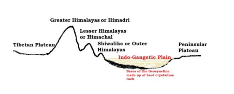
Division of the Himalayas
Shiwaliks or outer Himalayas
Lesser or Middle Himalayas
The Greater Himalayas
The Trans-Himalayas – Tibetan Himalayas
The Eastern Hills – Purvancha.
Himalayan Ranges
• Series of several parallel or converging ranges.
• The ranges are separated by deep valleys creating a highly dissected topography [(of a plateau or upland) divided by a number of deep valleys].
• The southern slopes have steep gradients and northern slopes have comparatively gentler slopes.
• Most of the Himalayan ranges fall in India, Nepal and Bhutan. The northern slopes are partly situated in Tibet (trans-Himalayas) while the western extremity lies in Pakistan, Afghanistan and Central Asia.
• Himalayas between Tibet and Ganga Plain is a succession of three parallel ranges.
Shiwalik Range
• Also known as Outer Himalayas
• Located in between the Great Plains and Lesser Himalayas
• The altitude varies from 600 to 1500 metres
• Runs for a distance of 2,400 km from the Potwar Plateau to the Brahmaputra valley
• The southern slopes are steep while the northern slopes are gentle
• The width of the Shiwaliks varies from 50 km in Himachal Pradesh to less than 15 km in Arunachal Pradesh.
• They are almost unbroken chain of low hills except for a gap of 80-90 km which is occupied by the valley of the Tista River and Raidak River.
• Shiwalik range from North-East India up to Nepal is covered with thick forests but the forest cover decreases westwards from Nepal (The quantum of rainfall decreases from to west in Shiwaliks and Ganga Plains).
• The southern slopes of Shiwalik range in Punjab and Himachal Pradesh are almost devoid of forest cover. These slopes are highly dissected by seasonal streams called Chos.
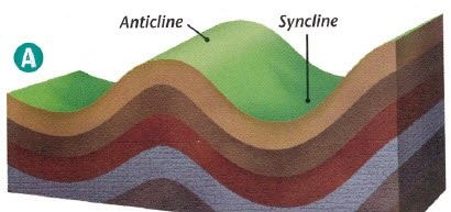
• Valleys are part of synclines and hills are part of anticlines or antisynclines.
Formation
• Shiwaliks were formed last of all the ranges (2-20 million years ago).
• The Shiwaliks are consolidated sands, gravels and conglomerate deposits [Alluvial fans] which were brought by the rivers flowing from the higher ranges.
• These deposits were folded and hardened due to compression offered by the northward movement of Indian plate.
• The Shiwaliks are known by different names in different areas
Region Name of Shiwaliks
Jammu Region Jammu Hills
Dafla, Miri, Abor and Mishmi Hills Arunachal Pradesh
The Dhang Range, Dundwa Range Uttarakhand
Churia Ghat Hills Nepal
Duns (Duars)
• Shiwaliks were formed by the accumulation of conglomerates (sand, stone, silt, gravel, debris etc.).
• These conglomerates, in the initial stages of deposition, obstructed the courses of the rivers draining from the higher reaches of the Himalayas and formed temporary lakes.
• With passage of time, these temporary lakes accumulated more and more conglomerates. The conglomerates were well settled at the bottom of the lakes.
• When the rivers were able to cut their courses through the lakes filled with conglomerate deposits, the lakes were drained away leaving behind plains called ‘duns’ or ‘doons’ in the west and ‘duars’ in the east.
• Dehra Dun in Uttarakhand is the best example [75 km long and 15-20 km wide]
• Kotah, Patli Kothri, Chumbi, Kyarda, Chaukhamba, Udhampur and Kotli are other important duns.
Middle or the Lesser Himalaya
• In between the Shiwaliks in the south and the Greater Himalayas in the north
• Runs almost parallel to both the ranges
• It is also called the Himachal or Lower Himalaya
• Lower Himalayan ranges are 60-80 km wide and about 2400 km in length
• Elevations vary from 3,500 to 4,500 m above sea level
• Many peaks are more than 5,050 m above sea level and are snow covered throughout the year.
• Lower Himalayas have steep, bare southern slopes [steep slopes prevents soil formation] and more gentle, forest covered northern slopes.
• In Uttarakhand, the Middle Himalayas are marked by the Mussoorie and the Nag Tibba ranges.
• The Mahabharat Lekh, in southern Nepal is a continuation of the Mussoorie Range
• East of the Kosi River, the Sapt Kosi, Sikkim, Bhutan, Miri, Abor and Mishmi hills represent the lower Himalayas.
• Majority of the Himalayan hill resorts like Shimla, Mussoorie, Ranikhet, Nainital, Almora and Darjeeling, etc. are located here.
Important ranges of Lesser Himalayas
The Pir Panjal Range Jammu and Kashmir (They are to the south of Kashmir Valley)
The Dhaula Dhar Range Himachal Pradesh
The Mussoorie Range and The Nag Tiba Range Uttarakhand
Mahabharat Lekh Nepal
The Pir Panjal range
• The Pir Panjal range in Kashmir is the longest and the most important range
• It extends from the Jhelum river to the upper Beas river for over 300 km
• It rises to 5,000 metres and contains mostly volcanic rocks
Passes in Pir Panjal:
• Pir Panjal Pass (3,480 m), the Bidil (4,270 m), Golabghar Pass (3,812 m) and Banihal Pass (2,835 m).
• The Banihal Pass is used by the Jammu-Srinagar highway and Jammu-Baramula railway.
• The Kishanganga, the Jhelum and the Chenab cut through the range.
• Southeast of the Ravi, the Pir Panjal continues as Dhaola Dhar range, passing through Dalhousie, Dharmshala, and Shimla.
Important Valleys
• Between the Pir Panjal and the Zaskar Range of the main Himalayas, lies the valley of Kashmir. (average elevation is 1,585 m above mean sea level)
• The synclinal basin of the valley is floored with alluvial, lacustrine [lake deposits], fluvial [river action] and glacial deposits
• Jhelum river meanders through these deposits and cuts a deep gorge in Pir Panjal through which it drains. (Kashmir is like a basin with very few outlets)
• In Himachal Pradesh there is Kangra Valley. It is a strike valley and extends from the foot of the Dhaola Dhar Range to the south of Beas.
• On the other hand, the Kulu Valley in the upper course of the Ravi is transverse valley.
The Great Himalayas
• Also known as Inner Himalaya, Central Himalaya or Himadri
• Average elevation of 6,100 m above sea level and an average width of about 25 km.
• It is mainly formed of the central crystallines (granites and gneisses) overlain by metamorphosed sediments [limestone].
• The folds in this range are asymmetrical with steep south slope and gentle north slope giving ‘hog back (a long, steep hill or mountain ridge)’ topography.
• This mountain arc convexes to the south just like the other two.
• Terminates abruptly at the syntaxial bends: one in the Nanga Parbat in north-west and the other in the Namcha Barwa in the north-east
• This mountain range boasts of the tallest peaks of the world, most of which remain under perpetual snow.

Regional name of Mount Everest
Sagarmatha (The Goddess of the Sky) Nepal
Chomlungma (Mother of the World) China (Tibet)
Mount Everest was first located by George Everest, the then Surveyor General of India in 1841 and in 1852 it was established as the highest peak of the world by the Great Trigonometrical Survey of India.
The Trans Himalayas
• The Himalayan ranges immediately north of the Great Himalayan range.
• Also called the Tibetan Himalaya because most of it lies in Tibet.
• The Zaskar, the Ladakh, the Kailas and the Karakoram are the main ranges.
• It stretches for a distance of about 1,000 km in east-west direction.
• Average elevation is 3000 m above mean sea level.
• The average width of this region is 40 km at the extremities and about 225 km in the central part.
• The Nanga Parbat (8126 m) is an important range which is in The Zaskar Range.
• North of the Zaskar Range and running parallel to it is the Ladakh Range. Only a few peaks of this range attain heights of over 6000 metres.
• The Kailas Range (Gangdise in Chinese) in western Tibet is an offshoot of the Ladakh Range. The highest peak is Mount Kailas (6714 m). River Indus originates from the northern slopes of the Kailas range.
• The northern most range of the Trans-Himalayan Ranges in India is the Great Karakoram Range also known as the Krishnagiri range.
• Karakoram Range extends eastwards from the Pamir for about 800 km. It is a range with lofty peaks [elevation 5,500 m and above]. It is the abode of some of the greatest glaciers of the world outside the polar regions.
• Some of the peaks are more than 8,000 metre above sea level. K2 (8,611 m)[Godwin Austen or Qogir] is the second highest peak in the world and the highest peak in the Indian Union.
• The Ladakh Plateau lies to the north-east of the Karakoram Range. It has been dissected into a number of plains and mountains [Soda Plains, Aksai Chin, Lingzi Tang, Depsang Plains and Chang Chenmo]
Purvanchal or Eastern Hills
• Eastern Hills or Purvanchal are the southward extension of Himalayas running along the north-eastern edge of India.
• At the Dihang gorge, the Himalayas take a sudden southward bend and form a series of comparatively low hills which are collectively called as the Purvanchal.
• Purvanchal hills are convex to the west.
• They run along the India-Myanmar Border extending from Arunachal Pradesh in the north to Mizoram in the south.

• Patkai Bum hills are made up of strong sandstone; elevation varying from 2,000 m to 3,000 m; merges into Naga Hills where Saramati (3,826 m) is the highest peak.
• Patkai Bum and Naga Hills form the watershed between India and Myanmar.
• South of Naga Hills are the Manipur hills which are generally less than 2,500 metres in elevation.
• The Barail range separates Naga Hills from Manipur Hills.
• Further south the Barail Range swings to west into Jaintia, Khasi and Garo hills which are an eastward continuation of the Indian peninsular block. They are separated from the main block by Ganga and Brahmaputra rivers.
• South of the Manipur Hills are the Mizo Hills (previously known as the Lushai hills) which have an elevation of less than 1,500 metres. The highest point is the Blue Mountain (2,157 m) in the south.
Syntaxial Bends of the Himalayas
• Himalayas extend in the east-west direction from the Indus gorge in the west to the Brahmaputra gorge in the east.
• Himalayan ranges take sharp southward bends at these gorges. These bends are called syntaxial bends of the Himalayas.
• The western syntaxial bend occurs near the Nanga Parbat where the Indus river has cut a deep gorge.
• The eastern syntaxial bend occurs near the Namche Barwa.
LONGITUDIONAL DIVISION OF THE HIMALAYAS
Punjab Himalayas
• Between the Indus and the Satluj rivers [560 km long]
• All the major rivers of Indus river system flow through Punjab Himalayas.
• A large portion of Punjab Himalayas is in Jammu and Kashmir and Himachal Pradesh. Hence they are also called the Kashmir and Himachal Himalaya.
• Karakoram, Ladakh, Pir Panjal, Zaskar and Dhaola Dhar are the major ranges in this section.
• The general elevation falls westwards.
Assam Himalayas
• Spreads over Sikkim, Assam and Arunachal Pradesh.
• Elevation here is much lesser than that of the Nepal Himalayas.
• The southern slopes are very steep but the northern slopes are gentle.
• The Lesser Himalayas are very narrow and are very close to the Great Himalayas.
Western Himalayas
• Between the Indus in the west and the Kali river in the east (880 km).
• Spread across three states of Jammu and Kashmir, Himachal Pradesh and Uttarakhand.
• It encompasses three physiographic provinces namely Kashmir Himalaya, Himachal Himalaya and Kumaon Himalaya (Uttarakhand Himalayas).
• The Ladakh plateau and the Kashmir valley are two important areas of the Kashmir Himalayan region.
• In Himachal Himalayas, The Greater Himalaya is represented by the Zaskar range, lesser Himalaya by Pir Panjal and Dhauladhar ranges and the Outer Himalaya by the Shiwalik range.
• The southern slopes are rugged, steep and forested while the northern slopes are bare, gentle and show plains with lakes.
• The Kumaon Himalayas lie in Uttarakhand and extend from the Satluj to the Kali river.
• The Lesser Himalayas in Kumaon Himalaya is represented by the Mussoorie and Nag Tiba ranges.
• The Shiwalik in this region runs south of the Mussoori range between the Ganga and the Yamuna rivers.
• The flat valleys between the Lesser Himalaya and the Shiwalik range are called ‘ doons’ or ‘Duns’ of which Dehra Dun is the most famous.
Central Himalayas
• 800 km between river Kali in the west and river Tista in the east
• The Great Himalaya range attains maximum height in this portion.
• Some of the world famous peaks Mt. Everest, Kanchenjunga, Makalu, Annapurna, Gosainthan and Dhaulagiri are located here.
• The Lesser Himalaya is known as Mahabharat Lekh in this region.
• The range is crossed by rivers like Ghaghara, Gandak, Kosi, etc.
• In between the Great and the Lesser Himalayas, there are Kathmandu and Pokhra lacustrine valleys (previously, they were lakes).
• The Shiwalik range come very close to the lesser Himalaya towards the east and is almost non-existent beyond Narayani (Gandak).
Eastern Himalayas
• This part of the Himalayas lies between the Teesta river in the west and the Brahmaputra river in the east and stretches for a distance of about 720 km.
• Also known as the Assam Himalayas, the Eastern Himalayas occupy mainly the areas of Arunachal Pradesh and Bhutan.
• The Assam Himalayas show a marked dominance of fluvial erosion due to heavy rainfall.
• The Himalayas take a sudden southward turn after the Dihang gorge and the hill ranges running in more or less north-south direction along India’s border with Myanmar are collectively known as the Purvanchal.
• These are known by various local names such as Patkai Bum, Naga hills, Kohima hills, Manipur hills, Mizo hills (previously known as the Lushai hills), Tripura hills and Barail range.
Purvanchal – Eastern Himalayas
• The extension of the Purvanchal Himalaya continues southwards upto Andaman and Nicobar Islands through the Myanmar range (Arakan Yoma) and even upto the Indonesian archipelago.
• In the eastern section the Himalayas rise abruptly from the plains of Bengal and Oudh and suddenly attain great elevations within a short distance from the foot of the mountains. Thus the peaks of Kanchenjunga and Everest are only a few kilometres from the plains and are clearly visible from there.
• In contrast, the western Himalayas rise gradually from the plains through a series of ranges. Their peaks of perpetual snow are 150 to 200 km away from the plain areas.
MAJOR PASSES OF THE HIMALAYAS
• Most of the passes remain closed in winter (Nov – Apr) due to heavy snow fall.
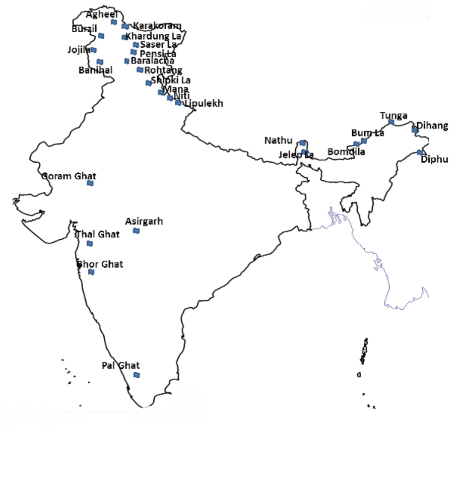
Passes of the Western Himalayas
Jammu and Kashmir
Mintaka Pass
• Kashmir and China
• Trijunction of India-China and Afghanistan border
Khunjerab Pass
• Kashmir and China on the Indo-China border
Aghil Pass
• Ladakh region of India with the Xinjiang (Sinkiang) Province of China
• altitude of 5000 m above sea level
• north of K2 Peak (the highest peak in India and the second highest peak in the world)
Banihal Pass
• Jammu and Srinigar
• altitude of 2832 m
• across the Pir-Panjal Range
• remains snow covered during winter season
• Road from Jammu to Srinagar transverses Banihal Pass until 1956 when Jawahar Tunnel was constructed under the pass. The road now passes through the tunnel and the Banihal Pass is no longer used for road transport.
• Another 11 km long tunnel provides railway link between Banihal and Qazigund. It was open to railway transport in July, 2013
Chang-La
• Ladakh with Tibet
• altitude of 5360 m
• Has a temple dedicated to Chang-La Baba after whom the pass has been named
Khardung La
• near Leh in the Ladakh range
• altitude of 5602 m
• The world’s highest motorable road passes through this pass
• remains closed in winter due to heavy snowfall
Lanak La
• India and China (in the Akasai-Chin area of Jammu and Kashmir)
• this pass provides passage between Ladakh and Lhasa. A road to connect Xinjiang with Tibet has been constructed by the Chinese
Pir-Panjal pass
• across the Pir Panjal range
• provides the shortest and the easiest metal road between Jammu and Kashmir Valley. But this route had to be closed down as a result of partition of the subcontinent
Zoji La
• important road link between Srinagar and Kargil, Leh
• Road passing through this pass has been designated at the National Highway (NH-1D)
• Border Road Organisation (BRO) is responsible for maintaining the road and cleaning it off snow during winter. In spite of all these efforts, the road through this pass remains closed from December to mid-May
Himachal Pradesh
Bara Lacha La
• Himachal Pradesh and Jammu and Kashmir
• Elevation of 4,890 m
• National highway connecting Mandi in Himachal Pradesh with Leh in Jammu and Kashmir passes through this pass
Debsa Pass
• link between Kullu and Spiti districts
• elevation of 5270 m above sea level
• It offers a much easier and shorter alternative route to traditional Pin-Parbati Pass route between Kullu and Spiti
Rohtang Pass
• road link between Kullu, Lahul and Spiti Valleys
• Elevation of 3979 m
• Border Road Organisation (BRO) is responsible for constructing and maintaining roads in this area
• Rohtang pass is a great tourist attraction and traffic jams are very common because this route is widely used by military, public and private vehicles.
Shipki La
• Himachal Pradesh and Tibet
• Elevation: 6000 m
• Satluj river enters India from Tibet through this pass
Uttarakhand
Lipu Lekh
• trijunction of Uttarakhand, Tibet and Nepal
• Used by pilgrims to Kailash-Mansarovar Yatra
Mana Pass
• Uttarakhand with Tibet
• elevation of 5610m
• Situated a little north of the holy place of Badrinath
Mangsha Dhura
• Uttarakhand with Tibet
• Used by pilgrims going to Kailash-Mansarovar
Niti Pass
• Uttarakhand with Tibet
Muling La
• Uttarakhand and Tibet
• situated in the north of Gangotri
• at an elevation of 5669 m in the Great Himalayas
Passes of the Eastern Himalayas
Sikkim
Nathu La
• Sikkim with Tibet
• altitude of 4310 m
• it forms part of an offshoot of the ancient Silk Route
• an important trade route between India and China
• It was closed after the Chinese aggression on India in 1962 but was reopened in 2006 as the governments of the two countries decided to enhance their trade through land routes
Jelep La
• Sikkim-Bhutan border
• altitude of 4538 m
• passes through Chumbi Valley
• important link between Sikkim and Lhasa
Arunachal Pradesh
Bomdila
• Arunachal Pradesh with Bhutan
• Situated at an altitude of 4331 m near the western boundary of Arunachal Pradesh in the Greater Himalayas
• connects Arunachal Pradesh with Lhasa
Dihang Pass
• Arunachal Pradesh and Myanmar.
• elevation of more than 4000 m it provides passage
• Yonggyap Pass: Arunachal Pradesh with Tibet
Diphu Pass
• trijunction of India, China and Myanmar
• easy access between Arunachal Pradesh and Mandalay in Myanmar. It is an important land trade route between India and Myanmar and remains open throughout the year.
Kumjawng Pass: Arunachal Pradesh with Myanmar
Hpungan Pass: Arunachal Pradesh with Myanmar
Chankan Pass: Arunachal Pradesh with Myanmar
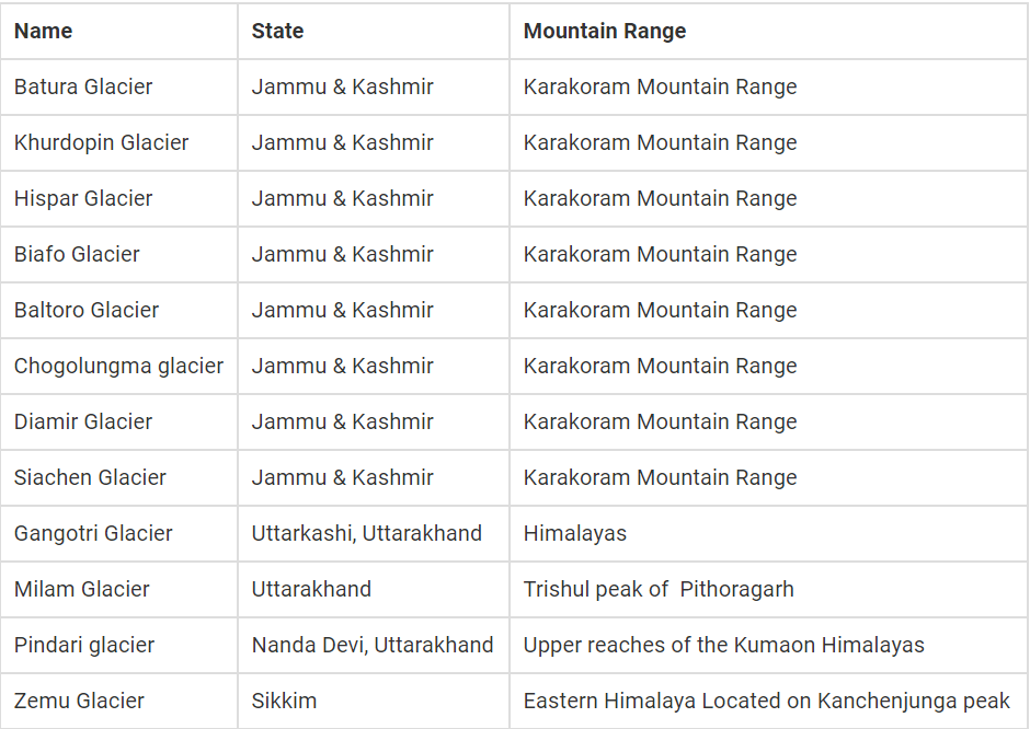
GLACIERS IN HIMALAYAS
• There are about 15,000 glaciers in the Himalayas.
• Total area of Himalayas is about five lakh square kilometres (Area of India is nearly 32 lakh sq km). About 33,000 sq km area is covered by snow.
• The snow line (the lowest level of perpetual snow) varies in different parts of the Himalayas depending upon latitude, amount of precipitation and local topography.
INDO – GANGETIC – BRAHMAPUTRA PLAIN
Formation of Indo – Gangetic – Brahmaputra trough
• The formation of Indo-Gangetic plain is closely related to the formation of Himalayas.
• The rivers which were previously flowing into Tethys sea (Before Indian Plate collided with Eurasian Plate – continental drift, plate tectonics) deposited huge amount of sediments in the Tethys Geosyncline.
• Himalayas are formed out of these sediments which were uplifted, folded and compressed due to northern movement of Indian Plate.
• Northern movement of Indian Plate also created a trough to the south of Himalayas.
Depositional Activity
• During the initial stages of upliftment of sediments, the already existing rivers changed their course several times and they were rejuvenated each time (perpetual youth stage of rivers {Fluvial Landforms}).
• The rejuvenation is associated with intense headward and vertical downcutting of the soft strata overlying the harder rock stratum.
• Headward erosion and vertical erosion of the river valley in the initial stages, lateral erosion in later stages contributed huge amount of conglomerates (detritus)(rock debris, silt, clay etc.) which were carried downslope.
• [Head ward erosion == Erosion at the origin of a stream channel, which causes the origin to move back away from the direction of the stream flow, and so causes the stream channel to lengthen]
• These conglomerates were deposited in the depression (Indo-Gangetic Trough or Indo-Gangetic syncline) (the base of the geosyncline is a hard crystalline rock) between peninsular India and the convergent boundary (the region of present day Himalayas).
New rivers and more alluvium
• The raising of Himalayas and subsequent formation of glaciers gave rise to many new rivers. These rivers along with glacial erosion, supplied more alluvium which intensified the filling of the depression.
• With the accumulation of more and more sediments (conglomerates), the Tethys Sea started receding.
• With passage of the time, the depression was completely filled with alluvium, gravel, rock debris (conglomerates) and the Tethys completely disappeared leaving behind a monotonous aggradational plain.
• [monotonous == featureless topography; aggradational plain == plain formed due to depositional activity. Indo-Gangetic plain is a monotonous aggradational plain formed due to fluvial depositions].
• Upper peninsular rivers have also contributed to the formation of plains, but to a very small extent.
• During the recent times (since few million years), depositional work of three major river systems viz., the Indus, the Ganga and the Brahmaputra have become predominant.
• Hence this arcuate (curved) plain is also known as Indo-Gangetic-Brahmaputra Plain.
Features of Indo – Gangetic – Brahmaputra Plain
• Indo-Gangetic-Brahmaputra Plain is the largest alluvial tract of the world.
• It stretches for about 3,200 km from the mouth of the Indus to the mouth of the Ganga. Indian sector of the plain accounts for 2,400 km.
• The northern boundary is well marked by the Shiwaliks and the southern boundary is a wavy irregular line along the northern edge of the Peninsular India.
• The western boarder is marked by Sulaiman and Kirthar ranges. On the eastern side, the plains are bordered by Purvanchal hills.
• The width of the plain varies from region to region. It is widest in the west where it stretches for about 500 km. Its width decreases in the east.
• The thickness of the alluvium deposits also vary from place to place. The maximum depth of the alluvium up to the basement rocks is about 6,100 m (not uniform and varies greatly from place to place).
• The cones or alluvial fans of Kosi in the north and those of Son in the south exhibit greater alluvial thickness while the intra-cone areas have relatively shallower deposits.
• Extreme horizontality of this monotonous plain is its chief characteristic.
• Its average elevation is about 200 m above mean sea level, highest elevation being 291 m above mean sea level near Ambala (This elevation forms the drainage divide or watershed between Indus system and Ganga system).
• Its average gradient from Saharanpur to Kolkata is only 20 cm per km and it decreases to 15 cm per km from Varanasi to the Ganga delta.
Geomorphological features of Indo – Gangetic – Brahmaputra Plain
Bhabar
• It is a narrow, porous, northern most stretch of Indo-Gangetic plain.
• It is about 8-16 km wide running in east-west direction along the foothills (alluvial fans) of the Shiwaliks.
• They show a remarkable continuity from the Indus to the Teesta river.
• Rivers descending from the Himalayas deposit their load along the foothills in the form of alluvial fans.
• These alluvial fans have merged together to build up the bhabar belt.
• The porosity of bhabar is the most unique feature.
• The porosity is due to deposition of huge number of pebbles and rock debris across the alluvial fans.
• The streams disappear once they reach the bhabar region because of this porosity.
• Therefore, the area is marked by dry river courses except in the rainy season.
• The Bhabar belt is comparatively narrow in the east and extensive in the western and north-western hilly region.
• The area is not suitable for agriculture and only big trees with large roots thrive in this belt.
Terai
• Terai is an ill-drained, damp (marshy) and thickly forested narrow tract to the south of Bhabar running parallel to it.
• The Terai is about15-30 km wide.
• The underground streams of the Bhabar belt re-emerge in this belt.
• This thickly forested region provides shelter to a variety of wild life. [Jim Corbett National Park in Uttarakhand and Kaziranga National Park in Assam lie in Terai region]
• The Terai is more marked in the eastern part than in the west because the eastern parts receive comparatively higher amount of rainfall.
• Most of the Terai land, especially in Punjab, Uttar Pradesh and Uttarakhand, has been turned into agricultural land which gives good crops of sugarcane, rice and wheat.
Bhangar
• The Bhangar is the older alluvium along the river beds forming terraces higher than the flood plain.
• The terraces are often impregnated with calcareous concretions known as ‘Kankar’.
• ‘The Barind plains’ in the deltaic region of Bengal and the ‘bhur formations’ in the middle Ganga and Yamuna doab are regional variations of Bhangar.
• [Bhur denotes an elevated piece of land situated along the banks of the Ganga river especially in the upper Ganga-Yamuna Doab. This has been formed due to accumulation of wind-blown sands during the hot dry months of the year]
• Bhangar contains fossils of animals like rhinoceros, hippopotamus, elephants, etc.
Khadar
• The Khadar is composed of newer alluvium and forms the flood plains along the river banks.
• A new layer of alluvium is deposited by river flood almost every year.
• This makes them the most fertile soils of Ganges.
Reh or Kallar
• Reh or Kallar comprises saline efflorescences of drier areas in Haryana.
• Reh areas have spread in recent times with increase in irrigation (capillary action brings salts to the surface).
Regional Divisions of the Indo-Gangetic-Brahmaputra Plains
- Sindh Plain
- Rajasthan Plain.
- Punjab Plain.
- Ganga Plain.
- Brahmaputra Plain.
- Ganga – Brahmaputra Delta
Sindh Plain [Pakistan]
• Mainly formed of Bhangar Plains
• Dhors: Long narrow depressions which are the remnants of the course of former rivers.
• Dhands: Alkaline lakes on some dhors
Rajasthan Plain
• Occupied by Thar or the Great Indian Desert
• This plain is an undulating plain [wave like] whose average elevation is about 325 m above mean sea level.
• The desert region is called Marusthali and forms a greater part of the Marwar plain.
• It has a few outcrops of gneisses, schists and granites which proves that geologically it is a part of the Peninsular Plateau. It is only at the surface that it looks like an aggradational plain.
• In general, the eastern part of the Marusthali is rocky while its western part is covered by shifting sand dunes locally known as
• The eastern part of the Thar Desert up to the Aravali Range is a semi-arid plain known as Rajasthan Bagar.
• It is drained by a number of short seasonal streams originating from the Aravali and supports agriculture in some patches of fertile tracts.
• Luni is an important seasonal stream which flows into Rann of Kuchchh. The tract north of the Luni is known as thali or sandy plain.
Saline Lakes
• North of the Luni, there is inland drainage having several saline lakes. They are a source of common salt and many other salts.
• Sambhar, Didwana, Degana, Kuchaman, etc. are some of the important lakes. The largest is the Sambhar lake near Jaipur.
Punjab Plain
• This plain is formed by five important rivers of Indus system.
• Punjab literally means “(The Land of) Five Waters” referring to the following rivers: the Jhelum, Chenab, Ravi, Sutlej, and Beas.
• The plain is primarily made up of ‘doabs’ —the land between two rivers.
• The depositional process by the rivers has united these doabs giving an homogenous appearance.
• The total area of this plain is about 1.75 lakh sq km.
• The average elevation of the plain is about 250 m above mean sea level.
• The eastern boundary of Punjab Haryana plain is marked by subsurface Delhi-Aravali ridge.
• The northern part of this plain [Shiwalik hills] has been intensively eroded by numerous streams called Chos. This has led to enormous gullying.
• To the south of the Satluj river there is Malwa plain of Punjab.
• The area between the Ghaggar and the Yamuna rivers lies in Haryana and often termed as ‘Haryana Tract’. It acts as water-divide between the Yamuna and the Satluj rivers.
• The only river between the Yamuna and the Satluj is the Ghaggar which is considered to be the present day Successor of the legendary Saraswati River
Ganga Plain
• This is the largest unit of the Great Plain of India stretching from Delhi to Kolkata (about 3.75 lakh sq km).
• The Ganga along with its large number of tributaries originating in the Himalayans have brought large quantities of alluvium from the mountains and deposited it here to build this extensive plain.
• The peninsular rivers such as Chambal, Betwa, Ken, Son, etc. joining the Ganga river system have also contributed to the formation of this plain.
• The general slope of the entire plain is to the east and south east.
• Rivers flow sluggishly in the lower sections of Ganges as a result of which the area is marked by local prominences such as levees, bluffs, oxbow lakes, marshes, ravines, etc.
• Almost all the rivers keep on shifting their courses making this area prone to frequent floods. The Kosi river is very notorious in this asspect. It has long been called the ‘Sorrow of Bihar’.
Regional divisions of Ganga plains
Rohilkhand plains
Avadh Plains
Mithila Plain
Magadh Plain
Ganga-Brahmaputra Delta
• This is the largest delta in the world.
• The Ganga river divides itself into several channels in the delta area. The slope of the land here is a mere 2 cm per km. Two thirds of the area is below 30 m above mean sea level. [Highly vulnerable to sea level changes]
• The seaward face of the delta is studded with a large number of estuaries, mud flats, mangrove swamps, sandbanks, islands and forelands.
• Large part of the coastal delta is covered tidal forests. These are called the Sunderbans because of the predominance of Sundri tree here.
Brahmaputra Plain
• This is also known as the Brahmaputra valley or Assam Valley or Assam Plain as most of the Brahmaputra valley is situated in Assam.
• Its western boundary is formed by the Indo-Bangladesh border as well as the boundary of the lower Ganga Plain. Its eastern boundary is formed by Purvanchal hills.
• It is an aggradational plain built up by the depositional work of the Brahmaputra and its tributaries.
• The innumerable tributaries of the Brahmaputra river coming from the north form a number of alluvial fans. Consequently, the tributaries branch out in many channels giving birth to river meandering leading to formation of bill and ox-bow lakes.
• There are large marshy tracts in this area. The alluvial fans formed by the coarse alluvial debris have led to the formation of terai or semi-terai conditions.
Significance of the Plain
• This one fourth of the land of the country hosts half of the Indian population.
• Fertile alluvial soils, flat surface, slow moving perennial rivers and favorable climate facilitate intense agricultural activity.
• The extensive use of irrigation has made Punjab, Haryana and western part of Uttar Pradesh the granary of India (Prairies are called the granaries of the world).
• The entire plain except the Thar Desert, has a close network of roads and railways which has led to large scale industrialization and urbanization.
• Cultural tourism: There are many religious places along the banks of the sacred rivers like the Ganga and the Yamuna which are very dear to Hindus. Here flourished the religions of Budha and Mahavira and the movements of Bhakti and Sufism.
PENINSULAR PLATEAU

Features of the Peninsular Plateau
• Roughly triangular in shape with its base coinciding with the southern edge of the great plain of North India. Apex of the triangular plateau is at Kanyakumari.
• It covers a total area of about 16 lakh sq km (India as a whole is 32 lakh sq km).
The average height of the plateau is 600-900 m above sea level (varies from region to region).
• Most of the peninsular rivers flow west to east indicating its general slope.
• Narmada-Tapti are the exceptions which flow from east to west in a rift (rift is caused by divergent boundary.
• The Peninsular Plateau is a one of the oldest landforms of earth.
• It is a highly stable block composed mostly of the Archaean gneisses and schists
• It has been a stable shield which has gone through little structural changes since its formation.
• Since few hundred million years, Peninsular block has been a land area and has never been submerged beneath the sea except in a few places.
• Peninsular Plateau is an aggregation of several smaller plateaus, hill ranges interspersed with river basins and valleys.
Minor Plateaus in the Peninsular Plateau
Marwar Plateau or Mewar Plateau
• It is the plateau of eastern Rajasthan. [Marwar plain is to the west of Aravalis whereas Marwar plateau is to the east].
• The average elevation is 250-500 m above sea level and it slopes down eastwards.
• It is made up of sandstone, shales and limestones of the Vindhayan period.
• The Banas river, along with its tributaries [Berach river, Khari rivers] originate in the Aravali Range and flow towards northwest into Chambal river. The erosional activity of these rives make the plateau top appear like a rolling plain.
• [Rolling Plain: ‘Rolling plains’ are not completely flat: there are slight rises and fall in the land form. Ex: Prairies of USA]
Central Highland
• Also called the Madhya Bharat Pathar or Madhya Bharat Plateau.
• It is to the east of the Marwar or Mewar Upland.
• Most of plateau comprises the basin of the Chambal river which flows in a rift valley.
• The Kali Sindh, flowing from Rana Prataph Sagar, the Banas flowing through Mewar plateau and the Parwan and the Parbati flowing from Madhya Pradesh are its main tributaries.
• It is a rolling plateau with rounded hills composed of sandstone. Thick forests grow here.
• To the north are the ravines or badlands of the Chambal river [They are typical to Chambal river basin]
Bundelkhand Upland
• Yamuna river to the north, Madhya Bharat Pathar to the west, Vindhyan Scarplands to the east and south-east and Malwa Plateau to the south
• It is the old dissected (divided by a number of deep valleys) upland of the ‘Bundelkhand gneiss’ comprising of granite and gneiss.
• Spreads over five districts of Uttar Pradesh and four districts of Madhya Pradesh.
• Average elevation of 300-600 m above sea level, this area slopes down from the Vindhyan Scarp toward the Yamuna River.
• The area is marked by a chain of hillocks (small hill) made of granite and sandstone.
• The erosional work of the rivers flowing here have converted it into an undulating (wave like surface) area and rendered it unfit for cultivation.
• The region is characterized by senile (characteristic of or caused by old age) topography.
• Streams like Betwa, Dhasan and Ken flow through the plateau.
Malwa Plateau
• The Malwa Plateau roughly forms a triangle based on the Vindhyan Hills, bounded by the Aravali Range in the west and Madhya Bharat Pathar to the north and Bundelkhand to the east.
• This plateau has two systems of drainage; one towards the Arabian Sea (The Narmada, the Tapi and the Mahi), and the other towards the Bay of Bengal (Chambal and Betwa, joining the Yamuna).
• In the north it is drained by the Chambal and many of its right bank tributaries like the Kali, the Sindh and the Parbati. It also includes the upper courses of the Sindh, the Ken and the Betwa.
• It is composed of extensive lava flow and is covered with black soils.
• The general slope is towards the north [decreases from 600 m in the south to less than 500 m in the north]
• This is a rolling plateau dissected by rivers. In the north, the plateau is marked by the Chambal ravines.
Baghelkhand
• North of the Maikal Range is the Baghelkhand.
• Made of limestones and sandstones on the west and granite in the east.
• It is bounded by the Son river on the north.
• The central part of the plateau acts as a water divide between the Son drainage system in the north and the Mahanadi river system in the south.
• The region is uneven with general elevation varying from 150 m to 1,200 m.
• The Bhander and Kaimur are located close to the trough-axis.
• The general horizontality of the strata shows that this area has not undergone any major disturbance.
Chotanagpur Plateau
• Chotanagpur plateau represents the north-eastern projection of the Indian Peninsula.
• Mostly in Jharkhand, northern part of Chhattisgarh and Purulia district of West Bengal.
• The Son river flows in the north-west of the plateau and joins the Ganga.
• The average elevation of the plateau is 700 m above sea level.
• This plateau is composed mainly of Gondwana rocks.
• The plateau is drained by numerous rivers and streams in different directions and a radial drainage pattern. {Drainage Pattern}
• Rivers like the Damodar, the Subarnrekaha, the North Koel, the South Koel and the Barkar have developed extensive drainage basins.
• The Damodar river flows through the middle of this region in a rift valley from west to east. Here are found the Gondwana coal fields which provide bulk of coal in India.
• North of the Damodar river is the Hazaribagh plateau with an average elevation of 600 m above mean sea level. This plateau has isolated hills. It looks like a peneplain due to large scale erosion.
• The Ranchi Plateau to the south of the Damodar Valley rises to about 600 m above mean sea level. Most of the surface is rolling where the city of Ranchi (661 m) is located.
• At places it is interrupted by monadnocks (an isolated hill or ridge of erosion-resistant rock rising above a peneplain. Ex: Ayers Rock in Australia) and conical hills.
• The Rajmahal Hills forming the north eastern edge of the Chotanagpur Plateau are mostly made of basalt and are covered by lava flows {Basaltic Lava}.
• They run in north-south direction and rise to average elevation of 400 m (highest mount is 567 m). These hills have been dissected into separate plateaus.
Meghalaya Plateau
• The peninsular plateau extends further east beyond the Rajmahal hills to from Meghalaya or the Shillong plateau.
• Garo-Rajmahal Gap separates this plateau from the main block.
• This gap was formed by down-faulting (normal fault: a block of earth slides downwards). It was later filled by sediments deposited by the Ganga and Brahmaputa.
• The plateau is formed by Archaean quartzites, shales and schists.
• The plateau slopes down to Brahmaputra valley in the north and the Surma and Meghna valleys in the south.
• Its western boundary more or less coincides with the Bangladesh border.
• The western, central and the eastern parts of the plateau are known as the Garo Hills (900 m), the Khasi-Jaintia Hills (1,500 m) and the Mikir Hills (700 m).
• Shillong (1,961 m) is the highest point of the plateau.
Deccan Plateau
• It covers an area of about five lakh sq km.
• It is triangular in shape and is bounded by the Satpura and the Vindhya in the north-west, the Mahadev and the Maikal in the north, the Western Ghats in the west and the Eastern Ghats in the east.
• Its average elevation is 600 m.
• It rises to 1000 m in the south but dips to 500 m in the north.
• Its general slope is from west to east which is indicated by the flow of its major rivers.
• Rivers have further subdivided this plateau into a number of smaller plateaus.
Maharashtra Plateau
• The Maharashtra Plateau lies in Maharashtra.
• It forms the northern part of the Deccan Plateau.
• Much of the region is underlain by basaltic rocks of lava origin [Most of the Deccan Traps lies in this region].
• The area looks like a rolling plain due to weathering.
• The horizontal lava sheets have led to the formation of typical Deccan Trap topography [step like].
• The broad and shallow valleys of the Godavari, the Bhima and the Krishna are flanked [bordered on the opposite sides] by flat-topped steep sided hills and ridges.
• The entire area is covered by black cotton soil known as regur.
Karnataka Plateau
• The Karnataka Plateau is also known as the Mysore plateau.
• Lies to the south of the Maharashtra plateau.
• The area looks like a rolling plateau with an average elevation of 600-900 m.
• It is highly dissected by numerous rivers rising from the Western Ghats.
• The general trend of the hills is either parallel to the Western Ghats or across it.
• The highest peak (1913 m) is at Mulangiri in Baba Budan Hills in Chikmaglur district.
• The plateau is divided into two parts called Malnad and Maidan.
• The Malnad in Kannada means hill country. It is dissected into deep valleys covered with dense forests.
• The Maidan on the other hand is formed of rolling plain with low granite hills.
• The plateau tapers between the Western Ghats and the Eastern Ghats in the south and merges with the Niligiri hills there.
Telangana plateau
• The Telangana plateau consists of Archaean gneisses.
• It’s average elevation is 500-600 m.
• The southern part is higher than its northern counterpart.
• The region is drained by three river systems, the Godavari, the Krishna and the Penneru.
• The entire plateau is divided into Ghats and the Peneplains (a vast featureless, undulating plain which the last stage of deposition process).
Chhattisgarh Plain
• The Chhattisgarh plain is the only plain worth the name in the Peninsular plateau.
• It is a saucer shaped depression drained by the upper Mahanadi.
• The whole basin lies between the Maikala Range and the Odisha hills.
• The region was once ruled by Haithaivanshi Rajputs from whose thirty six forts (Chhattisgarh) it derives its name.
• The basin is laid with nearly horizontal beds of limestone and shales.
• The general elevation of the plain ranges from 250 m in the east to 330 m in the west.
HILL RANGES OF THE PENINSULAR PLATEAU
• Most of the hills in the peninsular region are of the relict type (residual hills).
• They are the remnants of the hills and horsts formed many million years ago (horst: uplifted block; graben: subsided block).
• The plateaus of the Peninsular region are separated from one another by these hill ranges and various river valleys.
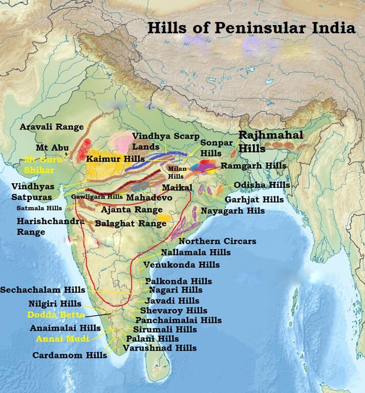
Aravali Range
• They are aligned in north-east to south-west direction.
• They run for about 800 km between Delhi and Palanpur in Gujarat.
• They are one of the oldest (very old) fold mountains of the world and the oldest in India.
• After its formation in Archaean Era (several 100 million years ago), its summits were nourishing glaciers and several summits were probably higher than the present day Himalayas.
• Now they are relict (remnants after severe weathering and erosion since millions of years) of the world’s oldest mountain formed as a result of folding (Archaean Era).
• They continue up to Haridwar buried under the alluvium of Ganga Plains.
• The range is conspicuous in Rajasthan (continuous range south of Ajmer where it rises to 900 m.) but becomes less distinct in Haryana and Delhi (characterized by a chain of detached and discontinuous ridges beyond Ajmer).
• According to some geographers, one Branch of the Aravalis extends to the Lakshadweep Archipelago through the Gulf of Khambhat and the other into Andhra Pradesh and Karnataka.
• It’s general elevation is only 400-600 m, with few hills well above 1,000 m.
• At the south-west extremity the range rises to over 1,000 m. Here Mt. Abu (1,158 m), a small hilly block, is separated from the main range by the valley of the Banas. Guru Shikhar (1,722 m), the highest peak, is situated in Mt. Abu.
• Pipli Ghat, Dewair and Desuri passes allow movement by roads and railways.
Vindhyan Range
• The Vindhyan Range, overlooking (have a view of from above) the Narmada valley, rises as an escarpment (a long, steep slope at the edge of a plateau or separating areas of land at different heights) flanking (neighbouring on one side) the northern edge of the Narmada-Son Trough (the rift through which the Narmada river flows)(trough is opposite of ridge. It is a narrow depression).
• It runs more or less parallel to the Narmada Valley in an east-west direction from Jobat in Gujarat to Sasaram in Bihar for a distance of over 1,200 km.
• The general elevation of the Vindhyan Range is 300 to 650 m.
• Most parts of the Vindhayan Range are composed of horizontally bedded sedimentary rocks of ancient age. {Rock System}
• The Vindhyas are continued eastwards as the Bhander and Kaimur hills.
• This range acts as a watershed between the Ganga system and the river systems of south India.
• The rivers Chambal, Betwa and Ken rise within 30 km of the Narmada.
Satpura Range
• Satpura range is a series of seven mountains (‘Sat’ = seven and ‘pura’ = mountains)
• It runs in an east-west direction south of the Vindhyas and in between the Narmada and the Tapi, roughly parallel to these rivers.
• It stretches for a distance of about 900 km.
• Parts of the Satpuras have been folded and upheaved. They are regarded as structural uplift or ‘horst’.
• Dhupgarh (1,350 m) near Pachmarhi on Mahadev Hills is the highest peak.
• Amarkantak (1,127 m) is another important peak.
Western Ghats (or Sahyadris)
• They form the western edge of the Deccan tableland.
• Run from the Tapi valley (21° N latitude) to a little north of Kanyakumari (11° N latitude) for a distance of 1,600 km.
• The Western Ghats are steep-sided, terraced, flat-topped hills presenting a stepped topography facing the Arabian Sea coast.
• This is due to the horizontally bedded lavas, which on weathering, have given a characteristic ‘landing stair aspect’ to the relief of this mountain chain.
• The Western Ghats abruptly rise as a sheer wall to an average elevation of 1,000 m from the Western Coastal Plain.
• But they slope gently on their eastern flank and hardly appear to be a mountain when viewed from the Deccan tableland.
• South of Malabar, the Nilgiris, Anamalai, etc. present quite different landscape due to the difference in geological structure.
The northern section
• The northern section of the Ghats from Tapi valley to a little north of Goa is made of horizontal sheets of Deccan lavas (Deccan Traps).
• The average height of this section of the Ghats is 1,200 m above mean sea level, but some peaks attain more heights.
• Kalasubai (1,646 m) near Igatpuri, Salher (1,567 m) about 90 km north of Nashik, Mahabaleshwar (1,438 m) and Harishchandragarh (1,424 m) are important peaks.
• Thal ghat and Bhor ghat are important passes which provide passage by road and rail between the Konkan Plains in the west and the Deccan Plateau in the east.
[Konkan coast == Maharashtra coast and Goa coast; Malabar Coast == Kerala and Karnataka coast]The Middle Sahyadri
• The Middle Sahyadri runs from 16°N latitude upto Nilgiri hills.
• This part is made of granites and gneisses.
• This area is covered with dense forests.
• The western scarp is considerably dissected by headward erosion of the west flowing streams.
• The average height is 1200 m but many peaks exceed 1500 m.
• The Vavul Mala (2,339 m), the Kudremukh (1,892 m) and Pashpagiri (1,714 m) are important peaks.
• The Nilgiri Hills which join the Sahyadris near the trijunction of Karnataka, Kerala and TN, rise abruptly to over 2,000 m.
• They mark the junction of the Western Ghats with Eastern Ghats.
• Doda Betta (2,637 m) and Makurti (2,554 m) are important peaks of this area.
The southern section
• The southern part of the Western Ghats is separated from the main Sahyadri range by Pal ghat Gap [Palakkad Gap].
• The high ranges terminate abruptly on either side of this gap.
• Pal ghat Gap it is a rift valley. This gap is used by a number of roads and railway lines to connect the plains of Tamil Nadu with the coastal plain of Kerala.
• It is through this gap that moist-bearing clouds of the south-west monsoon can penetrate some distance inland, bringing rain to Mysore region.
• South of the Palghat Gap there is an intricate system of steep and rugged slopes on both the eastern and western sides of the Ghats.
• Anai Mudi (2,695 m) is the highest peak in the whole of southern India.
• Three ranges radiate in different directions from Anai Mudi. These ranges are the Anaimalai (1800-2000 m) to the north, the Palani (900-1,200 m) to the north-east and the Cardamom Hills or the Ealaimalai to the south.
Eastern Ghats
• Eastern Ghats run almost parallel to the east coast of India leaving broad plains between their base and the coast.
• It is a chain of highly broken and detached hills starting from the Mahanadi in Odisha to the Vagai in Tamil Nadu. They almost disappear between the Godavari and the Krishna.
• They neither have structural unity nor physiographic continuity. Therefore these hill groups are generally treated as independent units.
• It is only in the northern part, between the Mahanadi and the Godavari that the Eastern Ghats exhibit true mountain character. This part comprises the Maliya and the Madugula Konda ranges.
• The peaks and ridges of the Maliya range have a general elevation of 900-1,200 m and Mahendra Giri (1,501 m) is the tallest peak here.
• The Madugula Konda range has higher elevations ranging from 1,100 m and 1,400 m with several peaks exceeding 1,600 m. Jindhagada Peak (1690 m) in Araku Valley Arma Konda (1,680 m), Gali Konda (1,643 m) and Sinkram Gutta (1,620 m) are important peaks.
• Between the Godavari and the Krishna rivers, the Eastern Ghats lose their hilly character and are occupied by Gondwana formations (KG Basin is here).
• The Eastern Ghats reappear as more or less a continuous hill range in Cuddapah and Kurnool districts of Andhra Pradesh where they are called as Nallamalai Range with general elevation of 600-850 m.
• The southern part of this range is called the Palkodna range.
• To the south, the hills and plateaus attain very low altitudes; only Javadi Hills and the Shevroy-Kalrayan Hills form two distinct features of 1,000 m elevation.
• The Biligiri Rangan Hills in Karnataka (at its border with Tamil Nadu) attain a height of 1,279 m.
• Further south, the Eastern Ghats merge with the Western Ghats.
Significance of the Peninsular Plateau
• There are huge deposits of iron, manganese, copper, bauxite, chromium, mica, gold, etc.
• 98 per cent of the Gondwana coal deposits of India are found in the Peninsular Plateau.
• Besides there are large reserves of slate, shale, sandstones, marbles, etc.
• A large part of north-west plateau is covered with fertile black lava soil which is extremely useful for growing cotton.
• Some hilly regions in south India are suitable for the cultivation of plantation crops like tea, coffee, rubber, etc.
• Some low lying areas of the plateau are suitable for growing rice.
• The highlands of the plateau are covered with different types of forests which provide a large variety of forest products.
• The rivers originating in the Western Ghats offer great opportunity for developing hydroelectricity and providing irrigation facilities to the agricultural crops.
• The plateau is also known for its hill resorts such as Udagamangalam (Ooty), Panchmarhi, Kodaikanal, Mahabaleshwar, Khandala, Matheron etc.