CLIMATIC REGIONS OF RAJASTHAN
The climate of Rajasthan state has varied contrasts. There are three main approaches to climatic regions of Rajasthan:
• Climatic regions of Rajasthan based on Rainfall Intensity.
• Koeppen’s classification of climatic regions of Rajasthan.
• Thornthwaite’s classification of climatic regions of Rajasthan.
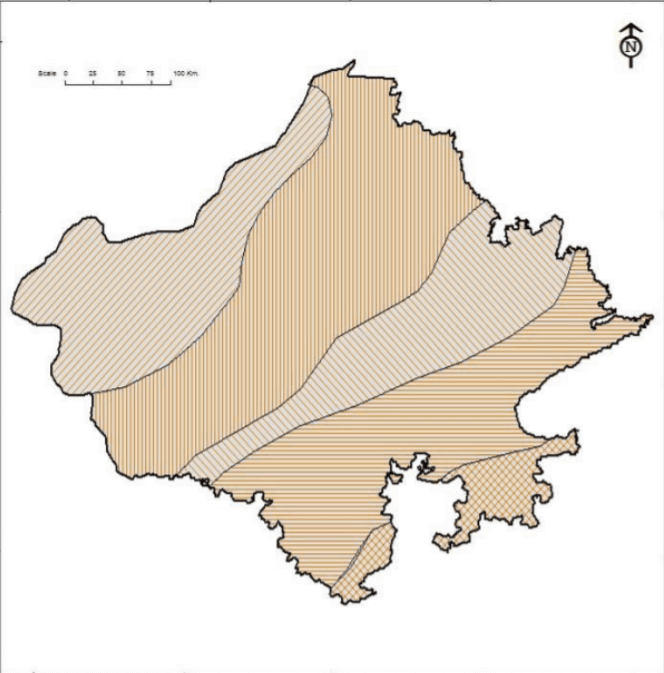
Climatic Regions of Rajasthan based on Rainfall Intensity
The distribution of climatic regions of Rajasthan on the basis of rainfall and temperature variations includes following divisions:
Arid Region:
• The Arid region includes Jaisalmer district, northern parts of Barmer, western of the Phalodi Tehsil of Jodhpur, western parts of Bikaner and southern parts of Ganganagar district.
• Climate of the region is very severe and arid.
• Rainfall less than 10 cm in extreme west parts of regions and rest areas record less than 20 cm rainfall.
• The average temperature during summer is recorded more than 34 °C and during winters it ranges in between 10 °C to 14 °C.
Semi-arid Region:
• The average temperature during winter season ranges between 10 °C and 17 °C and the summer season temperature range 32 °C to 36 °C.
• As the region has erratic as well as torrential rainfall it brings floods too each time.
• Rainfall ranges 20 to 40 cm.
• The winter season is very short and arid in the northern parts of this region.
• This region comprises the western parts of Ganganagar, Hanumangarh, Jodhpur and Barmer districts.
Sub-humid Region:
• In the semi arid humid region, rainfall is meagre and the amount of rainfall is limited to a few monsoon months only.
• The rainfall is between 40 to 60 cm and the average temperature during summer season ranges from 28 °C to 34 °C whereas it is recorded 12 °C in northern parts and 18 °C in the southern parts.
• Alwar, Jaipur, Dausa and Ajmer, eastern parts of Jhunjhunu, Sikar, Pali and Jalore districts, north-western parts of Tonk, Bhilwara and Sirohi districts are included in this category.
• This region has steppe type of vegetation.
Humid Region:
• This region receives winter rainfall associated with cyclones along with monsoon season rainfall which varies from 60 to 80 cm.
• Deciduous trees dominate the region.
• Humid region is found at the districts of Bharatpur, Dholpur, Sawai Madhopur, Bundi, Kota, Barmer and Rajsamand and the north-eastern parts of Udaipur.
Very Humid Region:
• Very Humid Region includes south-east Kota, Baran, Jhalawar, Banswara, south-west Udaipur and adjacent areas of Mt. Abu.
• Here, the summers are very hot and winters are cold and dry.
• Rainfall received is between 80 cm to 150 cm, which is mostly during the rainy season.
• Monsoon savanna type of vegetation is present in the region.
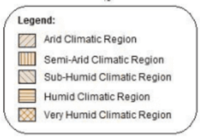
Koeppen’s Classification of climatic regions of Rajasthan
• Koeppen’s classification for the World Climatic regions is totally based on the vegetation, as the effects of temperature and rainfall are directly evident and visible it.
• Here, the three categories are associated with Tropical climates, Dry (arid and semiarid) climates and Mild Temperate climates respectively.

The classification of Rajasthan according to Koeppen is as follows:
Aw or Tropical Humid Region:
• The southern parts of Dungarpur district and Banswara come under the region.
• Here, arid tropical grasslands and Savanna like region are found along with deciduous trees of Monsoon type.
• Winter season is arid and cool whereas summers experience scorching heat.
• Rainfall also mainly occurs in summer season.
• The temperature is more than 18 °C in the coldest month records.
Bshw Climatic Region:
• This climatic region is semi-arid, where winters are dry and even in summers there is no sufficient amount of rainfall.
• Vegetation is of steppe type, characterized with thorny bushes and grasses.
• This region comprises the districts of Barmer, Jalore, Jodhpur, Nagaur, Churu, Sikar, Jhunjhunu and Hanumangarh.
Bwhw Climatic Region:
• The region has arid-hot desert climate with very scanty rainfall.
• On the contrary the process of evaporation is very active.
• Thus, these areas are known as desert region, limited to western parts of Thar Desert.
• North-western Jodhpur, Jaisalmer, western Bikaner and western parts of Ganganagar district are included in this category.
Cwg Climatic Region:
• The south-eastern areas of Aravalli are the part of the region.
• Rains are limited to few monsoon months only.
• Seasonal winds do not bring rains to this region during winters.
Thornthwaite’s classification of climatic regions of Rajasthan
• Thornthwaite took into account the amount of prepitation and evaporation along with seasonal and monthly distribution of temperature and rainfall which made it popular and widely accepted.
• Rajasthan may broadly be divided into the following four regions:
CA’w Climatic Region
• This region is characterized by wet summers and dry winters.
• Savanna and Monsoon type of vegetation are found here.
• This region includes south-eastern parts of Udaipur and districts of Banswara, Dungarpur, Kota, and Jhalawar.
DA’w Climatic Region
• The region comprises south and eastern areas of Rajasthan, covering districts of Sirohi, east Jalor, Pali, Ajmer, Chittorgarh, Bundi, Sawai Madhopur, Tonk, Bhilwara, Bharatpur, Jaipur, Dausa, Alwar, Sikar and Jhunjhunu.
• Rainfall is meager and Semi-arid vegetation is found.
• Summers are marked by High temperatures.
DB’W Climatic Region
• It includes the northern areas of Rajasthan i.e. Ganganagar, Hanumangarh, Churu and Bikaner districts.
• The region has short and dry winters whereas summers are long and associated with good rains.
• Thorny bushes and semi-arid vegetation are found here
EA’d Tropical Desert Climatic Region
• This region is also known as Marusthali and includes Barmer, Jaisalmer, western Jodhpur, south-western Bikaner district.
• The climate is very hot and arid. Rains are deficient in every season.
• Only xerophytic vegetation grows.

Average and Relative Humidity in Rajasthan
• During the monsoon months, July to September the relative humidity is generally high in the state of Rajasthan.
• The humidity is about 45% – 47% in June, which rises to a little less than 70% during August in West Rajasthan and to about 76% – 77% in East Rajasthan.
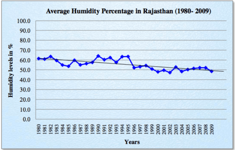
• The Graph depicts the humidity regime in the state from 1980 to 2009. The average annual humidity percentage during these 30 years was 55.4 %.
• The trend line in the figure shows a gradual decrease in humidity percentage in the state from 1980 to 2009.
• The diurnal variation in relative humidity is least during monsoon in the East Rajasthan; on the contrary it is higher in West Rajasthan.
• In the summer afternoons the relative humidity is least, i.e. about 20 to 30% in most of the state which makes the summer very dry and hot. In the winters (January and February) the diurnal variation is highest.
Air temperature and relative humidity conditions
• The pleasant winters in the state witness mean night temperatures above 4.7 °C to 10.6 °C. During summers the western Rajasthan becomes the hottest place in the country with mean maximum air temperatures varying from 38.6 °C to 42.6 °C in May.
• The recorded extreme temperatures in the state were -4.4 °C to 50.0 °C in the western Rajasthan and -2.8 °C to 47.8 °C in the eastern Rajasthan.
• The relative humidity in the arid region of Western Rajasthan is also quite high because of the unfavourable circulations of the atmosphere and low precipitation that occurs in the arid region as compared to other semi-arid and sub-humid regions.
Rainfall in Rajasthan
• The principal rainy season when the Rajasthan state receives 91% of its annual rainfall is during the South-West monsoon. The total normal annual rainfall in the state varies from 1000 cm over the South-Eastern parts to 14 cm over the extreme North-Western parts.
• The rest share of rainfall comes during the cold weather season about 2%, the summer season about 3% and during the post-monsoon season about 4% of the annual otal rainfall respectively.
• The onset of the southwest monsoon over the eastern parts of the state is witnessed almost by the last week of June which extends over the entire state by the first week of July.
• Amounting individually to about 34% of the annual rainfall each, July and August are generally the rainiest months. Around 1st September the withdrawal of the southwest monsoon begins from the northern western parts of the state and by 15th September it withdraws from the entire state. During cold weather season a small amount of rainfall i.e. 1 cm and 0.7 cm in East and West Rajasthan is received.
• This respectively is of great significance for agriculture and if occurs in association with western disturbances which move from west to east across the northern parts of the country.
• During the south-west monsoon period extending from June to September the state receives about 90% of the total rainfall.
• The cold weather period (January and February) receive the remaining portion of rainfall which occurs in association with the local convective activity.
Below is the graph for annual normal rainfall in Rajasthan:
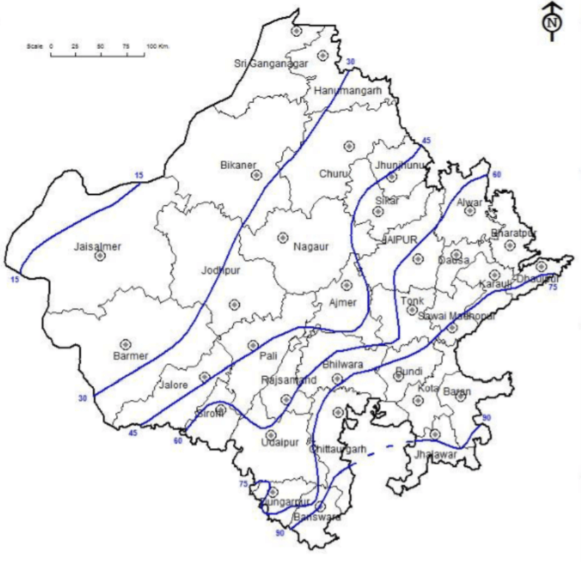
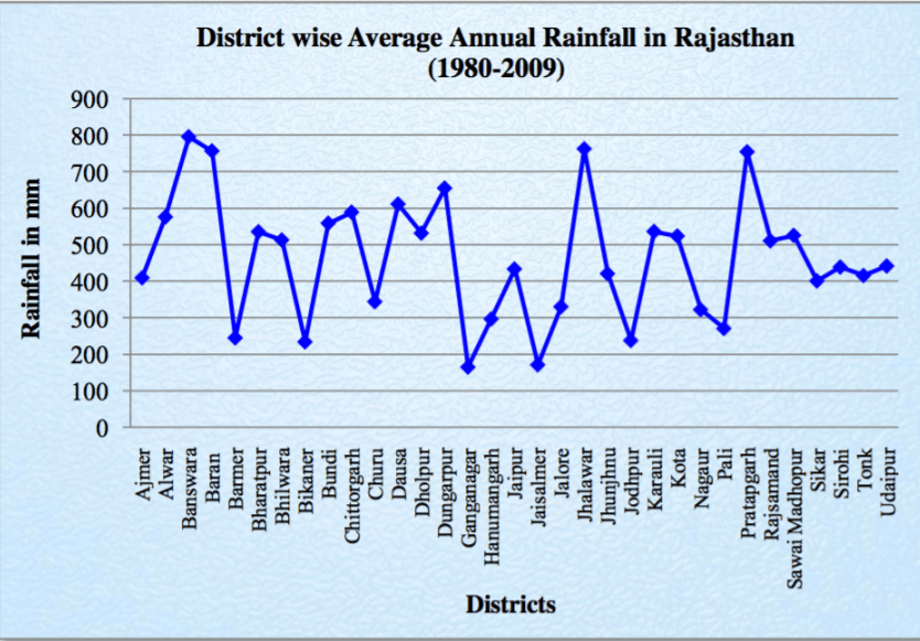
Distribution of Rainfall in Rajasthan:
• There is a wide variation in the mean annual rainfall over Rajasthan as the extreme western parts of Jaisalmer district receive rainfall less than 100mm in contrast to more than 900mm in the eastern parts of Jhalawar and Banswara.
• The districts of East Rajasthan receive more rainfall than those of West Rajasthan. The mean annual rainfall in the East and West Rajasthan is about 64.9 cm and 32.7 cm respectively.
• The maximum rainfall in the state is received in the Southern or South- Eastern districts of the state. On the west of Aravalli hills Pali and Jalore districts receive maximum amount of rain of 50 cm and 43 cm in West Rajasthan.
• In the North or North-Western districts Jaisalmer district receives the lowest rainfall. Bikaner, Ganganagar, Jaisalmer receive annual rainfall of 26cm, 24cm and 17cm respectively. The adjoining areas of these districts constitute the driest zone of the state.
• The lowest recorded annual rainfall in the past 100 years i.e. between 1900 and 2010 was 24 mm in the western Rajasthan and whereas it was never below 120 mm in the eastern Rajasthan.
Temperature Variation in Rajasthan
• The Rajasthan state experiences more or less uniform day temperatures over the plains except during the winter when temperatures increase southwards and during monsoon season when temperatures increase northwards.
• During the southwest monsoon the night minimum temperatures are more or less uniform but generally they are lower in higher latitudes.
• As compared to the plains the day and night temperatures over the plateau and at high level stations are lower. In the hottest month of May the mean maximum temperature is approximately around 41°C- 42°C in the plains, but it is 2°C to 4°C lower in the elevated and plateau regions of the state. The Graph depicts the average mean temperature of Rajasthan district-wise from the year 1980 to 2009.
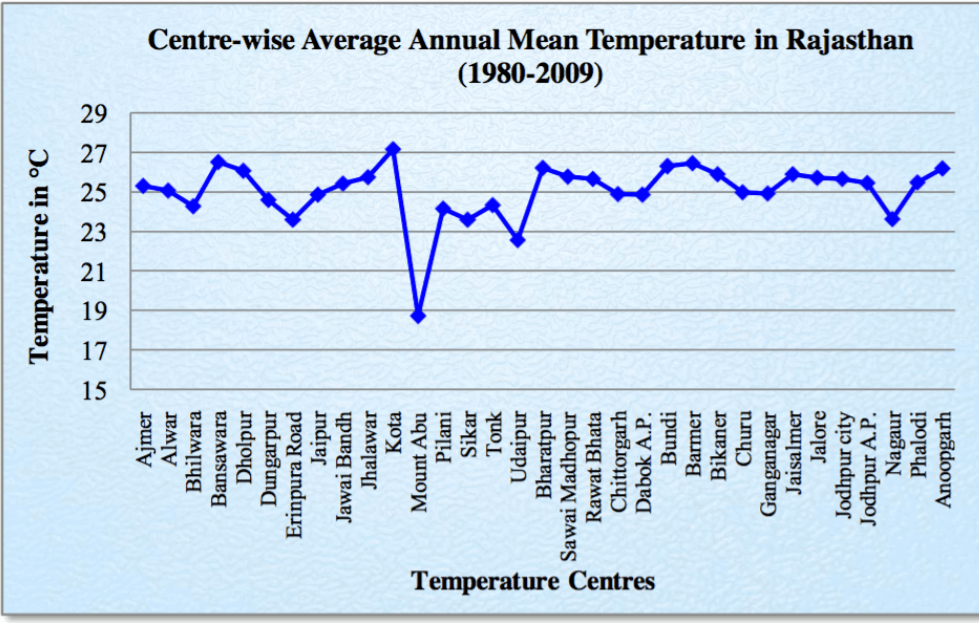
• The mean minimum temperature in the coldest month of January in the state is 7.4°C, which varies from 4°C in the north to 12°C in the south.
• With the arrival of western disturbances much lower winter temperature may be experienced. Minimum temperature 2°C – 5°C below the freezing point can be recorded at few stations of northern Rajasthan.
• In the past 50 years the lowest minimum temperature at a plain station ever recorded was -5.9°C at Jaisalmer on 12 January 1967 (12.8°C below the respective normal for the coldest month), while the hill station of Abu had recorded the lowest temperature of -7.4°C on 12 December 1994 (13.1°C below the respective normal for the coldest month).
• The maximum temperature rise rapidly from February onwards till May and minimum temperature from February onwards till June. The increase in maximum in the period from January to May ranges from 13°C to 20°C at individual stations as we proceed from south to north of the state.
• From the beginning of June to the end of July, the maximum temperature falls by about 3°C to 7°C whereas the minimum temperature falls only by about 3°C to 5°C from June to September. A slight rise in the maximum temperature is experienced in the month of September due to increased insolation.
• Post-September the night temperatures start falling rapidly while day temperatures too start falling rapidly after October and by January both attain their lowest values. There is about 8°C to 15°C fall in minimum temperature and maximum temperature fall by 5°C to 7°C. In both cases, the fall increases from southern parts of the state to the northern parts.
• Smallest diurnal range of temperature is experienced during July and August of about 9°C in the state. After the withdrawal of the monsoon the diurnal range of temperature increases. The diurnal range is greatest in November month.
Solar Radiation and Sunshine Availability in Rajasthan
Solar Radiation
• Rajasthan region receives abundant quantities of solar radiation especially the western parts of the state. The mean duration of bright sunshine in this region is 8.0 to 8.8 hr/day.
• The maximum sunshine period of 9.6 to 9.8 hr/day is in October for western part of Rajasthan whereas it is 10.0 to 10.5 hr/day during April and May for eastern part.
• In rainy month of August the sunshine is available only for about 4.4 to 7.1 hrs/day.
Cloudiness
• In a year, Rajasthan has 300-330 days of clear sunshine.
• Even during rainy season of July and August, the skies remain clear for 8-9 days/month in west Rajasthan and for 4-5 days/month in east Rajasthan.
• The cloud cover decreases to a great extent over the entire state during October.
Fog
• Fog occurs occasionally due to lack of sufficient moisture in the region.
• The maximum frequency of occurrence of fog is during December and January in both Western and Eastern Rajasthan.
• During the monsoon season hill fog occurs at few places, when air is almost saturated and is easily cooled below the dew point while rising over high elevations.
Evapotranspiration
• The annual potential evapotranspiration values vary widely between eastern and western Rajasthan.
• In Dungarpur and Banswara districts the annual potential evapotranspiration is less than 1300 mm whereas it is more than 2000 mm in Jaisalmer district.
Wind Regime and associated phenomenon
• The wind directions are mostly south-westerly during large part of the year whereas during winter they are northeast to north.
• During the winter season the Winds are light and variable but in summers especially around May to July strong winds prevail in the most parts of Rajasthan.
• Summers witness severe dust storm period too when the wind speed rises up to 60 kilometer per hour causing erosion from the dry soils.
Wind Velocity
• There is a direct link between wind velocity and seasons.
• The wind speed reaches the highest in the month of June, which starts rising from the month of April. The wind speed starts gradually decreasing and comes to minimum in the month of November.
• In the Western Rajasthan, Jaisalmer has the highest mean monthly wind velocity followed by Jodhpur.
• On the eastern side Jaipur has the highest mean monthly wind velocity. For the most of the days during a year the Wind speed remains 1-19 km per hour all over the State (Indian Meteorological Department, 2010).
Dust storms
• For the occurrence of both thunderstorms and dust storms convective activity is essential. When the moisture is insufficient in the atmosphere, dry thunderstorms or dust storms occur.
• Dry and hot winds known as ‘Loo’, blow in the afternoon, and very often, they continue to well into midnight. Dust storms in the evening are very common in May for south-eastern areas and in June for north-western part of state. Ganganagar has about 27 days of dust-storm followed by Bikaner and Jodhpur.
• Dust storms are mainly confined to the summer months of March-June.
Thunderstorms:
• Thunderstorms are associated more with eastern part of the state then the arid western areas.
• The maximum occurrences of thunderstorms are during July (with approach of Monsoon) in the state and minimal in the months from November to January.
• The average number of days of thunderstorms during the monsoon season is about 11 in West Rajasthan and 10 in East Rajasthan.
• The average annual number of thunderstorms in the West and East Rajasthan are 17.0 and 15.0.
• Hail is sometimes accompanied with Pre-monsoon and monsoon thunderstorms.
Atmospheric Sea Level Pressure and Winds:
• There is a very systematic manner in which the seasonal variations of atmospheric pressure take place over the state, with a maximum in the winter (January) and a minimum in the monsoon season (July).
• Except during the late summer and monsoon season the pressure gradient generally remains weak over the state.
• During winters the higher pressure is to the north and during summers the pressure decreases from south to north in Rajasthan.
Weather Seasons of Rajasthan
• The geographical diversity of the state causes varied weather conditions even during same season.
However, Rajasthan has four distinct weather seasons:
• The hot weather season (March to Mid June)
• The season of general rains (mid-June to September)
• The season of retreating monsoon (October – November)
• The cold season (December to February)
The Hot Weather Season
• With the apparent northward movement of the sun towards the Tropic of Cancer in March, temperatures start rising in north India. April, May and June are the months of summer in north India.
• Dry and hot winds known as ‘Loo’, blow in the afternoon, and very often, they continue to well into midnight. Dust storms in the evening are very common in May for south-eastern areas and in June for north-western part of state. Ganganagar has about 27 days of dust-storm followed by Bikaner and Jodhpur.
• Duration: Season is initiated in March and prevails from April to Mid-June.
• Average Mean Temperature: The maximum daily temperature in the western parts of Marusthali mainly at Bikaner, Phalodi, Barmer, and Jaisalmer goes upto 40-45 °C.
• Rainfall: Sometimes, the dust storms bring a welcome respite from the oppressing heat since they bring with them light rains and a pleasant cool breeze.
The Season of General Rains
• As a result of rapid increase of temperature in May over the north-western plains, the low pressure conditions over there get further intensified. By early June, they are powerful enough to attract the trade winds of Southern Hemisphere coming from the Indian Ocean.
• These southeast trade winds cross the equator and enter the Bay of Bengal and the Arabian Sea, only to be caught up in the air circulation over India. Passing over the equatorial warm currents, they bring with them moisture in abundance.
• After crossing the equator, they follow a south-westerly direction. That is why they are known as southwest monsoons.

• As these winds approach the land, their south-westerly direction is modified by the relief and thermal low pressure over the northwest India. The monsoon approaches the landmass in two branches:
(i) The Arabian Sea branch
(ii) The Bay of Bengal branch
• While both of these branches aim to reach the low pressure area of northern plains, yet, Rajasthan has considerable less rainfall because of following reasons:
• The Bay of Bengal branch already gives up its moisture during its passage through Ganga plain.
• Further, as Aravali range stretches from south-west to north-east direction, so western part of Rajasthan lies in leeward side of the Bay of Bengal branch and receives little or no rain from this branch.
• same Aravalli Range lies parallel to the direction of Arabian Sea branch and fails to interrupt this branch of monsoon. However, in the southern Aravallis, the mountains have slight east-west span thus Mount Abu in south receives highest rainfall.
Thunderstorms:
• Thunderstorms are associated more with eastern part of the state then the arid western areas.
The Season of Retreating Monsoon
• The months of October and November are known for retreating monsoons. By the end of September, the southwest monsoon becomes weak as the low pressure trough of the Ganga plain starts moving southward in response to the southward march of the sun.
• The monsoon retreats from the western Rajasthan by the first week of September. It withdraws from Rajasthan, Gujarat, Western Ganga plain and the Central Highlands by the end of the month.
• The retreating southwest monsoon season is marked by clear skies and rise in temperature. The land is still moist. Owing to the conditions of high temperature and humidity, the weather becomes rather oppressive. This is commonly known as the ‘October heat’.
• Duration: October – November
• Average Mean Temperature: The temperature is fairly uniform with maximum ranging from 33-36 °C and minimum ranging from 17 – 21 °C. The month of november is slightly cooler.
The Cold Weather Season
• Duration: January – February
• Average Mean Temperature: Ranges from 12 °C in North of State to 16 °C in the south in January.
• Winds: During the cold weather season, the sun migrates to the southern hemisphere and creates high-pressure condition over the northern plain. As a result, winds start blowing from north-western high pressure zone to the low air pressure zone over the Indian Ocean in the south.
• Rainfall: The pleasant weather conditions, however, at intervals, get disturbed by shallow cyclonic depressions originating over the east Mediterranean Sea and travelling eastwards across West Asia, Iran, Afghanistan and Pakistan before they reach the north-western parts of India.
• On their way, the moisture content gets augmented from the Caspian Sea in the north and the Persian Gulf in the south.
• These cyclonic depressions are called ‘Western Disturbances’ and provide rain for rabi crops in the state.
Traditional Indian Seasons
• In the Indian tradition, a year is divided into six two-monthly seasons.
• This cycle of seasons, which the common people in north and central India follow is based on their practical experience and age-old perception of weather phenomena.
• However, this system does not match with the seasons of south India where there is little variation in the seasons.

IRRIGATION IN RAJASTHAN
Rajasthan has Net Cropped area of 183.49 Lac hectares, out of this, approximately 75% of area is rainfed (116.88 lac hectares) and only 25% is irrigated area (66.61 lac hectares). However, this 25% irrigated area contributes more than 50 percent of agricultural output.
Main sources of irrigation in Rajasthan are:
• Open Wells: 31.62%
• Tube-wells: 41.91%
• Canals : 24.45%
• Tanks: 0.84%
• Other sources: 1%
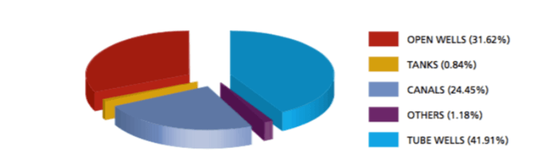
• As can be seen above, 73% of irrigation is through tube-wells and wells placing enormous stress on groundwater.
• It is particularly alarming that share of tube-wells over the last four decades has shot up from 1 percent in 1967-68 to 39 percent.
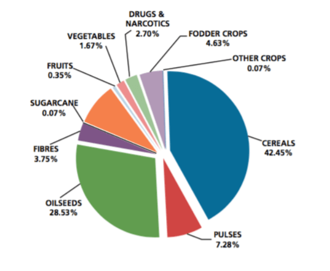
Irrigation in Rajasthan by Crops:
• Of the total irrigated area, 35.79 percent is under wheat, 23.65 percent under rape seed and mustard, and 5.8 percent under grams.
Rajasthan Irrigation Potential
• The state’s estimated irrigation potential is 5.1 million hectares, of which 3.1 million hectares is already achieved.
• This gap of two million hectares cannot be further addressed by groundwater, which is fully exploited.
Acts related to Irrigation:
• The Rajasthan Irrigation and Drainage Act, 1954
Organisations related to Irrigation:
• Irrigation Management & Training Institute, Kota
• Watershed Development and Soil Conservation Department
• Command Area Development & Water Utilization Department
• Indira Gandhi Nahar Department
Major Canal Irrigation Projects of Rajasthan
• Irrigation is an important input by itself for agriculture like fertilisers, improved seeds etc which imparts confidence to the farmers to adopt improved agricultural practices.
• The State government has given high priority to the development of surface water resources during the last four decades of planned development.
• A large number of irrigation projects have been planned and executed in different parts of the State.
Major Canal Irrigation Projects in Rajasthan:
Indira Gandhi Nahar Pariyojana (INGP)
• Indira Gandhi Nahar Pariyojana (IGNP) started in 1958 and the irrigation facility started in 1961. The area of the project spans over four districts of Rajasthan, namely – Ganganagar, Bikaner, Hanumangarh and Jaisalmer.
• Its main aim is to assist in agricultural activities and provide drinking water, but it also envisages regional development and ecological improvement by arresting desertification.
Bhakra Nangal System
• The Bhakra Nangal system is a complex system of several dams, reservoirs, inter-basin transfer linkages, powerhouses and a vast canal network.
• Sutlej waters were distributed between Punjab and Rajasthan as per the Bhakra Nangal Agreement 1959 with Rajasthan’s entitlement at 15.22 percent.
• Forty-nine percent of the project’s canal command area (CCA) is in Haryana, 35 percent in Punjab, and 16 percent Rajasthan. In Rajasthan, this translates to 372,000 hectares or 1.45 percent of state’s cultivable area, served by the 1,219 km long Bhakra-Sirhind canal distribution system.
• Only two districts of Sriganganagar and Hanumangar are covered by the project.
Bikaner / Gang Canal
• The 114 km-long Gang Canal was the rst to come into existence and became fully operational in 1928, with a 1,251 km long distribution system to serve Sri Ganganagar district.
• Along with the Bikaner feeder, it provides water to a command area of 300,000 hectares with 65 percent intensity.
Chambal Valley Project
• The Chambal Valley Project is a major multipurpose project, constructed across the river Chambal by the State of Rajasthan and Madhya Pradesh for irrigation and hydro – power generation.
The Project includes:
• Jawahar Sagar Dam Project
• Rana Pratap Sagar Dam
• Kota Barrage
Chambal command area in Rajasthan is spread over six panchayat samitis (groups of villages) in Kota, Bundi and Baran districts.
Gurgaon Canal Project:
• To utilize 500 cusecs of Yamuna Waters through Agra Canal during the rainy season for irrigation Gurgaon Canal Project is being constructed.
• This will facilitate the irrigation of Kharif crops in 185 villages of Deeg and Kaman tehsils of Bharatpur district.
• The States of Uttar Pradesh, Haryana, Rajasthan and Delhi have signed an agreement regarding the sharing of Yamuna waters.
Sidhmukh Nahar Project
• Sidhmukh Nahar Project is for providing irrigation facilities to Sidhmukh Nohar areas in northern part of the state. The project is undertaken with the assistance of European Economic Community.
Indira Gandhi Canal
• Aim: To rejuvenate to great desert.
• This project previously known as Rajasthan Canal Project.
• It covers an area 600 Km long and 45 Km wide of the Thar Desert in North-west of Rajasthan.
• RCP was first conceived on 29 October, 1948.
• RCP was taken up by the Central Water and Power Commission in 1951.
• It was came to reality in 1951-53
• The physiographic of the area is characterized by vast stretches of undulating windblown sand dunes, which sometime rise above 60 m.
• Parameters:
o Area to be irrigated annually- 29 Lakh acres.
o Length of main canal- 445 Kms.
o Length of branches- 832 Kms.
o Depth of water- 6.25 m.
o Bed width lined canal- 38 m.
o Discharge at head- 18500 cusses
o Length of distributaries and minors- 547 Kms.
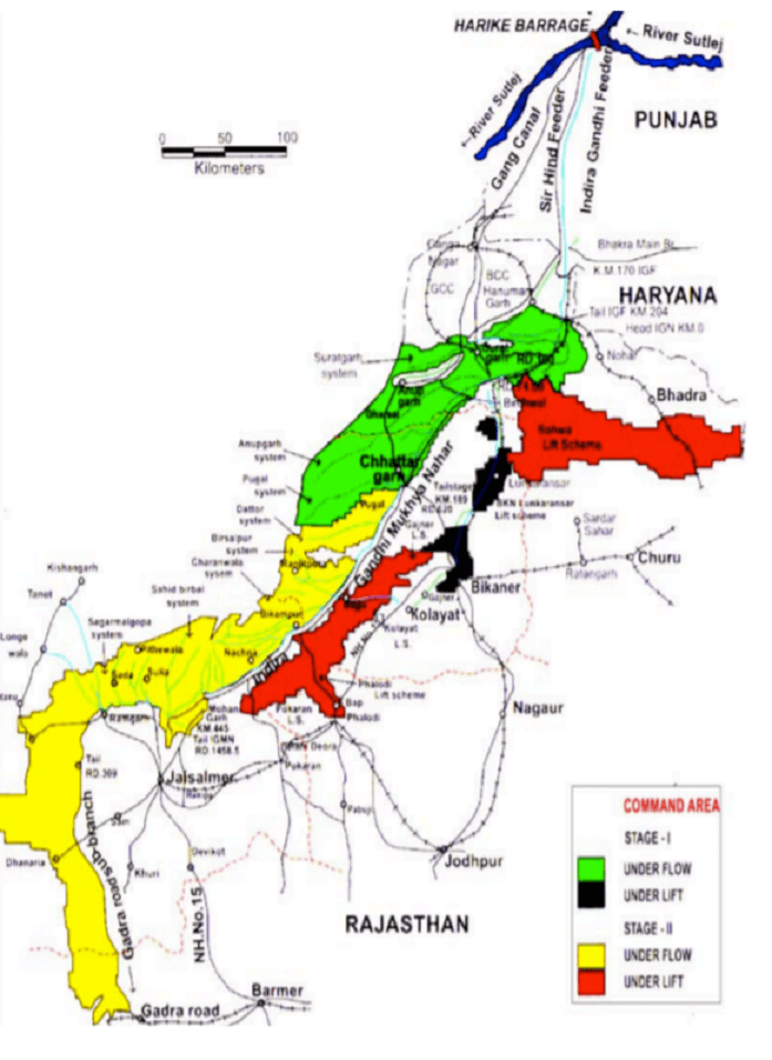
Indira Gandhi Canal Stage I:
• This stage comprising construction of 204 Km long feeder canal, 189 Km long main canal and 3454 Km long distributaries.
• Origin- from the Harike dam situated on the confluence of rivers Sutlej & Beas.
• Feeders: Ferozpur Feeder and Makhu Canal at 3 km downstream of confluence of the rivers Sutlej and Beas
• Provide Irrigation- First stage has been providing irrigation facilities to 5.63 lakh hectares.
• A culturable command area of 5.5 lakh hectare.
• End- Comes to an end near Masitawali in Hanumangarh. This is called Rajasthan feeder.
Indira Gandhi Canal Stage II:
• The IGNP stage-II starts from the tail of stage-I i.e. from Km 189 of IGNP main canal.
• Indira Gandhi Nahar Project, Stage-ll comprises of 256 km long (Km189 to Km445) main canal.
• This stage of estimates to provide flow into 7.0 lakh hectare to culturable command area up to Gardra Road in Barmer district
• It lift irrigation in block to 3.12 lakh hectare. Culturable command area under 5 lifts schemes up to 60 m. Reservation of 1800 cuses of water for drinking water supply and industrial usages.
• Water released up to Tail near Mohangarh in Jaisalmer district on 1st January, 1987 by assuming a total length of 649 Kms.
• With the completion of Lathi Series water has started flowing and it is being used for cultivation.
• Form Mohangarh, a new branch is being taken out which is 90 Kms. in length and has been named as Leehva branch. It has been extended up to Gardra town in Barmer. The region is undulating and therefore Seven lift canals have been constructed to lift up the water up to 60 m.
• The lift canals are
o Bikaner-Lunkaransar
o Gajner lift canal
o Nohar-Saheve lift canal
o Kolayat lift canal
o Phalodi lift canal
o Pokaran lift and
o Bangarsar lift canal
• On completion, irrigation potential of about 19.63 lakh hectares are would be created every year.
• Irrigation facilities were created in 15.73 lakh hectares by the end of March, 2009.
• Agriculture output of about Rs. 1750 crore is produced annually with the help of this project.
• It also provides drinking water.
o Kunwar Sain lift canal is providing drinking water to Bikaner city and 99 villages situated out of the project area.
o Gandhelilsheva lift scheme is providing drinking water to 175 villages of Churu district.
o Jodhpur lift scheme is providing drinking water to Jodhpur city and enroute town and villages.
o After completion of project, 1.80 crore population of eight districts of Western Rajasthan will avail drinking water facility.
Eastern Rajasthan Canal Project (ERCP):
• In Rajasthan Budget 2018, the Chief Minister has announced several schemes to the tune to Rs 52,000 crore, including development of the Eastern Rajasthan Canal Project (ERCP) at cost of Rs 37,500 crore.
• The detailed project report for the ERCP has been sent to the Centre and Central Water Commission (CWC) has already approved its working.
Background of Eastern Rajasthan Canal Project
• The surface water of Rajasthan has been divided into 15 River basins and one outside basin area. It is estimated that out of fifteen river basins surplus water is available only in Chambal and Mahi basin.
• Within Chambal basin, during rainy season Kunnu, Kul, Parbati, Kalisindh, Mez, and Chakan subbasins are also having surplus yield, while Banas, Banganga, Ghambhiri and Parbati sub-basins are deficit in yield.
• Hence, Eastern Rajasthan Canal Projects (ERCP) is planned to harvest surplus yield available in the Southern Rajasthan rivers and transfer to deficit basins in South-Eastern Rajasthan.
Eastern Rajasthan Canal Project: ERCP
• The project will link the Kalisindh, Gambhiri and Parbati rivers
• ERCP is planned to meet the Drinking / Irrigation and Industrial water needs of the 13 districts of Southern & South Eastern Rajasthan viz. Jhalawar, Bara, Kota, Bundi, Sawai Madhopur, Ajmer, Tonk, Jaipur, Dausa, Karauli, Alwar, Bharatpur and Dholpur of Rajasthan for Humans and Live stock till year 2051.
• The project will help to irrigate nearly 10 lakh acres of land, giving a boost to agriculture in the state
Additional Benefits:
o Will enhance availability of surface water & Ground water in the region.
o Will also take care of Flood/ Drought situation in the area.
o Would also boost the Delhi-Mumbai Industrial Corridor (DMIC) in Alwar district and generate employment for youths of the state.
• The state is likely to seek 60 percent financial assistance from the Centre to the project under national project scheme.
• The Project will be executed in three phases.
o The first phase of the project will extend from Galwa Dam to Dholpur,
o The second phase will extend from Galwa to Bisalpur-Isarda,
o The third phase will extend from Galwa to Alwar
Time Schedule:
• The project is proposed to be completed in three phases in seven years from year 2017 to 2023.
• First Phase of about 18474.0 crore is proposed to be completed in five year from year 2017 to 2021