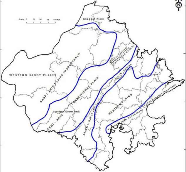
PHYSICAL DIVISIONS OF RAJASTHAN
Rajasthan is the largest state in the Union of India and has more physical variations than any other state. It has regions of rolling sand dunes in the west to lofty rocks in the middle to fertile plains in the east.
On the basis of relief features, there are following physical divisions of Rajasthan:
1. Western Sandy Plains
2. Aravalli Range and Hilly Region
3. Eastern Plains
4. South-eastern Rajasthan Pathar (Hadoti Plateau)
1. Western Sandy Plains
The western sandy plains are divided into two major regions and 6 sub-regions as following
A. Sandy Arid Plain
A1. Marusthali
A2. Dune free Tract
B. Semi-Arid Basin or Rajasthan Bangar
B1. Luni Basin
B2. Shekhawati Region
B3. Nagaur Upland
B4. Ghaggar Plain
2. Aravalli Range and Hilly Region
Aravalli Range on basis of its general characteristics, form elements, relief, slope and drainage pattern can be divided into following physiographic sub-units:
A. The North- Eastern Hill Tracts or Alwar Hills
B. The Central Aravalli Range
B1. The Sambhar Basin or Shekhawati Tow hills
B2. The Merwara hills
C. The Mewar Rocky region and Bhorat Plateau
D. Abu Block region
3. The Eastern Plains
The eastern plains can be divided into 3 sub-regions:
A. Chambal basin
B. Banas Basin
C. Mahi or Chappan Basin
4. South-eastern Rajasthan Pathar (Hadoti Plateau)
It has following sub regions:
A. Deccan highlands
B. Vindhyan region
1. Western Sandy Plains
• Districts: Hanumangarh, Sriganganagar, Bikaner, Jaisalmer, Barmer, Jalore, Sirohi, Pali, Jodhpur, Nagaur, Churu, Sikar & Jhunjhunu.
• The western sandy plains are divided into two major regions and 6 sub-regions as following
A. Sandy Arid Plain
• Area- 61% of total area of W.S.P.
• Population- 40%
• Maximum Rainfall- 30 Cm
• There are vast expanses of sand & rock outcrops where mainly limestone is found, in Jaisalmer, Barmer, Bikaner, Churu, Planumangarh & Sriganganagar.
Sandy Arid Plain further Sub-divided into two sub-regions.
A1. Marusthali
• Districts- Bikaner, Barmer, Jaisalmer, Jodhpur, Nagaur, Churu
• Area – 120500 Sq. Km (Thar Desert)
• Height of sand dunes – 6 m to 60 m
• Length of sand dunes – 3 km to 5 km
• Towards west this sandy arid Marushthali is known as Thar Desert. Shifting sand dunes is locally terms as Dharians.
A2. Dune free Tract
• Districts- Bikaner, Jaisalmer (Phalodi & Pokhran)
• Area – 65 Sq. Km.
• Limestone & Sandstone rocks exposes here belong to Jurassic & Eocene formations.
• It is rocky but dune free tract.
• Small hills are found within a circle of 64 Km of Jaisalmer town
• Dry beds & banks could easily be tapped for ground water
• Grid conglomerate, gneiss, schist & granite rocks are also exposed at places.
B. Semi-Arid Basin or Rajasthan Bangar
• District – Jaipur, Jodhpur, Nagaur, Pali, Jalore, Barmer
• Area – 7500 Sq. Km
• Rainfall – 25 cm
• In it lies in the eastern part & drained by the Luni in its south-eastern portion.
• Gullying has given rise to conglomerate landscape. Its eastern part is covered with superficial sand deposits.
• Towards north lies the Shekhawati tract which is semi arid transitional plain characterized by inland drainage & stream with salt lakes like Sambhar, Didwana etc.
• In the extreme north lies the Ghaggar Plain.
B1. Luni Basin
• District – Barmer, Jalore, Jodhpur, Nagaur
• Area – 34866.4 Sq. Km
• Basin is drained by the Luni River & its tributaries Bandi, Sagi, etc. Covers the area from its source to Tilwara (Barmer) till where Sukri river meets it.
• It is a seasonal river
• Floods occur during the rains in Luni
• Topography is marked by hills with steep slopes & extensive alluvial plains.
• This area is locally known as Naid (Rel) & is one of best alluvial plains.
B2. Shekhawati Region
• District: Churu, Sikar, Jhunjhunu & Nagaur
• Livestock, milk production & dairy are the occupation of this region
• Aravalli hills runs through this region from south to north, cutting into almost two halves.
• Topography of the Shekhawati tracts is characterized by an undulating sandy terrain traversed by longitudinal sand dunes. There is only one seasonal river Kantli.
• The calcareous substratum is exposed of the tract from the sea level is 450m.
B3. Nagaur Upland
• District: Nagaur
• Average height of this region from sea level – 300 m to 500 m
• Rainfall – 25 cm in west to 50 cm in east
• This region is full of sand hills & low depressions.
• The temperature being High, the evaporation of the saline flood-water results in the deposits of the salt & soda in these depressions.
B4. Ghaggar Plain
• Districts- Hanumangarh & Sriganganagar
• No existing river or stream except ancient Ghaggar and region is known as Ghaggar plain.
• It is a sandy plain interspersed with sand-dunes (6-30m high) & small sand-hills.
2. Aravalli Range and Hilly Region
• Rajasthan is bisected by Aravalli range into two major parts: Southeast Rajasthan and Northwest Rajasthan. Aravali range is approximately 692 kms long, running across Gujarat, Rajasthan, Haryana and Delhi.
• The Aravalli’s in Rajasthan are divided into 4 main sections:
1. North-Eastern Aravalli Range
2. Central Aravalli Range
3. The Mewar Rocky region and Bhorat Plateau
4. Abu Region
1. The North- Eastern Hill Tracts or Alwar Hills
• Districts- Jaipur, Sikar, Jhunjhunu, Alwar, Sawai Madhopur.
• Stretches from Delhi to isolated hills of Alwar & Jaipur.
• They are also called as Alwar hills.
• Average Height: 300 m to 670 m
• Valleys between the hills are wide & in some cases stretch for many kilometers.
• Flattered hill tops- form small plateaus.
• Lakes- Sambhar, Ramgarh, Pandupole
• To north & east it merges with Ganga-Yamuna Plains.
• Hill Ranges
o Malkhet & Khetri Group of hills
o Torawati Hills
2. The Central Aravalli Range:
• Districts: parts of Ajmer, Tonk, Jaipur
• Length of central Aravalli range is 100 Km with width of 30 Km and valleys with depth of 550 m.
• Height/ Elevation- 700 m
• Highest Peak/elevation- 799 m in Rajgarh
• The central/Aravalli extends from Sambhar Lake to the Bhorat Plateau
• Surrounded on
o North by – Alwar Hills
o East by Karauli table-land
o South by Banas plains
o West by Sambhar basin
3. The Mewar Rocky region and Bhorat Plateau
• Includes areas of Udaipur, Pali & Dungarpur districts.
• Area- 17007 Sq. Km
• Average height- 1225 m
• The highest portion of Aravalli range lies between the forts of Kumbhalgarh & Gogunda in the form of plateau locally known as ‘Bhorat’
• Altitude of Bhorat- 1225 m
• Bhorat plateau is one of the highest table lands of Aravalli
4. Abu region
• District- Sirohi
• Area 5180 Sq. Km
• Elevation: 1200 m
• It has been separated from the main Aravalli range by the wide valley of the West Banas.
Peaks of Aravalli Ranges:
S. No Peak Name Height (m) District
1 Guru Shikhar 1732 Mount Abu, Sirohi
2 Ser 1592 Sirohi
3 Delwara 1442 Sirohi
4 Jarga 1431 Udaipur
5 Achalgarh 1380 Sirohi
6 Kumbhalgarh 1224 Rajsamand
7 Raghunathgarh 1055 Sikar
8 Hrishikesh 1017 Udaipur
9 Kamalnath 1001 Udaipur
10 Khoh 920 Jaipur
11 Taragarh 870 Ajmer
12 Bhairach 792 Alwar
13 Babai 780 Jhunjhunu
14 Bairath 704 Jaipur
3. Eastern Plains
• Districts- Tonk, Bundi, Amjer, Sawai Madohpur, Bhilwara, Chittorgarh, Kota, Bhatratpur
• Percentage- 23.3% of total area of Rajasthan
• Location- South West of Rajasthan
• Eastern plain is subdivided into three regions:
A. Chambal basin
• District- Kota, Bundi, Baran, Tonk, Sawai Madhopur, Dholpur
• Area- 4500 Sq. Km
• Average width- 10 Km
B. Banas Basin
• District- Udaipur, Chittorgarh, Bhilwara, Tonk, Jaipur, Alwar, Sawai Madhopur
• Average height- 280 – 500 m
• Area- 187400 Sq. Km
• It is an elevated peneplain plain drained by Banas & its tributaries.
• It is divided into two sub-regions mentioned below:
B.1 Mewar Plain:
• It is a dissected plain of Archean granite and gneiss.
• Mewar plain gradually slopes towards the east & north-east, with an average elevation of 280- 500 m.
• The Banas & its tributaries Berach, Menal, Bandi, Mansi, Kothari, Khari flow through this plain.
B.2 Malpura-Karauli Plain:
• It is flat upland, which Heron recognized as a —Tertiary Peniplain.
• It is composed of schist & guess with average elevation of 250-350 m
• Alluvial deposits are thick in larger parts of Kishangarh and Malpura.
C. Mahi or Chappan Basin
• District: Dungarpur
• Area: 7056 Sq. Kms.
• The regions lies to the east of Mewar hills & south of the Banas plain.
• The western part of Mahi Basin is hilly but central & eastern parts are fertile plains with extensive cultivation. These plains are also known as Chhappan plains.
• Average elevation of the region is between 200-400 m.
• This dissected plain along with hill tracts of Banswara are Dungarpur are locally known as Bagar.
4. South-eastern Rajasthan Pathar (Hadoti Plateau)
• The region comprises of the eastern & south-eastern part of the state & is known as Hadoti.
• This region locally called Pathar and Uparmal.
• Districts- Bhilwara, Bundi, Kota, Baran & Jhalawar districts.
• It contains about 9.6% of the area of Rajasthan.
• The Great Boundary Fault of the Aravallis forms its northwest boundary, which extends eastward across the Rajasthan border.
• River Chambal drains the large part of this area.
• This plateau is further sub-divided into two sub-regions.
A. Deccan highlands
• Districts- Bundi, Kota
• The western parts of the Vindhyan plateau lie in the form of three concentric escarpments.
• Formed by the exposed rocks of three main sandstones with slate-stones in between.
• This physiography of south east of Rajasthan is also known as Uparmal (high or stony plateau)
• Region is trained by Chambal and its tributaries Kali Sindh, Parwan and Parvati.
• Soil of the region is mostly black with visible deposits of Deccan Trap lava.
B. Vindhyan region
• Districts- Karauli, Sawai Madhopur, Bundi, Kota
• The region presents an undulating topography strewn with boulders, blocks & depressions.
• The scarps are facing towards the south-southeast between the Banas and the Chambal and extend towards the east over Bundelkhand.
• The scarp lands are formed by massive sandstones.
• Average height of the region is between 350-550 m.
RIVERS & DRAINAGE SYSTEM OF RAJASTHAN
Chambal River & its Tributaries
• Chambal river is one of the cleanest perennial rivers of India.
• It originates at Janapav, south of Mhow town, in the Vindhya Range in Madhya Pradesh.
• Chambal flows north through Madhya Pradesh, then through Rajasthan, then forms the boundary between Rajasthan and Madhya Pradesh before joining the Yamuna in Uttar Pradesh.
Origin Janapav near Mhow (M.P) in the Vindhaya mountain range
Length 965 Kms (370 Kms in Rajasthan)
Discharge Yamuna, in Uttar Pradesh
Right Bank Tributaries Parbati, Kali Sindh, Shipra
Left Bank Tributaries Banas, Mei
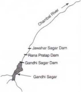
Major Dams Gandhi Sagar, Rana Pratap Sagar, Jawahar Sagar, Kota Barrage
Chambal River in mythology:
• Ancient name of Chambal is said to be Charmanyavati, which may be in reference to the story of king Rantideva sacrificing several cows on its banks.
• Keshoraipattan near Kota is a famous pilgrimage spot dedicated to Lord Vishnu on banks of Chambal.
Chambal River Course:
• Chambal river originates in the Vindyan Range.
• It flows in northerly direction through Madhya Pradesh for about 346 kilometres and enters Rajasthan near Chaurasigarh (Chittorgarh).
• Here the river falls 505 m and then enters a gorge for 113 Kms and leaves it near Kota.
• From Kota, it makes boundary between Kota and Bundi district and then boundary between Rajasthan and M.P passing through Sawai Madhopur, Karauli and Dholpur.
• It eventually enters U.P. and flows for about 32 kilometres before joining the Yamuna near Bhareh.
Chambal River Basin:
• Rajasthan has the largest catchment area of the Chambal river at 79,401 square km, which is 57.86 per cent of the total catchment of the river.
• In Rajasthan, Chambal basin extends over parts of Chittorgarh, Bhilwara, Bundi, Sawai Madhopur, Tonk, Jhalawar, Kota, Baran and Dholpur districts.
Chambal River Dams:
There are four main dams on Chambal river located from south to north
1. Gandhi Sagar Dam
2. Rana Pratap Sagar Dam
3. Jawahar Sagar Dam
4. Kota Barrage
Tributaries of Chambal
1. Kali Sindh
Origin Bagli (District Dewas) in Madhya Pradesh.
Enters Rajasthan at Binda Village.
Length 278 Kms (145 Kms in Rajasthan)
Discharge Chambal, Nonera village in Baran district in Rajasthan.
Tributaries Parwan, Niwaj and Ahu
• Parban River is a tributary of Kali Sindh, that originates in Sehore district of Madhya Pradesh.
• Parban flows through Sehore, Shajapur and Rajgarh districts in Madhya Pradesh .
• It covers Jhalawar, Kota, Baran districts of Rajasthan and meets Kali Sindh in Baran district of Rajasthan.
2. Parbati River:
Origin Vindhyan Range in Sehore district, M.P
Discharge Chambhal, Paliya Village near Sawai Madhopur, Kota Border
3. Mej River:
Origin Near Mandalgarh in Bhilwara, Rajasthan
Discharge Chambal, in Lakheri, Kota
Parwati- Kalisindh-Chambal link
• The proposed Parwati- Kalisindh-Chambal link is one of the big projects being planned in the basin which will divert surplus waters of Parwati and Kalsindh to the Rana Pratap Sagar or Gandhi Sagar dam.
Origin Khamnor Hills, near Kumbhalgarh in Raisamand.
Length 512 Kms
Discharge Chambal near Rameshwar in Sawai Madhopur District
States & Major Cities Nathdwara, Jahazpur and Tonk.
Right Bank Tributaries Berach, Menali
Left Bank Tributaries Kothari, Khari, Dai, Morel and Kalisil
Major Dams Bisalpur
Banas River in Indian mythology
• Lord Parshuram, an avatar (incarnation) of Lord Vishnu, is linked strongly with Banas. Parshuram had killed his mother, Renukaji, on the order of his father. He went to several places seeking salvation. He saw that a calf, who had turned black on killing a man, turned white again after taking a dip in river Banas. Parshuram did the same and was relieved of the sin. The place is now called Matrikundya and falls in Bhilwara district. It is also known as the ‘Haridwar of Rajasthan’.
• Jargaji, an important pilgrimage, is located around 10 km from the origin point. Jarga ji was a devotee of Baba Ram dev, chief deity of the Meghwal community.
• The Triveni Dham near Mandalgarh in Bhilwara district where Berach and Menali rivers meet Banas also holds great value.
• At Sawai Madhopur, Rameshwaram Ghat is a famous pilgrimage spot as Banas merges into Chambal here.
Banas River Basin:
• Banas lies completely within Rajasthan and has the largest catchment area (45,833 square km) in Rajasthan.
• Banas drains the east slope of the central portion of the Aravalli Range, and the basin includes all or part of Pali, Rajsamand, Udaipur, Tonk, Ajmer, Bhilwara, Bundi, Chittorgarh, Dausa, Jaipur and Sawai Madhopur districts.
Tributaries of Banas:
1. Berach or Bedach
• Berach originates at Gogunda hills in the Udaipur District and is known by name of Ahar river.
• It is called Berach after appearing from Udaisagar lake near Udaipur.
• It flows northeast through Udaipur, Chittorgarh and Bhilwara districts, joining the Banas near Bigod village of Bhilwara district.
• Berach has significant historical significance with banks of Ahar having thrown up evidences of settlements dating back to the Harappan and pre-Harappan eras cultural levels, thus exhibiting connection with Indus Valley civilization.
• Additionally, evidences of big palaces were found at Nagri, an ancient site around 16 km from Chittorgarh.
2. Kothari River
• Kothari River rises from the Aravalli hills near Devgarh in the Rajsamand.
• It flows through Bhilwara and ultimately joins the Banas river at Nandrai in Kotri tehsil.
• The Meja dam on the Kothari river provides drinking water to the Bhilwara district.
3. Khari River
• Origin- Hills of Bijral village, North of Rajsamand district
• Length- 80 Km
• It meets near Banas river near Deoli (Tonk).
4. Dai River
• River Dai originates in the south-eastern slopes of the Aravalli Range, near Nasirabad tehsil of Ajmer.
• It flows southeast and then east in Ajmer District and for a short distance through Tonk district, before joining Banas River near Bisalpur village in Tonk district.
5. Morel River
• One branch of river Morel originates in the hills near Dharla and Chainpura villages in Bassi tehsil of Jaipur District and the second branch makes by receiving water from the catchment area of foothills of Paplaj Mataji mountains, district Dausa.
• It flows southeast and then southwest to meet river Dhund, and then again southeast through Jaipur, Dausa and Sawai Madhopur, eventually joining Banas river near Hadoli of Sawai Madhopur District.
6. Kali Sil River
• The River Kalisil originates in the hills near Rajpura village in Sawai Madhopur district.
• The river flows generally southwest, partly through hills and partly in the plains of Sawai Madhopur district, finally joining the Morel River.
Major Dams on Banas River
• Bisalpur Dam is a gravity dam on the Banas River near Deoli in Tonk district, Rajasthan, India.
• The dam was constructed in 1999 for the purpose of irrigation and water supply.
Luni River & its Tributaries
• Luni is a major west-flowing river that originates from western slopes of Naga hills, at an elevation of 772 m in Ajmer district of Rajasthan, where it is known as the Sagarmati.
• After passing Govindgarh, it meets its tributary Sarsuti, which originates from Pushkar Lake, and from then on it is referred to as Luni River.
• The name Luni is derived from the Sanskrit word Lavanavati (“salt river”) and is so called because of its excessive salinity.
• The Luni river is not saline until it reaches Balotra, where high salt content in the soil impacts the river.
Origin Naga hills in Ajmer district of Raiasthan
Length 511 Kms
Discharge Rann of Kachchh
States & Major Cities Balotra
Right Bank Tributaries Jojri
Left Bank Tributaries Lilri, Guhiya, Bandi (Hemawas), Sukri, Jawai, Sagi
Major Dams Dantiwada dam, Sipu dam
Course of the river
• Luni River originates in Naga Hills of Aravalli Range, near Pushkar valley in Ajmer district.
• At Govindgarh it meets its tributary Sarsuti and travels in north-western direction towards Nagaur.
• Luni takes a turn and starts flowing in southwest direction through the Aravalli hills in Pali and reaches plains of Marwar region in Jodhpur.
• It continues in the same direction into Barmer and Jalore, eventually discharging into Rann of Kachchh, Gujarat.
• At Rann of Kutch, Luni forms a delta where the water spreads out and does not contribute any runoff.
• The total length of Luni is about 511 kms.
Luni Basin:
• The Luni basin is bounded by Aravalli range and Gujarat plains on the east, by Rajasthan desert on north, and by the Arabian Sea on the south and the west.
• The total area of Luni basin is 32,879 Sq.km and includes several parts of the Ajmer region from Nagaur to Pali and then moving towards Jodhpur and Barmer before its entry into the Jalore district.
Luni Tributaries:
• The main tributaries of Luni joining from left are the Lilri, Guhiya, Sukri, Jawai, Bandi (Hemawas) and the Sagi.
• Jojri is the only major tributary that joins the Luni river from right.
1. Jawai River
• Jawai originates from the Aravalli Ranges in the Udaipur district of Rajasthan.
• Main tributaries of Jawai are Sukri and Khari river.
• Western Rajasthan’s largest dam, the Jawai Dam, is located near Sumerpur in Pali district, on Jawai river.
• Twin cities of Sumerpur and Sheoganj are situated on the banks of this river.
2. Bandi River
• The Rivers Khari and Mithai meet at pickup weir of Bombadra. This confluence gives rise to the Bandi River.
• After flowing for about 45 km, it joins the Luni near the Lakhar village.
• The Hemawas dam is located near Hemawas on this river.
• The district headquarters Pali is located on the bank of Bandi.
3. Sukri River:
• Sukri river originates from the western slopes of Aravalli Range in Pali District and flows through Jalore and Barmer before merging in Luni river.
• Bankli Dam is located on this river in Jalore district.
4. Guhiya River
• Guhiya River is a small river in Pali, which runs only during the monsoon season.
• It rises in the foothills of the Aravalli Range near the villages of Khariya Neev and joins the Bandi River near the village of Phekaria.
Dams on Luni River:
• In 1892, Maharaja Jaswant Singh of Jodhpur constructed Jaswant Sagar in Pichiyak village, Jodhpur district to use the waters of Luni river.
Sabarmati River & its Tributaries
• Sabarmati River is one of the major west flowing river of India, along with Narmada and Tapti.
• It originates from Aravali hill ranges in Rajasthan and after traveling 371 km, meets the Gulf of Cambay (Khambhat) in the Arabian Sea.
• 48 km of the river length is in Rajasthan, while the rest 323 km is in Gujarat.
• Sabarmati originates at an elevation of 762 m near village Tepur, in Udaipur district.
• It flows generally in South – West direction in Rajasthan and enters Gujarat and passes through the plains and continues to flow in the same direction.
Origin Village Tepur, in Udaipur, Rajasthan
Length 371 Kms
Discharge Gulf of Cambay (Khambhat)
States & Major Cities Ahmedabad
Right Bank Tributaries Sei, Siri and Dhamni
Left Bank Tributaries Wakal, Harnav, Hathmati, Khari, Watrak
Major Dams Dharoi Dam
Sabarmati Basin:
• The Sabarmati basin extends over states of Rajasthan and Gujarat having an area of 21,674 Sq km.
• The basin is bounded by Aravalli hills on the north and north-east, by Rann of Kutch on the west and by Gulf of Khambhat on the south.
• The basin is roughly triangular in shape with the Sabarmati River as the base and the source of the Vatrak River as the apex point.
River Course:
• At the 51 km of its run, the river is joined by the Wakal on the left bank near village Ghanpankari.
• After flowing generally in the South – West direction at 67th km of its run, it receives the Sei on the right bank near Mhauri and then the Harnav on the left bank at about 103 km.
• From respective sources beyond this confluence, Sabarmati flows through the Dharoi gorge.
• Emerging from the gorge it passes through the plains and is joined on its left bank at about 170 km from its source by the Hathmati, which is its major tributary.
• Continuing to flow in South – West direction, the river passes through Ahmedabad and about 65 km down stream, another major tributary, Watrak joins it on the left bank.
• Flowing for a further distance of 68 km, the river outfalls in the Gulf of Khambhat in Arabian Sea.
Sabarmati Tributaries:
1. Sei
• This is a right bank tributary of Sabarmati.
• lt rises in the Aravalli hills in Rajasthan and flows in South – West direction for a total distance of 95 km before it joins Sabarmati on its right bank.
• It drains an area of 946 sq km.
2. Wakal
• This is a left bank tributary of Sabarmati.
• lt rises in the Aravalli hills in Rajasthan and flows in South – West direction for a total length of 88 km. It drains an area of 1625 sq km.
3. Harnav
• This is a left bank tributary of Sabarmati River.
• It rises in the northern portion of the Kulalia hills of Rajasthan ranges and flows in South – West direction for a total distance of 75 km. It drains an area of 972 sq km.
4. Hathmati
• This is a left bank tributary of Sabarmati.
• It rises in Gujarat and flows in south-west direction for a distance of 122 km to meet the Sabarmati on its left bank.
• This tributary drains an area of 1526 sq km.
• The sub-tributary of Hathmati river is Guhai river, on which Guhai dam is constructed.
5. Watrak
• This is a left bank tributary of Sabarmati River.
• It rises in Panchara hills in Dungarpur district of Rajasthan and flows in Southwest direction for a distance of 248 km and joins Sabarmati on the left bank.
• Watrak and its tributaries drain an area of 8638 sq km.
Major Dams on Sabarmati River
• There are several dams and reservoirs constructed on Sabarmati and its tributaries.
• The Dharoi dam is located on the main Sabarmati river, while Hathmati dam, Harnav dam, Guhai dam and Watrak dam are located on tributaries.
• The Kalpasar is planned project in the Gulf of Khambhat.
Dharoi Dam:
• Dharoi dam is located about 165 km upstream Ahmedabad in village Dharoi of Mehsana district.
• It was constructed in 1978.
• It has catchment area of 5540 km, out of which about 2640 km lies in Gujarat.
Sabarmati River Concerns:
• The industrial city of Ahmedabad poses the danger of water pollution by industrial waste.
Mahi River & its Tributaries
• Mahi is one of the major inter-state west flowing rivers, along with Tapti River and the Narmada River, of India.
• The total length of Mahi is 583 km.
• It originates in the Mahi Kanta hills, from the northern slopes of Vindhyas at an altitude of 500 m near village Bhopawar, in Dhar district of Madhya Pradesh.
Course of the river:
• Initially the river flows northwards through Dhar and Jhabua districts of M.P. and then turns left and passes through the Ratlam district of M.P., then turning to North – West, it enters the Banswara district of Rajasthan and flows in South – West directions and thereafter enters the Panchmahal district of Gujarat state.
• Then the river continuously flows in the same direction through Kheda district of Gujarat and finally falls into the Gulf of Khambhat in Arabian Sea.
Mahi River Basin:
• The Mahi basin extends over states of Madhya Pradesh, Rajasthan and Gujarat having total area of 34,842 Sq.km.
• It is bounded by Aravalli hills on the north and the north-west, by Malwa Plateau on the east, on the south by the Vindhyas and by the Gulf of Khambhat on the west.
Tributaries of Mahi:
1. Som
• This is a right bank tributary of Mahi. Som river rises on the eastern slopes of the Aravalli hills in the Udaipur district at an elevation of 600 m and flows in the eastern direction to join the river Mahi on the right bank in Dungarpur district.
• Its total length is about 155 km.
• Gomti & Jakham are the major right bank sub tributaries of Som.
2. Anas
• This is a left bank tributary of Mahi.
• Anas River rises in the Vindhyas in Jhabua district in MP and flows in the North – West direction to join Mahi in the Dungarpur district.
• It has a total length of about 156 km.
Hydro-electric projects on Mahi River
There are two major hydro-electric projects constructed on Mahi River.
• Kadana Hydroelectric Proiect Sonagadh, Gujarat
• Mahi Hydroelectric Proiect Banswara
Dams on Mahi River:
Mahi Bajaj Sagar Dam
• Named after Shri Jamnala Bajaj, Mahi Bajaj Sagar Dam is situated 16 kilometres from Banswara town in Banswara district.
• It is the second largest dam in Rajasthan.
• The dam was constructed between 1972 and 1983 for the purposes of hydroelectric power generation and water supply.
• There are large number of islands within the catchment area of the dam, so Banswara also called popularly called as “City of Hundred Islands“.
Kadana Dam
• Kadana Dam is an earthen and masonry dam on the Mahi River in Mahisagar district of Gujarat.
• The dam was constructed between 1979 and 1989.
Mahi River Concerns:
• The silt brought down by the Mahi has contributed to the shallowing of the Gulf of Khambhat and the abandonment of its once-prosperous ports.
• The riverbed lies considerably lower than the land level and is of little use for irrigation.
Rivers of Inland Drainage in Rajasthan
• Nearly 60 percent of the area of the state of Rajasthan has inland drainage system.
• Nearly all of this area lies wet of Aravalli divide and includes a large number of separate basins like Sota-Sahibi basin, Kantli basin and streams in Luni basin.
1. Ghaggar-Hakra River
• Ghaggar-Hakra River is a seasonal in India and Pakistan that flows only during the monsoon season.
• The river originates from Kalka hills (Himachal Pradesh) and is known as Ghaggar before the Ottu barrage and as the Hakra downstream of the barrage.
Origin Kalka Hills of Shivalik Range in Himachal Pradesh
Length 465 Kms
Discharge Sand dunes in Bhawalpur district of Pakistan
Major Cities Punjab: Patiala Haryana: Ambala, Hissar
Rajasthan: Tibbi, Hanumangarh, Talwara, Anupgarh and Suratgarh
Tributaries Chautang, Kaushalya, Sarsuti
River Course:
• Ghaggar rises from Kalka hills of Shivalik Range in Himachal Pradesh and flows through, Patiala (Punjab) and Ambala and Hisar (Haryana) districts.
• It enters Rajasthan and flows through Hanumangarh, Talwara, Anupgarh and Suratgarh.
• Ghaggar flows across the international border through Sri Ganganagar district and assumes the name, Hakra, near Fort Abbas City in Pakistan.
• The river finally enters into Bhawalpur district of Pakistan where it gets lost in sand dunes.
Ghaggar in History-Culture
• Few scholars identify Ghaggar with the vedic river of saraswati.
2. Kantli River:
• Kantli river originates from hills of Khandela hills of Sikar district and taking a northernly course runs into Jhunjhunu and ends in sand dunes near Churu district.
• Site of ancient OCP culture – Ganeshwar lies on bank of Kantli river.
• Catchment area of Kantli river is known as Torawati.
3. Ruparel River
• Ruparel river originates from Udainath hills in Thangazi tehsil of Alwar district.
• It traverses these hills northwards, turning towards the east and northeast before disappearing in Bharatpur District.
• It has a total length of about 104 km.
• The river has been in news, because of its disappearance and revival by efforts of Shri Rajendra Singh
4. Rupangarh River
• Rupangarh river originates from Salemabad (Ajmer) and flows in northerly direction to drain into Sambhar lake.
5. Sabi or Sahibi River
• There are two branches, the Sabi branch rises from Sewar hills and the Sota branch rises from hills of Bairath.
• The river flows in northern direction through Kotputli tehsil, Behror Kishangarh, Mundawar (Haryana) Rewari and empties into Najafgarh drain.
• Sabi basin is bounded in the northwest by Shekhawati River Basin and Ruparail and Banganga River basins in the southeast.
• The northern boundary is shared administratively with Haryana State. The Basin extends over parts of Alwar, Jaipur and Sikar districts.
• The total catchment area of the sabi basin is 4607.9 km2.
• It flows in Rajasthan for a distance of about 157 km before entering Haryana State.
Sabi River in History & Culture:
• Several modern scholars identify the Sahibi River with the Drishadvati river of Vedic period. It is believed that the Drishadwati River had formed one border of the Vedic state of Brahmavarta while other was Saraswati river or the modern Ghaggar-Hakra river.
• Several sites related to Indus Valley civilisation have been found along the route of Sahibi. Among the finds are handmade and wheel-made pottery dating back to over 3,000 years found on the banks of the Sahibi River at Jodhpura near Viratnagar in Jaipur district.
• Other findings include pottery found on the Sahibi riverbed at Hansaka in the Rewari district, Haryana.
• A red stone statute of Vamana Dev was unearthed in 2002 on the Sahibi riverbed near Bawal, Haryana.
POWER & ENERGY – RAJASTHAN
Background
• Development of power resources is pre-requisite for development of any region. Power resources of Rajasthan play a key factor in the modern agricultural, industrial and economic development. While, chronically Rajasthan has been power hungry state, the discovery of petroleum and natural gases resources in west Rajasthan and solar power potential has given new hope in converting Rajasthan into a power surplus state.
• At the time of India’s independence, the total number of towns and villages (in Rajasthan) electrified did not exceed 42 and the installed generating capacity was only 13.27 MW. However, with the formation of Rajasthan State Electricity Board (RSEB) on 1st July 1957, power sector in Rajasthan received priority and power projects began to mushroom all over State.
• Earlier, Rajasthan State Electricity Board (RSEB) was the prime agency for generation, transmission and distribution of electricity in the state. But after 19 July 2000, RSEB has been restructured into 5 different companies to strengthen infrastructure and separate the generation, transmission and distribution functions.
• Generation:
- Rajasthan Rajya Vidyut Utpadan Nigam Ltd.(RVUNL)
• Transmission:
- Rajasthan Rajya Vidyut Prasaran Nigam Ltd.(RVPN)
• RVPN is engaged in transmitting bulk power from generating stations to inter-phase point of Discoms.
• Distribution: 3 Companies region based:
- Jaipur Vidyut Vitran Nigam Ltd.(JWNL)
- Ajmer Vidyut Vitran Nigam Ltd.(AWNL)
- Jodhpur Vidyut Vitran Nigam Ltd.(JdWNL)
Sources of Generation of Power:
• As on December, 2019, the installed power capacity of Rajasthan is 21,175.90 MW (Approximately 21 GW).
• Total increase during the year 2018-19 is 736.96 MW.
Sources of Power Installed Capacity (in MW) Percentage of Total
Thermal Power 12122.46 57.25%
Hydel Power 1757.95 8.3%
Gas Based 824.6 3.9%
Nuclear 456.74 2.16%
Solar 2178.10 10.3%
Wind 3734.10 17.6%
Biomass 101.95 0.5%
Total 21175.90 100%
(Economic Review of Rajasthan 2019-20)
Classification of Sources of Power Generation
The following charts shows classification of power resources.
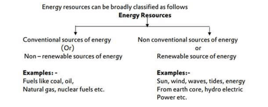
Conventional Power Sources:
Thermal Power Resources of Rajasthan:
• Thermal power plants use coal as fuel for generation. Rajasthan has very poor quality and quantity of coal. Only lignite coal of tertiary era having high sulphur content with low carbon percent (30-35%) is mainly found in Rajasthan.
• Lignite cannot be economically used generating power and hence most of the power plants in Rajasthan import coal from outside.
Thermal Power plants of Rajasthan:
• Suratgarh Super Thermal Power Plant – 1500 MW (6X250 MW) (Sri Ganganagar)
• Kota Super Thermal Power Plant – 1240 MW (2X110, 3X210, 2x 195) (Kota)
• Chhabra Thermal Power Plant – 2320 MW (4X250 MW) + 1320 (2X660 MW) (Baran)
• Kalisindh Thermal Power Station – 600 MW (1×600 MW) (Jhalawar)
• Giral Lignite Power Plant – 250 MW (2X125 MW) (Barmer)
• Barsingsar Thermal Power Station (Bikaner)
• JSW Barmer Power Station (Bhadresh, Barmer)
• Kawai Thermal Power Station (Baran)
• VS Lignite Power Plant (Bikaner)
Important Facts:
Chhabra Thermal:
• Super critical technology based; Unit 5&6 came online in June 2019 – Overall Capacity 2320 MW
• Chahabra Thermal is 1st Power Plant in Rajasthan based on this Super Critical technique
• Future Plan: Three projects of 2,800 MW are under progress:
- Chhabra Thermal Power Project – 2 X 660MW – June 2019
- Suratgarh Thermal Power Project – 2 X 660 MW
- Ramgarh Gas Thermal Project
Oil & Natural Gas Power Resources of Rajasthan
Recently, oil and natural gas resources have been discovered in the western part of the state
Gas power plants of Rajasthan
• Dholpur Combined Cycle Power Station – 330 MW (2 X 110 MW Gas Turbine, 1 X 110 MW Steam Turbine). – RVUNL
• Ramgarh Gas Thermal Power Station – 430 MW RVUNL
Hydro Power Resources of Rajasthan
Hydro-electric power plants of Rajasthan
• Rana Pratap Sagar Dam – 172 MW (4X43 MW)
• Jawahar Sagar Dam – 99 MW (3X33 MW)
• Mahi Bajaj Sagar Dam – 140 MW (2X25 MW, 2X45 MW) – RVUNL
Unconventional Power Resources:
A. Nuclear Power Sources of Rajasthan
• Rajasthan Atomic Power Station, Rawatbhata (1180 MW)
B. Renewable Energy Sources of Rajasthan
Rajasthan has following types of Renewable Energy Sources:
B1. Solar Energy Resources of Rajasthan
Rajasthan shines bright on the solar map of India with 300-330 clear sunny days comparable to deserts of California, Nevada, Colorado and Arizona. Within the state the districts such as Banner, Bikaner, Jaisalmer, Jodhpur are the key regions with best solar radiation. Rajasthan is endowed with two critical resources that are essential to solar power production: high level of solar radiation (6-7 kWh/ m2/ day) and large tracts of relatively flat, undeveloped land.
As per the assessment of Ministry of New and Renewable Energy (MNRE), Rajasthan has a potential of 142 GW of electricity from solar energy. Solar Power plants of 4,637 MW have been commissioned in the State upto December, 2019.
List of Solar Parks in Rajasthan
• Bhadla Solar Park – Total Capacity (Phase I/II/III/IV) – 2255 MWp (Proposed).
• Phalodi-Pokaran Solar Park
• Fatehgarh Solar Park
• Nokh Solar Park
Solar Projects installed in Rajasthan
• List of Solar Projects installed in Rajasthan (1812 MWp)
Rajasthan Solar Energy Development Policy, 2019
• Adoption of electric vehicles has been made part of policy priority. Rajasthan Government will provide land at 50% concessional rate of DLC for first 500 renewable energy-based EV charging stations. These projects will get 100% exemption in normal transmission and wheeling charges for a period of 10 years and 100% electricity duty waiver for 7 years.
• The solar policy aims to develop 33 district headquarters as ‘Green Energy Cities’ in next five year by installing 300 MW of solar rooftop systems.
• RREC will fund solarisation of the Stand Alone Mini Drinking Water Supply Schemes in rural areas by energizing the pumps from solar energy. The project will be taken up on pilot basis for 200 schemes considering the availability of ground water in the area. The project while ensuring the supply of drinking water will also address the issue of non-availability of funds with the Gram Panchayats for payment of electricity bills.
• RREC to undertake studies in Renewable Energy for further policy interventions.
• Policy incentives related to manufacturing of solar energy equipment in Rajasthan.
• Benefits of Micro, Small and Medium Enterprises (MSME) Policy to eligible manufacturers.
• Land allotment at 50% concessional rate in industrial area/any other area.
• Exemption of 100% Stamp duty.
• Full exemption in Electricity Duty for 10 years.
• Investment subsidy on SGST to solar energy equipment manufacturers- 90% of SGST due and deposited for 7 years.
• Employment Subsidy as per RIPS -Reimbursement of 90% paid for employees for 7 years.
• Interest subsidy as per RIPS, treating solar energy equipment manufacturing as thrust sector.
• Setting up of Rajasthan Renewable Energy Development Fund (RREDF) for up-gradation of transmission and distribution infrastructure of the power utilities.
B.2 Wind Energy Resources of Rajasthan
• Rajasthan is one of India’s leading state in tapping wind energy for power generation. The wind energy potential in the State is estimated to be about 18,770 MW at 100 M hub height as per assessment of National Institute of Wind Energy (NIWE) and MNRE, Gol.
• A total of 4,310.50 MW wind power capacity has been established upto December, 2019 in the State.
B3. Biomass Energy
• The main source for biomass energy in the State of Rajasthan is Mustard Husk and Julie Flora. State Government has even issued ‘Policy for Promoting Generation of Electricity from Biomass 2010’ for encouraging investments in the sector.
• Total 13 Biomass Power Generation Plants of 120.45 MW capacity have been established till March, 2019 in the State.
Government Organisation Responsible
Rajasthan Renewable Energy Corporation Limited (RRECL)
• RRECL is the State Nodal Agency of Ministry of New and Renewable Energy for generation of energy from non-conventional energy sources in the State and is also a State Designated Agency of Bureau of Energy Efficiency (BEE) for promoting energy efficiency and energy conservation.